Raymore Drive
Jump to navigation
Jump to search
- See also: Hurricane Hazel
English: Raymore Drive is a mostly residential street near Weston, Toronto, Ontario. Although a canal that would have run through the area was once proposed, by the mid-1950s, it was home to a mix of blue-collar workers and retirees. On October 15, 1954, the area was severely affected by Hurricane Hazel. The Humber River, next to which the street runs, burst its banks in a heavy flood, which killed 35 residents; in contrast, 81 Canadians in total were killed during the storm. The flood was made worse after a footbridge spanning the Humber was torn off one abutment by the rising waters, and redirected the Humber through the neighbourhood. The flood washed away 39% of the street, which was not rebuilt. Residential development in that area was prohibited in the aftermath of Hazel, and the affected area made into Raymore Park.
-
 Almost two fifths of Raymore Drive was destroyed in a flood caused by Hazel; now, the street curves and ends as a parking lot for visitors to Raymore Park which is located where the street previously went.
 -
 A weir was built on the Humber River near Raymore Drive to lessen the risk of a similar catastrophic flood.
 -
 Raymore Park; residential development in this area was prohibited following Hurricane Hazel due to the risk of flooding
 -
 er River was swept off an abutment by the rising waters, and redirected the waters onto Raymore Drive; this new bridge was built in 1995.
 -
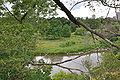
 The Humber River, pictured from the south end of the park. The low-lying west bank suffered catastrophic flooding, while the east one did not.
 -
 A retaining wall was built to support the eastern bank.


