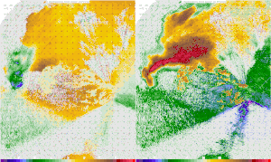
A Doppler on Wheels image of a tornadic thunderstorm near La Grange, Wyoming (USA) captured during the VORTEX2 project. In the velocity image on the left, Blues/green represent winds moving towards the radar, and reds/yellows indicate winds moving away from the radar. The reason that some of the darker blues contain red/yellow within them is a trait known as Aliasing, where the winds are moving faster than the radar can detect. In the reflectivity image on the right, the main body of the storm can be seen, with the appendage on the bottom of the storm being a hook echo, which is associated directly with the tornado, and the tornado circulation itself can be seen as the doughnut like shape in the later part of the animation.
This is the English translation of the Picture of the day description page from 5 June 2023.
A Doppler on Wheels image of a tornadic thunderstorm near La Grange, Wyoming (USA) captured during the VORTEX2 project. In the velocity image on the left, Blues/green represent winds moving towards the radar, and reds/yellows indicate winds moving away from the radar. The reason that some of the darker blues contain red/yellow within them is a trait known as Aliasing, where the winds are moving faster than the radar can detect. In the reflectivity image on the right, the main body of the storm can be seen, with the appendage on the bottom of the storm being a hook echo, which is associated directly with the tornado, and the tornado circulation itself can be seen as the doughnut like shape in the later part of the animation.