User:Twotwofourtysix
| This user contributes using Inkscape. |
My maps: The good, the bad, and the downright weird[edit]
I also make articles on Medium, currently explaining the Indonesian general election maps I've made in greater detail with some context.
(Sorted chronologically by upload date)
Demographic maps[edit]
-

-
 Provincial monthly minimum wage in Indonesia in 2024
 -
 Municipal monthly minimum wage in Indonesia in 2024
 -
 Ratio between the municipal and provincial minimum wages

.svg)
.svg)
.svg)
Transit maps[edit]
(Woah, this is new. Geographically accurate and includes a basemap because I can't otherwise)
.svg)
.svg)
Political maps[edit]
Interactive maps (uses Commons' Data: namespace)[edit]
(Honourable mentions to editors of Philippines and Australian politics, whom I have apparently inspired *teared up eyes* (see en:Negros Occidental's 1st congressional district and en:Division of Longman))
Detailed (proper?)[edit]
| Statewide maps of congressional districts in the US since 2023 |
|---|
Now, more like the style below this section[edit] |


.svg)


| Comparison between older and newer state electoral districts in Australia |
|---|


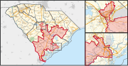
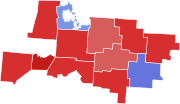
Maps of individual congressional districts (highlighted in red) in each US states since 2023[edit]
I've made these on close to 40 states in the US. See all of them at Category:Congressional district maps of the 118th Congress. Here's just a sample.
-
 Statewide map
 -
 Statewide map, with urban inset(s)
 -
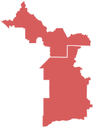
 Zoom-in on an urban area, with statewide inset
 -
 Close-up map of the district itself (Only available for AL, CA, IL, LA, NC, NY, and NJ)
.svg)
.svg)
.svg)
_(since_2023).svg)
Due to mid-decade redistricting in some states, I've also made maps with the last design for updated districts since 2025 until perhaps courts struck them down again or whatever else happens, who knows. They're available at Category:Congressional district maps of the 119th Congress.
Maps of individual state legislative districts[edit]
I've currently made Virginia's thus far in the detailed format, see Category:Virginia State Senate district maps and Category:Virginia House of Delegates district maps.
Others[edit]
-
 Indonesia's national electoral districts (Clickable version at the Indonesian article)

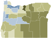
Simple[edit]
| Maps of individual state electoral districts in each Australian states | ||
|---|---|---|
|
_2022.svg)
_2022.svg)
_2022.svg)
_2022.svg)
_2022.svg)
_2022.svg)
_2022.svg)
_2022.svg)
_2022.svg)
_2022.svg)
_2022.svg)
_2022.svg)
_2022.svg)
_2022.svg)
_2022.svg)
_2022.svg)
_2022.svg)
_2022.svg)
_2022.svg)
_2022.svg)
_2022.svg)
_2022.svg)
_2022.svg)
_2022.svg)
_2022.svg)
_2022.svg)
_2022.svg)
_2022.svg)
_2022.svg)
_2022.svg)
_2022.svg)
_2022.svg)
_2022.svg)
_2022.svg)
_2022.svg)
_2022.svg)
_2022.svg)
_2022.svg)
_2022.svg)
_2022.svg)
_2022.svg)
_2022.svg)
_2022.svg)
_2022.svg)
_2022.svg)
_2022.svg)
_2022.svg)
_2022.svg)
_2022.svg)
_2022.svg)
_2022.svg)
_2022.svg)
_2022.svg)
_2022.svg)
_2022.svg)
_2022.svg)
_2022.svg)
_2022.svg)
_2022.svg)
_2022.svg)
_2022.svg)
_2022.svg)
_2022.svg)
_2022.svg)
_2022.svg)
_2022.svg)
_2022.svg)
_2022.svg)
_2022.svg)
_2022.svg)
_2022.svg)
_2022.svg)
_2022.svg)
_2022.svg)
_2022.svg)
_2022.svg)
_2022.svg)
_2022.svg)
_2022.svg)
_2022.svg)
_2022.svg)
_2022.svg)
_2022.svg)
_2022.svg)
_2022.svg)
_2022.svg)
_2022.svg)
_2022.svg)


| Current and future districts of major city councils in the US |
|---|
|
|
.svg)
.svg)
.svg)
.svg)
.svg)
.svg)
.svg)
.svg)


Election (and referendum) maps[edit]
Series of series[edit]
Detailed (proper?)[edit]
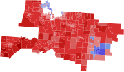
| 2021 Virginia gubernatorial election results maps by precinct in each regions |
|---|
|
|


| 2020 Brisbane local election results maps by ward |
|---|
|


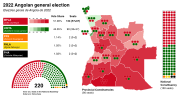
| 2022 Alaska elections results maps by State House district "Nonstandard, unnecessary, goes against the convention" —Milfil "Aesthetically pleasing and informative" —Talleyrand6 |
|---|
|


-
 2019 Bandung City Council election results by electoral district (exclusively in Indonesian)
 -
-
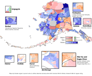 2022 Alaska's at-large congressional district special election results by precinct
 -
 2022 Los Angeles City Council District 1 election results by precinct
 -
 2023 French Polynesian legislative election second round results by constituency
 -
 2023 French Polynesian legislative election second round results by commune
 -
 1955 Indonesian legislative election results by electoral district
 -
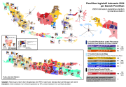
 2019 Indonesian legislative election results by electoral district
 -
 2014 Indonesian presidential election results by municipality
 -
 2014 Indonesian legislative election results by electoral district
 -
 Swing between the 2014 and 2019 Indonesian presidential elections by municipality
 -
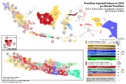
 2024 Indonesian legislative election results by electoral district
 -
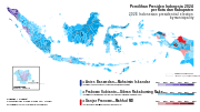 2024 Indonesian presidential election results by municipality
 -
 2024 Indonesian presidential election results by municipality (alternate colour scheme)


.svg)
Simple[edit]
Simple with labels/legend[edit]


Simple with insets[edit]


Simple with >hundreds of polygons[edit]
-

-

-

-
-

-

-

-

-
 2023 Denver mayoral general election (Clickable interactive version)
 -
 2023 Denver mayoral runoff election (Clickable interactive version)
 -
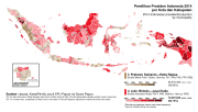
 2019 Indonesian legislative election results by municipality per party (warning: huge)


Just simple[edit]
(Some of these, especially the early ones, have shapes that are stolen taken from other maps)
-

-

-

-

-

-
 Not originally made by me but made its final results update
 -

-

-

-

-

-

-

-

-

-

-

-

-

-

-

-

-

-

-

-

-
-

-

-

-

-

-

-
-

-

-

-
-
 2023 Louisiana gubernatorial election turnout
 -
 2017 United States Senate special election in Alabama turnout


_with_Gradation.svg)


