User talk:Danlaycock/Archive 1
 | This is an archive of past discussions. Do not edit the contents of this page. If you wish to start a new discussion or revive an old one, please do so on the current talk page. |
| Archive 1 | Archive 2 → |
New colors
Hi Danlaycock, if you change maps like File:European Economic Area.svg please talk a look at the desciption field. You changed Croatia to red. An alarming color: Has Croatin like Crimea been occupied by Putins Russia? A map should explain the world and not encourage speculation. --Kolja21 (talk) 11:00, 12 April 2014 (UTC)
- Red is just a colour, no more and no less. Please take a look at the description field for an explanation of why Croatia is coloured red: they are provisional EEA members pending ratification of their EEA accession agreement. If you are paranoid about the colour red, then feel free to change it. But we shouldn't avoid presenting facts about the world simply due to fear of a colour. TDL (talk) 19:42, 12 April 2014 (UTC)
- This is a map on Commons used by many Wikipedias. If you what a private map for your personal use or only for enWP make a copy of it and use as many colors as you like. --Kolja21 (talk) 20:07, 12 April 2014 (UTC)
- Yes the image is used on many wikis, that's the entire point. If I put the effort into updating the map, it might as well be used on as many wikis as possible, Why should other wikis be kept out of date simply because you're scared of the colour red? We should be trying to inform readers of as many languages as possible, not censoring information simply due to superficial reasons like your redphobia. TDL (talk) 20:44, 12 April 2014 (UTC)
- Censoring information? I'm sure you know that every file has a talk page. You didn't use it, instead you fought an edit war with serveral users. --Kolja21 (talk) 20:59, 12 April 2014 (UTC)
- Not true at all. As you helpfully pointed out, I was actively engaged in talk page discussion on the matter. You, on the other hand, did not explain your redphobia on the talk page and instead just edit warred. PS: given that Croatia just signed the EEA Accession agreement yesterday, clearly those users who were adding them last July (including you) were mistaken. Perhaps you'd like to apologize for erroneously adding Croatia way back in July citing their membership in the European Environment Agency?
- Given that Croatia signed the EEA Accession agreement and is provisionally applying it as of today, I fail to see why you want to suppress this information. TDL (talk) 21:12, 12 April 2014 (UTC)
- Censoring information? I'm sure you know that every file has a talk page. You didn't use it, instead you fought an edit war with serveral users. --Kolja21 (talk) 20:59, 12 April 2014 (UTC)
- Yes the image is used on many wikis, that's the entire point. If I put the effort into updating the map, it might as well be used on as many wikis as possible, Why should other wikis be kept out of date simply because you're scared of the colour red? We should be trying to inform readers of as many languages as possible, not censoring information simply due to superficial reasons like your redphobia. TDL (talk) 20:44, 12 April 2014 (UTC)
- This is a map on Commons used by many Wikipedias. If you what a private map for your personal use or only for enWP make a copy of it and use as many colors as you like. --Kolja21 (talk) 20:07, 12 April 2014 (UTC)

|
File:Parties to the Geneva Conventions.svg has been listed at Commons:Deletion requests so that the community can discuss whether it should be kept or not. We would appreciate it if you could go to voice your opinion about this at its entry.
If you created this file, please note that the fact that it has been proposed for deletion does not necessarily mean that we do not value your kind contribution. It simply means that one person believes that there is some specific problem with it, such as a copyright issue. Please see Commons:But it's my own work! for a guide on how to address these issues. |
→AzaToth 22:28, 22 April 2014 (UTC)
- The data is all public and can easily be verified by a google search or on en:List of parties to the Geneva Conventions. TDL (talk) 16:43, 28 April 2014 (UTC)
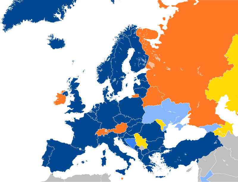
EU Association Agreements.svg
Hi Danlaycock. The map distinguishes between "Partnership and Cooperation Agreement; Association Agreement signed or under negotiations" and "Association Agreement under negotiations". Andorra and San Marino both have a "Cooperation agreement" with the EU. Is this significantly different to a Partnership and Cooperation Agreement? Monaco lacks this I think, so possibly it would be better to have "Cooperation Agreement; Association Agreement signed or under negotiations" (for PCA & CA) and "Association Agreement under negotiations" instead. Rob984 (talk) 14:10, 26 October 2015 (UTC)
- I'm not sure how similar the CAs are with the PCAs. Quite honestly, I think a lot of the titles are really just semantics and politics. Maybe it would be simpler if we split the map into two: one showing just the distinction between the different AAs (EEA/SAA/EMAA/AA) and those signed/under negotiation, and another map showing the other agreements, with no distinction between the various flavours of AA. It would certainly make the map easier to digest. TDL (talk) 23:07, 26 October 2015 (UTC)
ICC member states.svg
please update "ICC member states.svg" map, someone changed Russia but didn't change the African nations that left last month, thank you --DelftUser (talk) 13:03, 16 November 2016 (UTC)
- I think we should hold off until withdrawal is finalized. It takes one year from notification until withdrawal, so until late 2017 they will remain members. TDL (talk) 01:04, 17 November 2016 (UTC)
All Members?

What's about Abchasien, Arzach, Taiwan, Kosovo, Somaliland, Südossetien, Transnistrien, Nordzypern?--Bestoernesto (talk) 06:37, 19 November 2019 (UTC)
Do we need more legends like:
- non-EU member province, region, country or something else (Northern Ireland) with an opt-out
- non-EU member territory participating (Gibraltar)?
--Ärrännä (talk) 14:05, 2 January 2021 (UTC)
- I'd say we just colour it orange. Basically the UK is participating, but only for part of it's territory. So maybe we can add some language to the legend to clarity that.
- However, it looks like it will be 6M or so until they officialy join, so we should hold off until that happens. TDL (talk) 01:19, 4 January 2021 (UTC)
- It seems that the whole UK is still partially participating (opt-out) only they are no longer part of EU. There are also those member states (Croatia) that are becoming full members and are now partially participating --Ärrännä (talk) 06:47, 5 January 2021 (UTC)
I wait for you all
Yes sir I'm name ID card SOS ARIFIN am thank you very much my all sir am happy happy😁😁 078783434 0973060904 58.97.226.6 04:14, 25 December 2021 (UTC)
A map of Europe where Croatia needs fixing.
https://commons.wikimedia.org/wiki/File:Schengen_Area_Labelled_Map.svg HelpfulHens (talk) 12:55, 1 January 2023 (UTC)
Georgia and Ukraine
They should be the same colour as Bosnia here due to a link I will provide. https://upload.wikimedia.org/wikipedia/commons/thumb/0/0b/Major_NATO_affiliations_in_Europe.svg/800px-Major_NATO_affiliations_in_Europe.svg.png https://en.wikipedia.org/wiki/Enlargement_of_NATO#Current_status TBAG654321 (talk) 20:58, 24 February 2023 (UTC)
- No, you are mistaken. Neither Georgia nor Ukraine have Membership Action Plans from NATO like Georgia does. See: [1] TDL (talk) 00:00, 25 February 2023 (UTC)
Sweden, Finland and Kosovo
They need to be fixed on this page. https://upload.wikimedia.org/wikipedia/commons/a/ac/Current_and_former_neutral_countries_on_the_world_map.png TBAG654321 (talk) 21:16, 25 February 2023 (UTC)
Category change
https://en.wikipedia.org/wiki/Category:United_States_Minor_Outlying_Islands https://en.wikipedia.org/wiki/United_States_Minor_Outlying_Islands Both need the category "Dependent territories in North America" changing to "Dependent territories in the Caribbean" due to Navassa Island being in the Caribbean.TBAG654321 (talk) 22:28, 5 March 2023 (UTC)
Map of IAEA member states
Hi, thank you for your work on Wikipedia's maps. As for the map on Member_states_of_the_International_Atomic_Energy_Agency, do you think you could please add another color (blue?) to "observer states"? Palestine is an observer state of the IAEA (https://www.moroccoworldnews.com/2019/06/276239/iaea-recognition-palestine-controversy-israel). Thank you very much. Dan Palraz (talk) 11:02, 1 October 2023 (UTC)
+ Armenia
Armenia https://armenpress.am/eng/news/1121976.html 49.237.202.244 18:08, 21 October 2023 (UTC)
Update of File:CTBT Participation.svg
Hi! Since Russia revoked ratification of the treaty, File:CTBT Participation.svg needs an update - Russia in yellow as e.g., the US or in a special color. Could you do this? Regards, Michał Sobkowski (talk) 11:18, 7 November 2023 (UTC)
- @Michał Sobkowski: I've updated it now. TDL (talk) 19:32, 12 November 2023 (UTC)
Update of File:ICC member states.svg
Hi there. About your 27 November 2019 update of File:ICC member states.svg, I've noticed that you made two changes. You coloured El Salvador green, which was previously grey, and you added a red dot in Oceania which you said was supposed to represent Kiribati. I don't have anything to say about the El Salvador change, but about the Kiribati change, I'm afraid you're mistaken. Kiribati was already on the map: see the "triangle" of green dots northeast of New Guinea and the Solomon Islands? Well, Kiribati is the one on the bottom right. The one on the bottom left is Nauru, and the one at the top is the Marshall Islands. You can have a better view of this area on this picture here: https://en.wikipedia.org/wiki/Oceania#/media/File:Oceania_UN_Geoscheme_-_Map_with_Zones.svg. The red dot that you added is actually located between Tonga and Samoa and does not seem to correspond to any sovereign state (the rest of the states in the area are overseas possessions of other countries, therefore their participation (or lack of) in the ICC is dependent on their parent states). So I'm afraid this dot does not correspond to anything and should be removed. I would do it myself, but I don't know how to edit a picture :/ Thank you for your attention, and please let me know if you think I'm mistaken in my analysis. --Johnn Francis (talk) 00:18, 25 November 2023 (UTC)
- @Johnn Francis: I took a look at the image, and I actually made 3 changes: corrected the colours of El Salvador (grey=>green) and Kiribati (red=>green), and added a red dot for Niue, which like Cook Islands has been recognized by the UN as being able to independently ratify treaties. TDL (talk) 19:01, 12 December 2023 (UTC)
- You're right. I didn't notice that you had actually changed the colour of Kiribati from red to green, and you didn't mention Niue in your summary edit, so I mistakenly assumed that the red dot you had added was supposed to be Kiribati, which I thought you had incorrectly placed on the map. I also didn't know that Niue had a right to become a full-fledged member state of the ICC (even though it hasn't done so at the moment); I guess I should have read the "States parties to the Rome Statute" wikipedia article more carefully. As a matter of fact, the Cook Islands also have that right, and have actually exercised it, since unlike Niue they are a member of the ICC, and I've just realized they are actually shown on the map in the bottom left, which I hadn't even noticed until now. Anyway, that is just some utter fail on my part, so I'll try to be more careful next time :) Thank you for taking the time to reply to me, and I hope I didn't waste your time in the process. --Johnn Francis (talk) 22:23, 14 December 2023 (UTC)
Update request
Hello.
Can you update File:NATO PfP Members crop.svg, by coloring Finland and Sweden in green, because they became members of NATO?
Yours sincerely, 31.200.16.28 08:50, 8 April 2024 (UTC)
- Done. TDL (talk) 22:31, 8 April 2024 (UTC)
- Thank you very much. 31.200.16.28 05:27, 9 April 2024 (UTC)