Category:Pfarrkirche hl. Stephan, Krumbach
Jump to navigation
Jump to search
| Object location | | View all coordinates using: OpenStreetMap |
|---|
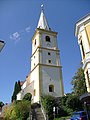
church building in Krumbach, Lower Austria _-_Kirche.JPG) Parish church of Krumbach, Lower Austria | |||||
| Upload media | |||||
| Instance of | |||||
|---|---|---|---|---|---|
| Named after | |||||
| Location | Krumbach, Wiener Neustadt District, Lower Austria, Austria | ||||
| Street address |
| ||||
| Architectural style | |||||
| Heritage designation | |||||
 | |||||
Media in category "Pfarrkirche hl. Stephan, Krumbach"
The following 6 files are in this category, out of 6 total.
-
 Krumbach (NÖ) - Kirche.JPG 3,201 × 4,800; 9.78 MB
-
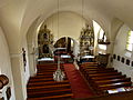 Krumbach Pfarrkirche Innenraum.JPG 4,320 × 3,240; 5.29 MB
-
 Krumbach Pfarrkirche.JPG 4,320 × 3,240; 5.53 MB
-
 Krumbach Pfarrkirche1.JPG 3,240 × 4,320; 5.17 MB
-
 Krumbach Pfarrkirche2.JPG 3,240 × 4,320; 5.31 MB
-
 Pfarrkirche hl Stephan Krummbach.JPG 2,304 × 3,072; 3.25 MB


