Category:Manbhum district
Jump to navigation
Jump to search
East Indian district during the British Raj | |||||
| Upload media | |||||
| Instance of |
| ||||
|---|---|---|---|---|---|
| Location |
| ||||
| Inception |
| ||||
| Dissolved, abolished or demolished date |
| ||||
| Population |
| ||||
| Area |
| ||||
| Follows |
| ||||
| Followed by | |||||
 | |||||
Subcategories
This category has only the following subcategory.
B
Media in category "Manbhum district"
The following 5 files are in this category, out of 5 total.
-
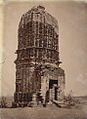
 Entrance to Durga Temple, Para, Manbhum District in 1872-73.jpg 712 × 917; 338 KB
-

-
 Manbhum (IA manbhum01coup).pdf 950 × 1,456, 324 pages; 21.15 MB
-

-