Category:17th-century maps of Lower Saxony
Jump to navigation
Jump to search
Federal states of Germany:
Subcategories
This category has the following 9 subcategories, out of 9 total.
- 1620s maps of Lower Saxony (1 F)
- 1630s maps of Lower Saxony (4 F)
- 1640s maps of Lower Saxony (12 F)
- 1650s maps of Lower Saxony (1 F)
1
Media in category "17th-century maps of Lower Saxony"
The following 29 files are in this category, out of 29 total.
-

-

-
 "Inferioris Saxoniae Circulus" (21637260073).jpg 3,627 × 2,988; 2.57 MB
-
 Frisiae, about 1600, by Ubbo Emmius.jpg 2,878 × 2,225; 1.71 MB
-
 Oude kaart Friesland.jpg 3,145 × 2,340; 5.42 MB
-
 1640 CIRCVLVS WESTPHALICUS Blaeu.jpg 2,500 × 1,937; 4.5 MB
-
 Unterweser Jadebusen 1643-48.jpg 7,518 × 3,132; 12.45 MB
-
 Joh Mejer Stormarn 1650.jpg 5,216 × 3,762; 19.05 MB
-

-

-

-
 Bawinkel-1673-Kartenausschnitt-Basse-Partie-De-Levessché-de-Munster.jpg 1,326 × 2,070; 866 KB
-
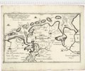
 Carlsburg - Erik Dahlberg - 1681.jpg 842 × 639; 339 KB
-
 Carlsburg - Jean Mell - 1695.jpg 842 × 600; 912 KB
-
 Circulus Saxoniae inferioris - CBT 5874008.jpg 5,715 × 4,750; 7.61 MB
-
 De merian Westphaliae 113.jpg 3,804 × 3,033; 3.52 MB
-
 Emda 1649 Blaeu.jpg 1,590 × 1,317; 544 KB
-
 Emden-1640-Merian.jpg 3,176 × 2,546; 2.32 MB
-
 Emderburg-1640-Merian.jpg 507 × 409; 158 KB
-
 Emmius-Karte von 1600 (Ausschnitt).jpg 677 × 854; 274 KB
-
 Fuerstentum-braunschweig-wolfenbuettel-1645-2.jpg 3,537 × 2,884; 14.69 MB
-
 Fuerstentum-braunschweig-wolfenbuettel-1645.jpg 4,402 × 3,692; 5.3 MB
-
 Karte von Ostfriesland.tif 3,532 × 2,937; 29.7 MB
-
 Nesserlander Höft - Martin Faber (ausschnit).jpg 641 × 410; 188 KB
-
 Nesserlanderhoeft.jpg 688 × 597; 282 KB
-
 Saxoniae Inferioris (Merian) b 020.jpg 3,507 × 2,845; 5.54 MB
-
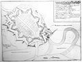
 Siege of Carlsburg 1676 (Print).jpg 874 × 1,134; 821 KB
-
 Siege of Carlsburg 1676.jpg 842 × 455; 304 KB
-
 Stadtplan von Emden 1641 (Merian).jpg 9,072 × 7,344; 19.54 MB
.jpg)
.jpg)
.jpg)


.jpg)
_Prov_Groningae_et_Omlandiae_tabula_(titel_op_object)_Geographische_beschrivinge_vande_pr_Stadt_Gr._en_Oml._vervattende_in_sich_alle_heerlyckheden,_fortressen,_dorpen,.jpg)


.jpg)


.jpg)

_b_020.jpg)
.jpg)

.jpg)