Category:Alexandria, West Dunbartonshire
Saltar para a navegação
Saltar para a pesquisa
town in West Dunbartonshire, Scotland, UK  | |||||
| Carregar ficheiro | |||||
| Instância de | |||||
|---|---|---|---|---|---|
| Localização |
| ||||
| População |
| ||||
 | |||||

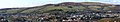
Alexandria (Cathair Alastair in Gaelic) is a town in West Dunbartonshire, Scotland. The town is situated on the River Leven, four miles (6 km) north-west of Dumbarton.
Subcategorias
Esta categoria contém as seguintes 22 subcategorias (de um total de 22).
A
- Alexandria railway station (8 F)
- Argyll Motor Works (34 F)
B
- Black Bridge, Alexandria (2 F)
- Bonhill Bridge (9 F)
- Burnbrae Tunnel (3 F)
C
- Christie Park, Alexandria (7 F)
F
- Ferry Loan, Alexandria (3 F)
I
- India Street, Alexandria (2 F)
L
M
- Main Street, Alexandria (10 F)
- Millburn Park, Alexandria (3 F)
O
- Overton Road bridge (2 F)
S
V
- Vale of Leven Academy (5 F)
- Vale of Leven cemetery (2 F)
- Vale of Leven Hospital (3 F)
Multimédia na categoria "Alexandria, West Dunbartonshire"
Esta categoria contém os seguintes 71 ficheiros (de um total de 71).
-
 Alexandria - geograph.org.uk - 396544.jpg 640 × 355; 79 kB
-
 Alexandria from above Bonhill - geograph.org.uk - 359340.jpg 640 × 118; 34 kB
-
 Alexandria Methodist Church - geograph.org.uk - 3250186.jpg 1 024 × 683; 311 kB
-
 Alexandria Parish Church - geograph.org.uk - 3290238.jpg 1 024 × 585; 224 kB
-
 Alexandria Parish Churchyard - geograph.org.uk - 3239496.jpg 640 × 480; 128 kB
-
 Alexandria ROC Bunker, access shaft - geograph.org.uk - 3028028.jpg 1 024 × 640; 279 kB
-
 Alexandria ROC Bunker, FSM mount - geograph.org.uk - 3028006.jpg 1 024 × 768; 384 kB
-
 Alexandria ROC Bunker, GZI mount - geograph.org.uk - 3028058.jpg 1 024 × 768; 290 kB
-
 Alexandria Waterworks Dam - geograph.org.uk - 374610.jpg 640 × 390; 68 kB
-
 Alexandria, SCO, Smollet Street.jpg 3 000 × 2 000; 4,54 MB
-
 Allan Crescent Alexandria - geograph.org.uk - 389084.jpg 640 × 427; 63 kB
-
 Antartex Village - geograph.org.uk - 250467.jpg 640 × 479; 42 kB
-
 Creveul Court, Alexandria - geograph.org.uk - 2198016.jpg 640 × 480; 78 kB
-
 Edwardian pillar box - geograph.org.uk - 1062310.jpg 480 × 640; 74 kB
-
 Ferryfield Gardens, Alexandria - geograph.org.uk - 2195978.jpg 640 × 400; 54 kB
-
 Former Alexandria Parish Church - geograph.org.uk - 3250287.jpg 1 024 × 787; 463 kB
-
 Former Alexandria Parish Church - geograph.org.uk - 3250336.jpg 1 024 × 512; 302 kB
-
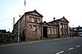
 Former public hall, Alexandria - geograph.org.uk - 2195890.jpg 1 024 × 1 024; 225 kB
-
 Former public hall, Alexandria - geograph.org.uk - 3211407.jpg 1 600 × 1 200; 329 kB
-
 Gilmour Institute Alexandria - geograph.org.uk - 366713.jpg 640 × 426; 95 kB
-
 Gilmour Street Alexandria - geograph.org.uk - 366717.jpg 640 × 426; 101 kB
-
 Gilmour Street in Alexandria SCO.jpg 3 000 × 2 000; 4,97 MB
-
 Housing in Alexandria - geograph.org.uk - 1074135.jpg 640 × 480; 165 kB
-
 Leaf galls on alder - geograph.org.uk - 992685.jpg 640 × 480; 82 kB
-
 Leaf galls on nettle - geograph.org.uk - 973028.jpg 640 × 480; 70 kB
-
 Looking north on Luss Road - geograph.org.uk - 1071104.jpg 640 × 480; 101 kB
-
 Luss Road, Alexandria - geograph.org.uk - 2197966.jpg 640 × 640; 109 kB
-
 Masonic Temple Alexandria.jpg 3 000 × 2 000; 4,34 MB
-
 Middleton Street Alexandria - geograph.org.uk - 359375.jpg 640 × 480; 72 kB
-
 Middleton Street, Alexandria - geograph.org.uk - 2196009.jpg 640 × 337; 60 kB
-
 Mitchell Way, Alexandria - geograph.org.uk - 1074064.jpg 640 × 480; 124 kB
-
 North Street, Alexandria - geograph.org.uk - 2198037.jpg 640 × 320; 64 kB
-
 Nursery in Alexandria - geograph.org.uk - 1071096.jpg 640 × 480; 105 kB
-
 Old Post Office Dental Practice - geograph.org.uk - 1074070.jpg 640 × 480; 133 kB
-
 Ordnance Survey One-inch Sheet 60 Glasgow, Published 1957.jpg 8 171 × 9 912; 12,02 MB
-
 Ordnance Survey One-Inch Sheet 60 Glasgow, Published 1965.jpg 8 238 × 9 844; 13,58 MB
-
 Ordnance Survey One-Inch Sheet 66 Loch Lomond, Published 1945.jpg 9 716 × 7 430; 9,61 MB
-

-
 Overton Farmhouse - geograph.org.uk - 374615.jpg 640 × 480; 110 kB
-
 Park Street, Alexandria - geograph.org.uk - 3336378.jpg 1 024 × 576; 356 kB
-
 Public house in Alexandria - geograph.org.uk - 1071124.jpg 640 × 480; 119 kB
-
 Pyramid with Bonhill Bridge plaque - geograph.org.uk - 1110872.jpg 480 × 640; 116 kB
-
 Queen Street Alexandria - geograph.org.uk - 374627.jpg 640 × 480; 71 kB
-
 Railway bridge at Bridge Street Alexandria - geograph.org.uk - 1956723.jpg 1 280 × 853; 383 kB
-
 Railway bridge at Bridge Street Alexandria - geograph.org.uk - 1956728.jpg 1 280 × 779; 216 kB
-
 Railway lines by the B857 - geograph.org.uk - 1074140.jpg 640 × 480; 121 kB
-
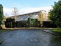 Remnants of the Alexandria Works - geograph.org.uk - 3240531.jpg 640 × 480; 202 kB
-
 Remnants of the Alexandria Works - geograph.org.uk - 3290026.jpg 587 × 640; 107 kB
-
 River Leven Alexandria - geograph.org.uk - 366704.jpg 640 × 426; 115 kB
-
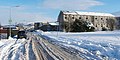
 Road into Alexandria - geograph.org.uk - 1074144.jpg 640 × 480; 127 kB
-
 Rossbank Farm (geograph 2408716).jpg 640 × 400; 59 kB
-
 Royal Observer Corps Monitoring Post, Alexandria - geograph.org.uk - 3027995.jpg 1 024 × 768; 220 kB
-
 Royal Observer Corps Monitoring Post, Alexandria - geograph.org.uk - 3028072.jpg 1 024 × 853; 272 kB
-
 Smollett Street, Alexandria - geograph.org.uk - 2198633.jpg 1 600 × 800; 270 kB
-
 Start of track to Asker Farm - geograph.org.uk - 1552726.jpg 640 × 480; 116 kB
-
 Surgery in Alexandria - geograph.org.uk - 1074059.jpg 640 × 480; 150 kB
-
 Susannah Street, Alexandria - geograph.org.uk - 2196825.jpg 640 × 356; 59 kB
-
 The base of a tree - geograph.org.uk - 1282799.jpg 640 × 480; 118 kB
-
 The edge of the woods - geograph.org.uk - 1283348.jpg 640 × 480; 106 kB
-
 Thomas Street flats - geograph.org.uk - 1479533.jpg 640 × 480; 94 kB
-
 Tributary stream of River Leven - geograph.org.uk - 1074212.jpg 640 × 480; 175 kB
-
 Upper Bridge Street Alexandria - geograph.org.uk - 374633.jpg 640 × 480; 71 kB
-
 Various signs by Luss Road - geograph.org.uk - 1071086.jpg 640 × 480; 126 kB
-
 Victorian Postbox - geograph.org.uk - 1045057.jpg 480 × 640; 111 kB
-
 View of Bank Alexandria - geograph.org.uk - 1956663.jpg 1 280 × 853; 272 kB
-
 War Memorial at Alexandria Parish Church - geograph.org.uk - 3290263.jpg 1 200 × 1 600; 906 kB
-
 War Memorial at Alexandria Parish Church - geograph.org.uk - 3290284.jpg 768 × 1 024; 460 kB
-
 Warehouse Staining Fungus - geograph.org.uk - 971102.jpg 640 × 480; 136 kB
-
 Woodland stream - geograph.org.uk - 1282404.jpg 640 × 480; 128 kB
-
 Woodland, Tullichewan - geograph.org.uk - 723886.jpg 640 × 480; 140 kB
-
 Wylie Avenue, Alexandria - geograph.org.uk - 1074165.jpg 640 × 480; 120 kB


.jpg)


