Category:Arikara
Aller à la navigation
Aller à la recherche
tribu amérindienne | |||||
| Téléverser des médias | |||||
| Nature de l’élément | |||||
|---|---|---|---|---|---|
| |||||
Sous-catégories
Cette catégorie comprend 3 sous-catégories, dont les 3 ci-dessous.
Média dans la catégorie « Arikara »
Cette catégorie comprend 96 fichiers, dont les 96 ci-dessous.
-
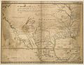 1721 Map of the new part of French Louisiana.jpg 8 104 × 6 291 ; 14,19 Mio
-
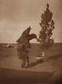
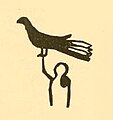 An Arikara catching an eagle.jpg 384 × 408 ; 54 kio
-
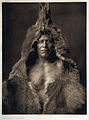
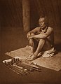
 An Arikara Indian, by Edward Sheriff Curtis.jpg 1 698 × 3 032 ; 931 kio
-
 An Arrikara warrior 0027v.jpg 2 584 × 3 482 ; 2,07 Mio
-
 Arikara Beadwork (27143943173).jpg 2 365 × 4 553 ; 7,31 Mio
-
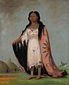
 Arikara chief Son of the Star.jpg 636 × 1 212 ; 266 kio
-
 Arikara Girl, 1908.jpg 506 × 768 ; 123 kio
-
 Arikara Indian Scout Post No 1, Fort Berthold Indian Reservation, North Dakota.jpg 1 415 × 982 ; 628 kio
-
 Arikara Indian scout Soldier (cropped).jpg 839 × 1 333 ; 728 kio
-
 Arikara Indian scout Soldier.jpg 865 × 1 424 ; 752 kio
-
 Arikara Indian scout Strikes Two (cropped).jpg 823 × 1 336 ; 847 kio
-
 Arikara Indian scout Strikes Two.jpg 867 × 1 409 ; 1 023 kio
-

-
 Arikara lang.png 501 × 321 ; 29 kio
-
 Arikara language map.png 501 × 321 ; 39 kio
-
 Arikara Medicine Ceremony -The Ducks (5711526012).jpg 1 380 × 2 000 ; 677 kio
-
 Arikara medicine fraternity.jpg 640 × 494 ; 32 kio
-
 Arikara movements 1795-1862.png 2 036 × 2 581 ; 1,07 Mio
-
 Arikara movements, 1795 to 1862.png 1 776 × 2 502 ; 7,43 Mio
-

-
 Arikara Villages, 1823-1886, PNG file.png 1 076 × 863 ; 1 022 kio
-
 Arikara, Hidatsa and Mandan 1851 treaty territory. (Area 529, 620 and 621 south of the Missouri).png 1 012 × 1 050 ; 2,06 Mio
-

-

-
 Battlefields (approx.) - U.S. Army and Lakotas, 1854-1890.png 500 × 371 ; 298 kio
-
 Battlefields between the Lakotas and the U.S. Army from 1854 to 1890 (approx.).png 2 485 × 2 790 ; 14,1 Mio
-
 Bear's Belly - Arikara, 1909.jpg 567 × 768 ; 138 kio
-
 Bear's Belly by Edward Curtis, 1908.jpg 3 335 × 4 492 ; 1,46 Mio
-
 Bozeman Trail, the forts and the Indian territories.jpg 1 720 × 2 052 ; 458 kio
-
 Brothers Wet Plate Collodion with Allan Demaray by Shane Balkowitsch.jpg 6 368 × 8 544 ; 22,62 Mio
-
 Bulletin (1907) (20238422968).jpg 436 × 496 ; 80 kio
-
 Cloud-Shield's winter count (Lakota). 1823-24. The Arikara War.png 392 × 484 ; 151 kio
-
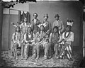
 Dakota, Hidatsa, and Arikara delegation - NARA - 523687.jpg 3 000 × 2 249 ; 1,47 Mio
-
 De Smet map, 1851. Detail with the Indian Territories from the Fort Laramie Treaty, 1851.png 1 629 × 2 005 ; 5,34 Mio
-
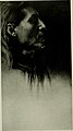
 Edward S. Curtis Collection People 042.jpg 674 × 1 024 ; 108 kio
-
 Flag of the Mandan, Hidatsa & Arikara Nation.png 474 × 282 ; 13 kio
-
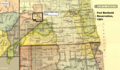
 Fort Berthold Reservation (1 of 5) tekst.png 1 897 × 1 104 ; 3,41 Mio
-
 Fort Berthold Reservation (2 of 5).png 1 897 × 1 104 ; 3,46 Mio
-
 Fort Berthold Reservation (3 of 5).png 1 897 × 1 104 ; 3,47 Mio
-
 Fort Berthold Reservation (4 of 5).png 1 897 × 1 104 ; 3,47 Mio
-
 Fort Berthold Reservation (5 of 5).png 1 897 × 1 104 ; 3,45 Mio
-
 Fort Berthold Reservation after the construction of Garrison Dam.png 968 × 689 ; 975 kio
-
 Fort Laramie Treaty, 1851, printed in Kappler, vol. 2, page 596.png 1 006 × 1 524 ; 2,16 Mio
-

-

-

-

-

-
-

-
 Hidatsa01.png 903 × 1 047 ; 1,3 Mio
-
 Image from page 101 of "Bulletin" (1901).jpg 832 × 1 330 ; 381 kio
-
 In the Medicine Lodge - Arikara.jpg 2 430 × 3 348 ; 5,23 Mio
-

-
 Interior of an Arikara ceremonial lodge.png 1 328 × 1 032 ; 1,44 Mio
-
 Knife River Indian Villages National Historic Site (25c0ffca-47ea-4343-82ca-756c5fa576d7).jpg 2 037 × 2 448 ; 620 kio
-
 Knife River Indian Villages National Historic Site (73c8b3c5-38c2-4f16-8c2a-32f31a0dc6ef).jpg 3 264 × 2 448 ; 1,1 Mio
-
 Knife River Indian Villages National Historic Site (7c95596a-11f8-45fa-ba5b-9665ca2e011f).jpg 3 264 × 2 448 ; 998 kio
-
 Knife River Indian Villages National Historic Site (9febb443-a91c-4f7d-96e6-a64b87f385ce).jpg 3 264 × 1 565 ; 625 kio
-
 Knife River Indian Villages National Historic Site (a2e49de6-b8e9-44de-aea5-45b7c0218fc1).jpg 3 264 × 2 052 ; 813 kio
-
 Knife River Indian Villages National Historic Site (a78e9990-e1b0-41b3-b206-d8f50222a0f6).jpg 2 448 × 1 891 ; 894 kio
-
 Knife River Indian Villages National Historic Site (b250ed04-e4f9-47bf-9ab7-f62c20453165).jpg 3 263 × 1 514 ; 531 kio
-
 Knife River Indian Villages National Historic Site (bd6b7880-cd90-47e9-948b-cde0d24ccbe3).jpg 3 215 × 1 625 ; 587 kio
-
 Knife River Indian Villages National Historic Site (c4a216be-6604-46b7-936f-b7b15bdcd361).jpg 3 264 × 2 448 ; 1,15 Mio
-
 Knife River Indian Villages National Historic Site (c563f44e-0e50-4e61-a008-022b1e17dc7b).jpg 3 264 × 2 448 ; 1,16 Mio
-
 Knife River Indian Villages National Historic Site (c977a82c-23cd-4abb-9f00-bc93252a3f70).jpg 3 264 × 2 448 ; 864 kio
-
 Knife River Indian Villages National Historic Site (e16a3c9a-d540-467c-8658-f9546aefadca).jpg 1 954 × 2 601 ; 752 kio
-
 Knife River Indian Villages National Historic Site (f2adea14-e665-4e2b-b063-5c5e52839ee7).jpg 3 264 × 2 448 ; 952 kio
-
 Larson -, Spiry-Eklo - and Travis 2 Site in Wolworth County, South Dakota.png 2 031 × 2 192 ; 2,56 Mio
-
 Leadership Shirt MET DT255981.jpg 2 000 × 1 600 ; 2,13 Mio
-
 Like A Fishhook Village, Fort Berthold Indian Reservation, North Dakota.png 1 502 × 914 ; 2 Mio
-
 Like-a-Fishhook Village and the rising water in Lake Sakakawea.png 901 × 729 ; 1,14 Mio
-
 Mandan and Arikara delegation - NARA - 523669.jpg 3 000 × 2 407 ; 1,45 Mio
-
 Mandan, hidatsa o arikara, camicia da uomo, 1890 ca.jpg 3 344 × 1 672 ; 3,84 Mio
-
 Map of 32ML2 Like-a-Fishhook Village, Fort Berthold 1 and 2 and vicinity.png 1 092 × 795 ; 921 kio
-
 Map of Star Village (32ME16), North Dakota.jpg 1 718 × 1 075 ; 535 kio
-

-
 Native American Man Wearing a Bear Claw Necklace (b98429c04d404722bf21045164a91bbf).tif 4 864 × 5 986 ; 83,3 Mio
-
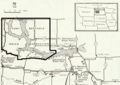
 NorthDakotaFirstNation.jpg 1 344 × 552 ; 183 kio
-
 Prayer to the Cedar - Arikara.jpg 2 436 × 3 330 ; 5,27 Mio
-
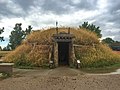
 Ree Indian Lodge.png 1 437 × 1 397 ; 815 kio
-
 Reid gomez niki lee.jpg 297 × 432 ; 146 kio
-
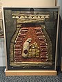
 Shield, Arikara, North Dakota, c. 1850 - Nelson-Atkins Museum of Art - DSC09071.JPG 2 707 × 3 922 ; 3,81 Mio
-
 Site of the Arikara village Star Village (32ME16), N.D.png 1 354 × 1 474 ; 2,48 Mio
-
 Some Arikara Indian villages and military forts in the Dakotas, 1795-1886.png 1 123 × 1 294 ; 2,13 Mio
-
 Some Arikara villages - 1700-1885.jpg 1 833 × 1 797 ; 360 kio
-
 Some Indian villages burned by the Sioux, cirka 1780-1862.png 1 642 × 1 509 ; 1,93 Mio
-
 The American Museum journal (c1900-(1918)) (18156582402).jpg 3 040 × 2 204 ; 1,9 Mio
-
 The De Lestry map of Larson Site (39WW2), Walworth County, South Dakota (2).png 908 × 700 ; 201 kio
-
 The dogs Death and Sickness for ever following the Arikara.png 870 × 578 ; 715 kio
-
 The Lakota Wars (1854-1890). The battlefields and the Lakota treaty territory of 1851 (circa.).png 2 070 × 2 500 ; 1,43 Mio
-
 The Phillips Ranch site, South Dakota.png 1 011 × 1 314 ; 1,99 Mio
-

-
 View across the Missouri River at New Town, North Dakota- Fort Berthold.JPG 640 × 480 ; 56 kio
-
 View of the Four Bears Bridge, Fort Berthold Reservation, North Dakota.JPG 640 × 480 ; 65 kio
-
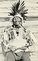
 White Shield, half-length portrait, facing left circa 1908.jpg 820 × 1 024 ; 115 kio


.jpg)


.jpg)

.jpg)


.jpg)


_from_Illustrations_of_the_manners,_customs,_and_condition_of_the_North_American_Indians._(1866_ed.).jpg)

.png)

_-_U.S._Army_and_Lakotas,_1854-1868_(blue_x)_and_1869-1890_(red_x).png)
_-_U.S._Army_and_Lakotas,_1854-1890.png)
.png)


_(20238422968).jpg)
._1823-24._The_Arikara_War.png)


_tekst.png)
.png)
.png)
.png)
.png)


.jpg)


.jpg)

).png)

.jpg)
.jpg)
.jpg)
.jpg)
.jpg)
.jpg)
.jpg)
.jpg)
.jpg)
.jpg)
.jpg)
.jpg)
.jpg)


,_North_Dakota.jpg)
_(14596451109).jpg)


,_N.D.png)


)_(18156582402).jpg)
,_Walworth_County,_South_Dakota_(2).png)

._The_battlefields_and_the_Lakota_treaty_territory_of_1851_(circa.).png)

_and_Cloud_Shield_(II).png)


