Category:Auma
Navigatsiya qismiga oʻtish
Qidirish qismiga oʻtish
Deutsch: Auma ist ein Ortsteil der Stadt Auma-Weidatal im thüringischen Landkreis Greiz. Er liegt etwa 20 km südwestlich von Gera.
English: Auma is a municipal subdivision of Auma-Weidatal in the district of Greiz, in Thuringia, Germany. It is situated 24 km southwest of Gera.
Nederlands: Auma is een onderdeel van de landgemeente Auma-Weidatal in de Duitse deelstaat Thüringen, gelegen in het district Greiz. De stad heeft ongeveer 3300 inwoners.
district of Auma-Weidatal, Germany   | |||||
| Fayl yuklash | |||||
| Bu konsepsiyaning alohida holati |
| ||||
|---|---|---|---|---|---|
| Location | Auma-Weidatal, Greiz, Turingiya, Germaniya | ||||
| Aholisi |
| ||||
| Hudud |
| ||||
| Dengiz sathidan balandligi |
| ||||
| ...dan farqli | |||||
| rasmiy vebsayti | |||||
 | |||||
Ostturkumlar
Quyida ushbu turkumga kiruvchi 13 ta ostturkumdan 13 tasi koʻrsatilgan.
B
- Bahnhof Auma (2 F)
F
- Freiwillige Feuerwehr Auma (2 F)
H
L
- Liebfrauenkirche (Auma) (4 F)
- LPG Auma (1 F)
M
- Maibaum Auma (9 F)
P
- Postmeilensäule in Auma (14 F)
R
- Rathaus Auma (10 F)
S
- Sealing stamps of Auma (8 F)
W
- Windmill in Auma (4 F)
„Auma“ turkumidagi fayllar
Quyida ushbu turkumga kiruvchi 9 ta fayldan 9 tasi koʻrsatilgan.
-
De-Auma.ogg 1,5 soniya; 15 KB
-
 Auma in GRZ.png 299 × 299; 5 KB
-
 Auma-Weidatal, Germany - panoramio (25).jpg 5 178 × 3 596; 2,15 MB
-
 Auma-Weidatal, Germany - panoramio (9).jpg 5 056 × 3 371; 1,75 MB
-
 AumaStM.jpg 640 × 465; 41 KB
-
 Bushaltestelle Auma, Anker.jpg 3 072 × 2 304; 4,1 MB
-
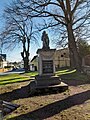 Gefallenendenkmal Auma.jpg 3 000 × 4 000; 4,87 MB
-
 Wappen Auma.png 172 × 197; 6 KB
-
 Weißes Tablett (31).jpg 4 013 × 2 713; 2,76 MB

.jpg)
.jpg)


.jpg)