Category:Bathymetry
Zur Navigation springen
Zur Suche springen

Vermessung der topographischen Gestalt der Gewässerbetten und Meeresböden  | |||||
| Medium hochladen | |||||
| Aussprache (Audiodatei) | |||||
|---|---|---|---|---|---|
| Unterklasse von | |||||
| Verschieden von | |||||
| |||||
Unterkategorien
Es werden 10 von insgesamt 10 Unterkategorien in dieser Kategorie angezeigt:
In Klammern die Anzahl der enthaltenen Kategorien (K), Seiten (S), Dateien (D)
Medien in der Kategorie „Bathymetry“
Folgende 45 Dateien sind in dieser Kategorie, von 45 insgesamt.
-
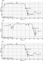
 2019-03-08-Mayotte Bathymetry-EW-profile.png 650 × 297; 17 KB
-
 BAG.png 256 × 256; 78 KB
-
 Bathymetric sections over Philippine Trench.png 2.396 × 3.393; 106 KB
-
 Bathymetry profile along Fugro Discovery's survey line.jpg 3.600 × 1.821; 2,1 MB
-

-
 Expl2368 - Flickr - NOAA Photo Library.jpg 3.072 × 2.304; 774 KB
-
 FM Tree Raster Figure 1.jpeg 782 × 752; 199 KB
-
 Grunnslep fra 1930.jpg 3.010 × 3.826; 824 KB
-
 Grunnslep fra 1930.png 3.074 × 4.042; 35,56 MB
-
 Grunnslep fra 1932.jpg 3.071 × 3.210; 492 KB
-
 Grunnslep fra 1932.png 3.462 × 3.609; 35,76 MB
-
 LARGE elevation-1080x1080-animated72steps.gif 545 × 545; 7,71 MB
-
 Mavericks wave diagram.gif 2.405 × 3.089; 1,77 MB
-
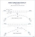
Morphometry-of-Concepcion-Bank-Evidence-of-Geological-and-Biological-Processes-on-a-Large-Volcanic-pone.0156337.s006.ogv 1 min 7 s, 720 × 480; 7,71 MB
-
 OCEAN AND SHORE 2-a.jpg 700 × 488; 109 KB
-
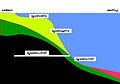
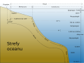
 Oceanic basin it.png 800 × 563; 39 KB
-
 Oceanic basin nl.svg 1.001 × 705; 31 KB
-
 Oceanic basin oc.png 1.001 × 705; 83 KB
-
 Oceanic basin pl.svg 1.001 × 705; 31 KB
-
 Oceanic basin ru.svg 1.001 × 705; 32 KB
-
 Oceanic basin tr.svg 1.001 × 705; 40 KB
-
 Oceanic basin uk.svg 1.001 × 705; 32 KB
-
 Oceanic basin-ar.svg 1.001 × 705; 104 KB
-
 Oceanic basin-fr.svg 1.001 × 705; 61 KB
-
 Oceanic basin-sv.svg 1.001 × 705; 32 KB
-
 Oceanic basin.svg 1.001 × 705; 9 KB
-
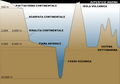
 Oceanic divisions es.svg 1.114 × 835; 23 KB
-
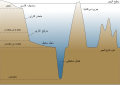
 Oceanic divisions pl.svg 1.114 × 835; 44 KB
-
 Oceanic divisions ru.svg 1.114 × 835; 43 KB
-
 Oceanic divisions uk.svg 1.114 × 835; 43 KB
-
 Oceanic divisions-fr.svg 1.114 × 835; 51 KB
-
 Oceanic divisions-ja.svg 1.114 × 835; 55 KB
-
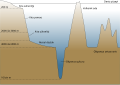
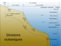
 Oceanic divisions.svg 1.114 × 835; 12 KB
-
 Oceanic-basin-th.png 1.001 × 705; 100 KB
-
 Oceanic-basin-th.svg 1.001 × 705; 38 KB
-
 Oceanic.Stripe.Magnetic.Anomalies.Scheme.fr.gif 260 × 190; 17 KB
-
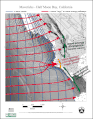
 OpenSeaMap water depths by drowdsourcing-de.jpg 960 × 720; 68 KB
-
 Philippine plate tectonics - selected profiles.png 1.415 × 2.511; 185 KB
-
 Propagating Rift - Morphological Signature.png 1.616 × 544; 1,77 MB
-
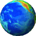 Rotating globe s.gif 139 × 139; 1,91 MB
-
 ROYAL NAVY SURVEY SHIP SPOTS UNDERWATER MOUNTAINS MOD 45158386.jpg 840 × 601; 282 KB
-
 Screenshot OpenSeaMap AT5-Karte Neustadt Lowrance Elite Ti 7.png 800 × 480; 186 KB
-
 Sea floor topography.gif 193 × 193; 288 KB
-
 Sediment echosounder hg.png 1.000 × 702; 1,07 MB
-
 Europas Kolonien. 1 1885 (150827201).jpg 3.461 × 5.001; 10,26 MB


_Pacific_Oceanographic_Laboratories_(1968)_(20656430742).jpg)


.jpg)