Category:Beaverhead County, Montana
Sari la navigare
Sari la căutare
Counties of Montana: Beaverhead · Big Horn · Blaine · Broadwater · Carbon · Carter · Cascade · Chouteau · Custer · Daniels · Dawson · Deer Lodge · Fallon · Fergus · Flathead · Gallatin · Garfield · Glacier · Golden Valley · Granite · Hill · Jefferson · Judith Basin · Lake · Lewis and Clark · Liberty · Lincoln · Madison · McCone · Meagher · Mineral · Missoula · Musselshell · Park · Petroleum · Phillips · Pondera · Powder River · Powell · Prairie · Ravalli · Richland · Roosevelt · Rosebud · Sanders · Sheridan · Silver Bow · Stillwater · Sweet Grass · Teton · Toole · Treasure · Valley · Wheatland · Wibaux · Yellowstone
comitat din Statele Unite ale Americii  Здание окружного суда в Диллоне, Монтана  | |||||
| Încarcă multimedia | |||||
| Este un/o | |||||
|---|---|---|---|---|---|
| Numit(ă) după |
| ||||
| Locul actual | Montana, SUA | ||||
| Capitală | |||||
| Înființare |
| ||||
| Populație |
| ||||
| Suprafață |
| ||||
| site oficial | |||||
 | |||||
Subcategorii
Această categorie conține următoarele 17 subcategorii, dintr-un total de 17.
Fișiere media din categoria „Beaverhead County, Montana”
Următoarele 33 fișiere se află în această categorie, dintr-un total de 33.
-
 Beaver Head county high.jpg 3.504x2.336; 3,63 MB
-
 Beaverhead Mountains.jpg 4.032x3.024; 3,74 MB
-
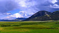
 Berry Meadow.jpg 2.848x1.602; 1,89 MB
-
 Brower's Spring August 2016.jpg 2.988x5.312; 6,87 MB
-

-
 Dillon Montana.jpg 720x540; 70 KB
-
 Eastern Pioneer Range MT.jpg 1.280x960; 105 KB
-
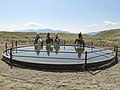 EQIP2 (23991954237).jpg 4.000x3.000; 4,89 MB
-
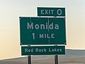 Exit 0 sign on I-15 north of Montana-Idaho state line.jpg 4.512x3.408; 7,82 MB
-
 Livestock1.JPG (38844618262).jpg 2.936x1.208; 1,27 MB
-
 Log Cabin Jump Maverick MT.jpg 1.280x960; 67 KB
-
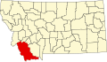 Map of Montana highlighting Beaverhead County.svg 9.194x5.303; 122 KB
-
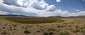
 Monida, Montana.jpg 800x406; 32 KB
-
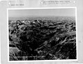 Montana - Red Lodge through Twin Lakes - NARA - 23941959.jpg 4.385x3.382; 2,92 MB
-
 Montana - Red Lodge through Twin Lakes - NARA - 23941961.jpg 4.385x3.382; 3,42 MB
-
-

-
-

-
 MTMap-doton-Lima.PNG 300x175; 12 KB
-
 Near-horse-prairie-sw-montana-july-2010-roger-peterson-002 (5623243718).jpg 3.005x1.892; 1,5 MB
-

-
 Npnht-grasshopper-creek-bannack-montana-082011-rogermpeterson-001 (6819443180).jpg 4.288x2.848; 3,27 MB
-
 Npnht-pelicans-clark-canyon-reservior-07102012-rogermpeterson-005 (7645615842).jpg 2.802x3.356; 2,53 MB
-

-
 NRCSMT01004 - Montana (4859)(NRCS Photo Gallery).jpg 1.500x2.100; 5,98 MB
-
 NRCSMT01006 - Montana (4863)(NRCS Photo Gallery).jpg 2.100x1.500; 6,17 MB
-
 NRCSMT01006 - Montana (4863)(NRCS Photo Gallery).tif 2.100x1.500; 12,02 MB
-
 NRCSMT01026 - Montana (4901)(NRCS Photo Gallery).tif 1.500x2.100; 12,02 MB
-
 Red Rock Lakes NWR Entrance.jpg 3.766x2.634; 1,05 MB
-
 Upper Red Rock Lake and Centennial Mountains.jpg 1.024x576; 304 KB
-
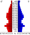 USA Beaverhead County, Montana age pyramid.svg 520x600; 8 KB
-
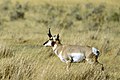 Wildlife59 (39046240852).jpg 2.250x1.500; 4,64 MB


.jpg)


.jpg)
.jpg)
.jpg)


.jpg)
.jpg)
.jpg)
.jpg)
.jpg)
(NRCS_Photo_Gallery).jpg)
(NRCS_Photo_Gallery).jpg)


.jpg)
.jpg)