Category:Bilston
Aller à la navigation
Aller à la recherche
English: Bilston is a town in England's West Midlands region. It is situated in the south-eastern corner of the City of Wolverhampton. Three wards of Wolverhampton City Council cover the town: Bilston East and Bilston North, which almost entirely comprise parts of the historic Borough of Bilston, and Ettingshall which comprise a part of Bilston and parts of Wolverhampton.
Polski: Bilston - miasto w Wielkiej Brytanii, w Anglii, w regionie West Midlands, w hrabstwie West Midlands. W 2001 r. miasto to zamieszkiwało 24 300 osób.
Română: Bilston este actualmente numele unei zone din oraşului Wolverhampton în comitatul West Midlands, regiunea West Midlands, Anglia. Oraşul s-a dezvoltat la sfârşitul secoulului XIX, şi a obţinut titlul de oraş în 1933. În 1966, pin urma unei reforme administrative oraşul a fost integrat în totalitate în oraşul Wolverhampton.
localité britannique  | |||||
| Téléverser des médias | |||||
| Nature de l’élément | |||||
|---|---|---|---|---|---|
| Lieu | Wolverhampton, Midlands de l'Ouest, Angleterre | ||||
 | |||||
Sous-catégories
Cette catégorie comprend 8 sous-catégories, dont les 8 ci-dessous.
B
C
- Car parks in Bilston (8 F)
E
- Bilston enamel (12 F)
H
- Hickman Park, Bilston (9 F)
P
- Peascroft Wood (14 F)
T
- Three Columns (Miles Davis) (3 F)
Média dans la catégorie « Bilston »
Cette catégorie comprend 132 fichiers, dont les 132 ci-dessous.
-
 "Elisabeth" blast furnace, Bilston, 1965 - geograph.org.uk - 1629193.jpg 640 × 480 ; 74 kio
-

-
 1st Bilston Scouts - geograph.org.uk - 387773.jpg 640 × 480 ; 148 kio
-

-
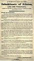 A Warning Voice to the Inhabitants of Bilston.jpg 500 × 893 ; 255 kio
-
 And you thought they were all like this^ - geograph.org.uk - 833557.jpg 640 × 480 ; 90 kio
-
 Approximate location of the pathway atop the mound at Bilston.jpg 3 984 × 2 988 ; 2,97 Mio
-
 Arthur Greenwood Court - geograph.org.uk - 930112.jpg 480 × 640 ; 72 kio
-
 Baths and wash-houses, Bilston, near Birmingham; with a plan Wellcome L0014743.jpg 1 098 × 1 694 ; 441 kio
-
 Bilston Army Cadets - geograph.org.uk - 830566.jpg 640 × 480 ; 103 kio
-
 Bilston C of E Primary School - geograph.org.uk - 930097.jpg 640 × 480 ; 98 kio
-
 Bilston Castle east pathway.jpg 640 × 480 ; 167 kio
-
 Bilston Fire Station - geograph.org.uk - 675065.jpg 640 × 480 ; 89 kio
-
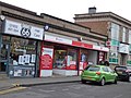
 Bilston High Street.JPG 720 × 480 ; 302 kio
-
 Bilston Lawn Tennis Club - geograph.org.uk - 930047.jpg 640 × 480 ; 58 kio
-
 Bilston McDonald's - geograph.org.uk - 1019084.jpg 640 × 480 ; 72 kio
-
 Bilston Mecca - geograph.org.uk - 988393.jpg 640 × 480 ; 52 kio
-
 Bilston Post Office - Hall Street, Bilston - new post office (39687183181).jpg 4 608 × 3 456 ; 2,19 Mio
-
 Bilston Promoted 2013.jpg 383 × 269 ; 109 kio
-
 Bilston Sikh Temple - geograph.org.uk - 990100.jpg 640 × 480 ; 49 kio
-
 Bilston street scene - geograph.org.uk - 1017495.jpg 640 × 480 ; 103 kio
-
 Bilston Town Bowling Club - geograph.org.uk - 930035.jpg 640 × 480 ; 74 kio
-
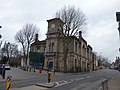 Bilston Town Hall - Church Street and Lichfield Street, Bilston (38775951175).jpg 4 608 × 3 456 ; 6,1 Mio
-
 Bilston Town Hall - Church Street and Lichfield Street, Bilston (39642419872).jpg 4 608 × 3 456 ; 6,45 Mio
-
 Bilston Tree - geograph.org.uk - 1638463.jpg 480 × 640 ; 65 kio
-
 Bilston Urban Village - geograph.org.uk - 482369.jpg 640 × 480 ; 266 kio
-
 Bilston Wasteland - geograph.org.uk - 1018972.jpg 640 × 480 ; 80 kio
-
 Bilston Wasteland - geograph.org.uk - 1021585.jpg 640 × 480 ; 124 kio
-
 BilstonGardenSeat.JPG 2 679 × 2 282 ; 1,71 Mio
-
 BilstonQS.jpg 640 × 480 ; 100 kio
-
 Borough Arms - geograph.org.uk - 803678.jpg 640 × 480 ; 59 kio
-
 Brownfield site - geograph.org.uk - 268387.jpg 600 × 450 ; 270 kio
-
 Cemetery View - geograph.org.uk - 1806472.jpg 800 × 600 ; 163 kio
-
 Diamond 20163 SN68 AJM at Bilston on 23.jpg 3 828 × 2 552 ; 6,51 Mio
-
 Disused Railway Footbridge - geograph.org.uk - 1009698.jpg 640 × 480 ; 94 kio
-
 Disused Railway Path - geograph.org.uk - 1009693.jpg 640 × 480 ; 101 kio
-
 Drill Hall - Coat of Arms (geograph 3839845).jpg 1 600 × 1 200 ; 363 kio
-
 East flank of Bilston Castle, or Hill.jpg 640 × 480 ; 146 kio
-
 Finntroll live at Bilston, Wolverhampton (04.10.2013).jpg 1 080 × 810 ; 263 kio
-
 Florence Avenue Bend - geograph.org.uk - 3210573.jpg 800 × 599 ; 65 kio
-
 Former Drill Hall - Mount Pleasant (geograph 3839839).jpg 1 600 × 1 200 ; 438 kio
-
 Former Drill Hall, Mount Pleasant, Bilston (geograph 2813126).jpg 1 280 × 1 009 ; 243 kio
-
 Gibbet Lane Bridge, Bilston.jpg 480 × 640 ; 71 kio
-
 God's Acre - geograph.org.uk - 997148.jpg 640 × 480 ; 113 kio
-
 Hall Green Cemetery - geograph.org.uk - 1188906.jpg 640 × 480 ; 79 kio
-
 Haven Hotel - geograph.org.uk - 990150.jpg 480 × 640 ; 74 kio
-
 Herbert Beach. JP. 1874-1953.jpg 500 × 494 ; 86 kio
-
 High Street Gate - geograph.org.uk - 1009758.jpg 640 × 480 ; 54 kio
-
 Homer's Fold - geograph.org.uk - 1009754.jpg 640 × 480 ; 83 kio
-
 Horse and Rider by Tessa Pullan.jpg 800 × 600 ; 84 kio
-
 Ian Parker at the Robin 2 (4194403657).jpg 1 358 × 638 ; 446 kio
-
 Island Garden - geograph.org.uk - 1018947.jpg 480 × 640 ; 100 kio
-
 Joe Gilbert saving penalty Bilston Town.png 576 × 426 ; 540 kio
-
 John Freeman - geograph.org.uk - 1477949.jpg 640 × 480 ; 74 kio
-
 Kingdom Hall Bilston - geograph.org.uk - 842854.jpg 640 × 480 ; 96 kio
-
 Ladymoor Pool - geograph.org.uk - 369755.jpg 640 × 480 ; 117 kio
-
 Land for the Urban Village - geograph.org.uk - 1021579.jpg 640 × 480 ; 97 kio
-
 Lewis Street View - geograph.org.uk - 1402509.jpg 640 × 480 ; 149 kio
-
 Livingstone Road Bridge - geograph.org.uk - 1008875.jpg 640 × 480 ; 120 kio
-
 Map of Bilston. Wellcome L0009563.jpg 1 830 × 1 104 ; 476 kio
-
 Market Butcher - geograph.org.uk - 1804268.jpg 600 × 800 ; 108 kio
-
 Market View - geograph.org.uk - 1806489.jpg 600 × 800 ; 144 kio
-
 Metro Bridge - geograph.org.uk - 1564580.jpg 640 × 480 ; 59 kio
-
 Metro View - geograph.org.uk - 1564596.jpg 640 × 480 ; 61 kio
-
 New houses by a pool on the Lunt - geograph.org.uk - 245961.jpg 640 × 329 ; 202 kio
-
 Old Railway Line Path - geograph.org.uk - 930086.jpg 480 × 640 ; 128 kio
-
 Park Alley - geograph.org.uk - 1007428.jpg 640 × 480 ; 107 kio
-
 Pen-Y-Cog bus on the A701 at Bilston, 14 February 2013.jpg 800 × 573 ; 194 kio
-
 Peter Green (4193246273).jpg 1 292 × 1 672 ; 1,21 Mio
-
 Peter Green 2 (4193246701).jpg 1 404 × 1 472 ; 706 kio
-
 Peter Green 3 (4193247407).jpg 2 280 × 1 704 ; 1,34 Mio
-
 Peter Green 4 (4194007128).jpg 3 432 × 2 280 ; 2,2 Mio
-
 Peter Green and Friends (4194909790).jpg 2 769 × 1 227 ; 1,14 Mio
-
 Play area at The Lunt - geograph.org.uk - 1469817.jpg 640 × 480 ; 113 kio
-
 Playing Field Hill - geograph.org.uk - 1495909.jpg 640 × 480 ; 91 kio
-
 Proud's Lane Nursery - geograph.org.uk - 988336.jpg 640 × 480 ; 78 kio
-
 Proud's lane Playing Fields - geograph.org.uk - 988284.jpg 640 × 480 ; 84 kio
-
 Queen Street Stadium, Bilston, May 2013.jpg 564 × 423 ; 143 kio
-
 Rathbone Close - geograph.org.uk - 1007418.jpg 640 × 480 ; 112 kio
-
 Rough Grazing on the Lunt - geograph.org.uk - 1086697.jpg 640 × 479 ; 256 kio
-
 School Flats Gate - geograph.org.uk - 1512539.jpg 640 × 480 ; 76 kio
-
 School Path - geograph.org.uk - 1021597.jpg 640 × 480 ; 97 kio
-
 Seven Stars Bilston.jpg 471 × 628 ; 63 kio
-
 Seven Stars circa 1934.png 520 × 326 ; 165 kio
-
 Seven Stars Inn 1932.jpg 500 × 422 ; 89 kio
-
 Short Street - geograph.org.uk - 1564552.jpg 640 × 480 ; 88 kio
-
 Skálmöld live in Bilston, Wolverhampton (04.10.2013).jpg 1 080 × 810 ; 178 kio
-
 Snowy Etheridge Road - geograph.org.uk - 1652641.jpg 640 × 480 ; 47 kio
-
 Snowy Forecourt - geograph.org.uk - 1652632.jpg 640 × 480 ; 90 kio
-
 Springvale Bowls Club - geograph.org.uk - 1009013.jpg 640 × 480 ; 99 kio
-
 Springvale Sports Field - geograph.org.uk - 1009026.jpg 640 × 480 ; 124 kio
-
 St Clement's Court - geograph.org.uk - 988376.jpg 640 × 480 ; 94 kio
-
 Steel bar rolling machinery - geograph.org.uk - 589195.jpg 640 × 480 ; 368 kio
-
 Stowlawn Terminus - geograph.org.uk - 2121281.jpg 800 × 600 ; 110 kio
-
 Tame Street, Bilston - geograph.org.uk - 1608557.jpg 640 × 480 ; 60 kio
-
 The Greyhound and Punchbowl 5 10 2023.jpg 471 × 628 ; 52 kio
-

-
 The Trumpet Bilston.jpg 1 500 × 2 000 ; 1,43 Mio
-
 Tommy Burton.jpg 728 × 739 ; 73 kio
-
 Town Centre, Bilston - geograph.org.uk - 1017490.jpg 640 × 480 ; 88 kio
-
 Travel Express PN07 KRZ.jpg 3 588 × 2 392 ; 5,94 Mio
-
 Týr live in Bilston, Wolverhampton (04.10.2013).jpg 1 080 × 810 ; 235 kio
-
 Villiers Avenue - geograph.org.uk - 988348.jpg 640 × 480 ; 103 kio
-
 Waiting for Bilston Urban Village - geograph.org.uk - 1021570.jpg 640 × 480 ; 62 kio
-
 Waiting for the Urban Village - geograph.org.uk - 996887.jpg 640 × 480 ; 66 kio
-
 West flank of Bilston Castle, or Hill.png 1 008 × 747 ; 1,01 Mio
-
 Wilkinson Primary School Signage.jpg 4 640 × 2 610 ; 2,88 Mio
-
 Wolverhampton Civic Housing - geograph.org.uk - 1753596.jpg 2 816 × 1 880 ; 2,42 Mio
-
 Woodcross viewed from Beacon Hill.jpg 1 460 × 1 095 ; 517 kio
-
 Alice Walk - geograph.org.uk - 1009678.jpg 640 × 480 ; 109 kio
-
 Arthur Street Bridge - geograph.org.uk - 990090.jpg 640 × 480 ; 58 kio
-
 Autumn colour beside the footpath - geograph.org.uk - 589290.jpg 640 × 480 ; 281 kio
-
 Beldray Passage - geograph.org.uk - 1401023.jpg 640 × 480 ; 64 kio
-
 Bilston Ambulance Station - geograph.org.uk - 803669.jpg 640 × 480 ; 87 kio
-
 Bilston Conservative Club - geograph.org.uk - 1494565.jpg 640 × 480 ; 124 kio
-
 Bilston Town FC - geograph.org.uk - 438090.jpg 600 × 450 ; 184 kio
-
 Bilston Wasteland - geograph.org.uk - 988231.jpg 640 × 480 ; 102 kio
-
 Bilston's Big Top 2009 - geograph.org.uk - 1478096.jpg 640 × 480 ; 135 kio
-
 Bingo Lawns - geograph.org.uk - 1009089.jpg 640 × 480 ; 107 kio
-
 Birchdale - geograph.org.uk - 1423420.jpg 640 × 480 ; 66 kio
-
 Bradley Arm Canal - geograph.org.uk - 1420538.jpg 640 × 426 ; 269 kio
-
 Bradley Path - geograph.org.uk - 675263.jpg 640 × 480 ; 132 kio
-
 Broad Street Bridge - geograph.org.uk - 996737.jpg 640 × 480 ; 96 kio
-
 Canal Side Living - geograph.org.uk - 675114.jpg 640 × 480 ; 100 kio
-
 Herberts Park Road Bridge - geograph.org.uk - 589822.jpg 640 × 480 ; 108 kio
-
 Moseley Park School - geograph.org.uk - 387759.jpg 640 × 480 ; 160 kio
-
 November Morning - geograph.org.uk - 399351.jpg 480 × 640 ; 94 kio
-
 Pool in open space next to Moseley Road - geograph.org.uk - 246005.jpg 640 × 480 ; 256 kio
-
 Porketts Bridge - geograph.org.uk - 412392.jpg 640 × 480 ; 130 kio
-
 The Grapes - geograph.org.uk - 705936.jpg 640 × 480 ; 74 kio
-
 The Grapes Pool - geograph.org.uk - 705944.jpg 640 × 480 ; 82 kio
-
 The Happy Wanderer - geograph.org.uk - 705949.jpg 640 × 480 ; 55 kio

.jpg)

.jpg)


.jpg)


.jpg)
.jpg)


.jpg)

.jpg)

.jpg)
.jpg)


.jpg)


.jpg)
.jpg)
.jpg)
.jpg)
.jpg)


.jpg)


.jpg)


