Category:Canadian River
둘러보기로 이동
검색으로 이동
river in the United States  řeka v Calvinu v Oklahomě  | |||||
| 미디어 올리기 | |||||
| 다음 종류에 속함 | |||||
|---|---|---|---|---|---|
| 위치 | |||||
| 길이 |
| ||||
| 수원지 | |||||
| 물길이 끝나는 곳 | |||||
| Drainage basin |
| ||||
| 여기로 흐르는 지류들 |
| ||||
 | |||||
English: Media related to the Canadian River, a river in the United States.
하위 분류
다음은 이 분류에 속하는 하위 분류 5개 가운데 5개입니다.
C
- Canadian River Wagon Bridge (9 F)
- Conchas Lake (New Mexico) (5 F)
L
- Lake Meredith (6 F)
W
- Wanette-Byars Bridge (4 F)
"Canadian River" 분류에 속하는 미디어
다음은 이 분류에 속하는 파일 34개 가운데 34개입니다.
-
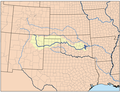 Canadianrivermap.png 500 × 385; 204 KB
-

-
 Alfl 3771.jpg 2,957 × 1,952; 1.48 MB
-
 Alfl canadian river at alibates 20060726164938.jpg 1,672 × 1,575; 405 KB
-
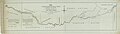 Altantic Pacific Railroad, general survey of the Ft Smith Branch - NARA - 102256236.jpg 21,088 × 5,920; 7.98 MB
-
 Canadian River basin map.png 1,200 × 759; 1.45 MB
-
 Canadian River Bridgeport Oklahoma.jpg 500 × 375; 73 KB
-
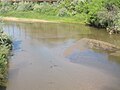
 Canadian River Calvin Oklahoma.jpg 500 × 337; 51 KB
-
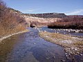
 Canadian River Fritch.jpg 355 × 266; 25 KB
-
 Canadian River in Canadian TX IMG 6056.JPG 4,000 × 3,000; 2.94 MB
-
 Canadian River near Mills Orchard Canyon ranch house.jpg 1,515 × 1,016; 1.61 MB
-
 Canadian River Railroad Bridge Logan New Mexico 2010.jpg 2,816 × 2,061; 1.74 MB
-
 Canadian River.jpg 3,072 × 2,304; 1.42 MB
-
 Canadianriver lg (22978606751).jpg 768 × 576; 98 KB
-
 Canadiian River Canyon MarkerJPG.jpg 1,778 × 1,185; 1,009 KB
-
 Fritch Fortress Boat Ramp.jpg 308 × 231; 21 KB
-
 Lake Meredith 2.jpg 1,600 × 1,200; 924 KB
-
 Lake Meredith Aerial 1.jpg 3,648 × 2,736; 3.27 MB
-
 Lake Meredith Aerial 2.jpg 3,072 × 2,304; 1.17 MB
-
 Lake Meredith NRA Fish Fry Tournament.jpg 1,152 × 864; 177 KB
-
 Lake Meredith Picnic Area.jpg 2,560 × 1,920; 2.21 MB
-
 Lamr FritchView0-0-0.jpg 256 × 192; 10 KB
-
 Lamr Sanfrd01.jpg 350 × 235; 19 KB
-
 Mills Canyon orchard area along Canadian River in Harding Co. New Mexico.jpg 2,575 × 1,721; 5.67 MB
-
 Mollhausen - Canadian River Near Camp 38.jpg 2,742 × 1,960; 984 KB
-
 NM Hwy 120 in the Canadian River Canyon.JPG 3,456 × 2,304; 2.44 MB
-
 Oklahoma - Norman - NARA - 68147210.jpg 6,882 × 5,374; 17.05 MB
-
 Oklahoma - Purcell through Witchita National Forest - NARA - 68147236.jpg 6,882 × 5,374; 17.09 MB
-

-

-

-
 Rise in Canadian River Sept. 8-'09. (12211119583).jpg 3,000 × 1,893; 3.22 MB
-
 Vincent Colyer - Scene on the Canadian River - Google Art Project.jpg 2,400 × 1,433; 919 KB
-

.jpg)


.jpg)


_(14574196169).jpg)
_(14737852556).jpg)
_(14757789211).jpg)
.jpg)

분류:
- Rivers of Colorado
- Rivers of New Mexico
- Rivers of Texas
- Rivers of Oklahoma
- Rivers of the Western United States
- Rivers of the United States by name
- Locations along Interstate 35 in Oklahoma
- Locations along Interstate 40 in Oklahoma
- Locations along Interstate 44 in Oklahoma
- Locations along Interstate 25 in New Mexico
- Locations along U.S. Route 69 in Oklahoma
- Locations along U.S. Route 77 in Oklahoma
- Locations along U.S. Route 81 in Oklahoma
- Locations along U.S. Route 177 in Oklahoma
- Locations along U.S. Route 183 in Oklahoma
- Locations along U.S. Route 270 in Oklahoma
- Locations along U.S. Route 281 in Oklahoma
- Locations along U.S. Route 283 in Oklahoma
- Locations along U.S. Route 377 in Oklahoma
- Locations along U.S. Route 54 in New Mexico
- Locations along U.S. Route 64 in New Mexico
- Locations along U.S. Route 85 in New Mexico
- Locations along U.S. Route 412 in New Mexico
- Locations along U.S. Route 60 in Texas
- Locations along U.S. Route 287 in Texas
- Locations along U.S. Route 385 in Texas
- Locations along Oklahoma State Highway 2
- Locations along Oklahoma State Highway 4
- Locations along Oklahoma State Highway 5
- Locations along Oklahoma State Highway 33
- Locations along Oklahoma State Highway 34
- Locations along Oklahoma State Highway 48
- Locations along New Mexico State Road 104
- Locations along New Mexico State Road 120
- Locations along New Mexico State Road 410
- Locations along New Mexico State Road 419
- Locations along New Mexico State Road 555
- Locations along Texas State Highway 136