Category:Church of the Ascension of Christ (Surmino)
Jump to navigation
Jump to search
| Object location | | View all coordinates using: OpenStreetMap |
|---|
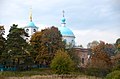
Русский: Храм Вознесения Господня в селе Сурмино (Московская область, Дмитровский район).
church building, architectural landmark in Russua  | |||||
| Upload media | |||||
| Instance of | |||||
|---|---|---|---|---|---|
| Location | Q16703477, Kostinskoe Settlement, Dmitrovsky District, Moscow Oblast, Russia | ||||
| Heritage designation | |||||
| Inception |
| ||||
 | |||||
Media in category "Church of the Ascension of Christ (Surmino)"
The following 10 files are in this category, out of 10 total.
-
 Church of the Ascension of Christ (Surmino) 04.jpg 2,704 × 3,018; 5.58 MB
-
 Church of the Ascension of Christ (Surmino) 06.jpg 4,260 × 2,912; 9.19 MB
-
 Church of the Ascension of Christ (Surmino) 08.jpg 1,652 × 3,492; 3.22 MB
-
 Church of the Ascension of Christ (Surmino) 10.jpg 2,800 × 3,800; 5.75 MB
-
 Church of the Ascension of Christ (Surmino) 12.jpg 2,200 × 3,800; 3.91 MB
-
 Church of the Ascension of Christ (Surmino) 14.jpg 2,800 × 3,800; 3.89 MB
-
 Вознесенская церковь, с.Сурмино, Дмитровский район, Московская область..jpg 2,136 × 1,424; 871 KB
-
 Вознесенская церковь, с.Сурмино.jpg 2,032 × 1,336; 831 KB
-
 Сурмино01.jpg 3,029 × 3,699; 7.08 MB
-
 Сурмино02.jpg 2,838 × 4,191; 7.36 MB
_04.jpg)
_06.jpg)
_08.jpg)
_10.jpg)
_12.jpg)
_14.jpg)


