Category:Commandeurstraat 12, West-Terschelling
Jump to navigation
Jump to search
| Object location | | View all coordinates using: OpenStreetMap |
|---|
 | |||||
| Upload media | |||||
| Instance of |
| ||||
|---|---|---|---|---|---|
| Location | West-Terschelling, Terschelling, Friesland, Netherlands | ||||
| Heritage designation |
| ||||
 | |||||
|
This is a category about rijksmonument number 35045
|
| Address |
|
Media in category "Commandeurstraat 12, West-Terschelling"
The following 2 files are in this category, out of 2 total.
-
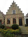 Commandeurstraat 12 in West-Terschelling -01.jpg 3,216 × 4,288; 3 MB
-
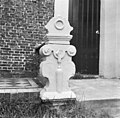 Stoeppaal - West-Terschelling - 20254793 - RCE.jpg 1,200 × 1,178; 348 KB
