Category:Doggerland
Salti al navigilo
Salti al serĉilo
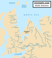
land mass submerged now beneath the southern North Sea that connected Britain to continental Europe  Mapa que mostra l'extensió hipotètica de Doggerland (cap al 8.000 a.C.), que feia de pont terrestre entre Gran Bretanya i l'Europa continental. | |||||
| Alŝuti plurmedion | |||||
| Estas | |||||
|---|---|---|---|---|---|
| Nomita laŭ | |||||
| Loko | Norda Maro | ||||
| Malkovrinto aŭ inventinto |
| ||||
| Areo |
| ||||
 | |||||
Dosieroj en kategorio “Doggerland”
La jenaj 14 dosieroj estas en ĉi tiu kategorio, el 14 entute.
-
 200805231215 Wollhaarmammut Millie Schädel.jpeg 3 120 × 1 954; 552 KB
-
 Clement Reid - Map Doggerbank.jpg 1 020 × 1 291; 464 KB
-
 Doggerland 10,000 BP.jpg 620 × 740; 79 KB
-
 Doggerland-af.svg 545 × 600; 144 KB
-
 Doggerland-cy.svg 545 × 600; 122 KB
-
 Doggerland.png 1 583 × 1 686; 3,83 MB
-
 Doggerland.svg 545 × 600; 165 KB
-
 Doggerland3er en.png 2 166 × 1 212; 1,19 MB
-
 Doggerland3er.png 2 166 × 1 212; 1,5 MB
-
 Early Holocene landscape features mapped by the North Sea Palaeolandscapes Project.png 1 879 × 2 477; 2,88 MB
-
 Map Doggerbank 1867.jpg 910 × 1 246; 215 KB
-
 Nordsjølandet.JPG 385 × 443; 73 KB
-
 Sjøkart over Nordsjøen og Kattegat, fra 1796.png 3 262 × 3 830; 25,79 MB
-
 Submerged forests (1913), 054.png 1 392 × 1 752; 1,81 MB


,_054.png)