Category:Dådrans kapell
Jump to navigation
Jump to search
| Object location | | View all coordinates using: OpenStreetMap |
|---|
church building in Rättvik Municipality, Sweden  | |||||
| Upload media | |||||
| Instance of | |||||
|---|---|---|---|---|---|
| Location | Rättvik Municipality, Dalarna County, Sweden | ||||
| Diocese | |||||
| Occupant |
| ||||
 | |||||
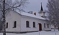
Svenska: Dådrans kapell tillhör Rättviks församling, Falu-Nedansiljans kontrakt, Västerås stift / Diocese of Västerås.
|
This is a category about an ecclesiastical monument in Sweden, number 21300000003922 (sub-number: 21400000442380) in the RAÄ buildings database.
|
Media in category "Dådrans kapell"
The following 5 files are in this category, out of 5 total.
-
 Dådrans kapell - kmb.16000200007953.jpg 427 × 600; 68 KB
-
 Dådranskapell21500001338625.jpg 1,112 × 793; 347 KB
-
 Dådranskapell21500001338626.jpg 1,233 × 733; 219 KB
-
 Dådranskapell21500001338627.jpg 815 × 629; 89 KB
-
 Dådranskapell21500001338628.jpg 1,145 × 635; 102 KB


