Category:Earthquakes in Japan
Sari la navigare
Sari la căutare
Țări în Asia: Afganistan · Arabia Saudită · Armenia‡ · Azerbaidjan‡ · Bangladesh · Cipru‡ · Coreea de Nord · Coreea de Sud · Egipt‡ · Filipine · Georgia‡ · India · Indonezia‡ · Irak · Iran · Israel · Japonia · Kârgâzstan · Laos · Malaysia · Mongolia · Myanmar · Nepal · Pakistan · Republica Populară Chineză · Rusia‡ · Siria · Tadjikistan · Thailanda · Timorul de Est · Turcia‡ · Uzbekistan · Yemen
Recunoaștere limitată: Taiwan
‡: partly located in Asia
Recunoaștere limitată: Taiwan
‡: partly located in Asia
日本語: 日本の地震に関するカテゴリ
 | |||||
| Încarcă multimedia | |||||
| Subclasă a | |||||
|---|---|---|---|---|---|
| Locul actual |
| ||||
| |||||
Subcategorii
Această categorie conține următoarele 12 subcategorii, dintr-un total de 12.
Fișiere media din categoria „Earthquakes in Japan”
Următoarele 37 fișiere se află în această categorie, dintr-un total de 37.
-
 20240210-P1038605.jpg 1.600x1.200; 747 KB
-
 20240210-P1038610.jpg 1.600x1.200; 588 KB
-
 20240210-P1038613.jpg 1.600x1.200; 631 KB
-
 Block Diagram showcasing earthquake hypocenter.jpg 3.371x1.956; 1,32 MB
-
 Booklet of where fires started during a massive earthquake in Edo (13719911853).jpg 2.500x1.834; 1,83 MB
-
 The contents of the publications of the Imperial Earthquake Investigation Committee (IA contentsofpublic00shin).pdf 983 × 1.489, 62 de pagini; 3,81 MB
-
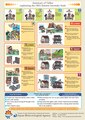
 Earthquake Kit in Japan 2008.jpg 2.020x2.020; 2,3 MB
-
 Earthquake, Five Hundred Arhats, Scrolls 81 & 82.jpg 584x592; 116 KB
-
 Earthquake-proof glass in Sahara-glass-park.jpg 1.280x960; 252 KB
-
 Earthquakes of M7.6 or above in Japan.png 1.428x725; 192 KB
-
 ECDM 20210216 Japan EQ.pdf 1.625x1.125; 619 KB
-
 Evacuation route sign.jpg 1.280x960; 193 KB
-
 Exit sign.jpg 601x400; 190 KB
-
 Explanation of the earthquake (14942869109).jpg 1.466x2.000; 1,33 MB
-
 An Investigation of the Miyagi-ken-oki, Japan, earthquake of June 12, 1978 (IA investigationofm592elli).pdf 1.104 × 1.487, 236 de pagini; 17,91 MB
-
 Japan Recorded Earthquakes.png 162x364; 6 KB
-

-

-
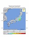
 JMA Tsunami Warnings 1 January 2024 ja.png 878x988; 257 KB
-
 Kanto earthquakes.gif 681x541; 157 KB
-

-

-

-
 M≥6.0 (1960-2022) Earthquakes in the Ryukyu Arc.png 785x690; 2,07 MB
-
 NK-TZ.jpg 868x824; 308 KB
-
 Sanriku-Erdbeben.jpg 796x858; 161 KB
-
 Shizuoka bank Hamamatsu Seismic Isolation Building.jpg 640x480; 98 KB
-
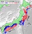 Slow and fast earthquakes in the Nankai Trough and Japan Trench.jpg 4.418x4.774; 1,46 MB
-
 Summary of Tables explaining the JMA Seismic Intensity Scale.pdf 1.239x1.752; 803 KB
-
-
 USGS Intensity Map March 25 2007 Nanao Earthquake M 6.7.pdf 1.231x1.547; 2,99 MB
-
 USGS Intensity Map May 5 2023 Ishikawa Earthquake M 6.2.pdf 1.231x1.562; 2,67 MB
-
 Wikinews Japan earthquake.png 2.968x345; 171 KB
-
 地震防災対策強化地域.png 593x406; 73 KB
-
 日本の地震予知体制.gif 687x416; 30 KB
-
 観測強化地域・特定観測地域.gif 703x360; 18 KB
-
 高床 免震 (43041871111).jpg 4.000x2.250; 1,11 MB


.jpg)


.jpg)


_Earthquakes_in_the_Ryukyu_Arc.png)


.jpg)