Category:Friesenstraße 49 (Köln)
Jump to navigation
Jump to search
| Object location | | View all coordinates using: OpenStreetMap |
|---|
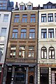
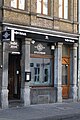
| This category shows a heritage building in Germany, located in the North Rhine-Westphalian city Köln (no. 3523). |
Media in category "Friesenstraße 49 (Köln)"
The following 6 files are in this category, out of 6 total.
-
 WikiCon 2014 Fotoexkursion (063).JPG 3,264 × 4,912; 4.66 MB
-
 WikiCon 2014 Fotoexkursion (064).JPG 3,264 × 4,912; 4.54 MB
-
 WikiCon 2014 Fotoexkursion (065).JPG 3,264 × 4,912; 5.1 MB
-
 WikiCon 2014 Fotoexkursion (066).JPG 3,264 × 4,912; 4.85 MB
-
 WikiCon 2014 Fotoexkursion (069).JPG 3,264 × 4,912; 4.1 MB
-
 WikiCon 2014 Fotoexkursion (070).JPG 3,264 × 4,912; 4.26 MB
.JPG)
.JPG)
.JPG)
.JPG)
.JPG)
.JPG)