Category:Friesenstraße 59 (Köln)
Jump to navigation
Jump to search
| Object location | | View all coordinates using: OpenStreetMap |
|---|
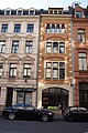
| This category shows a heritage building in Germany, located in the North Rhine-Westphalian city Köln (no. 4708). |
Media in category "Friesenstraße 59 (Köln)"
The following 9 files are in this category, out of 9 total.
-
 WikiCon 2014 Fotoexkursion (032).JPG 3,264 × 4,912; 4.04 MB
-
 WikiCon 2014 Fotoexkursion (033).JPG 3,264 × 4,912; 4.58 MB
-
 WikiCon 2014 Fotoexkursion (034).JPG 4,912 × 3,264; 3.9 MB
-
 WikiCon 2014 Fotoexkursion (035).JPG 4,912 × 3,264; 4.29 MB
-
 WikiCon 2014 Fotoexkursion (036).JPG 3,264 × 4,912; 3.78 MB
-
 WikiCon 2014 Fotoexkursion (037).JPG 3,264 × 4,912; 3.49 MB
-
 WikiCon 2014 Fotoexkursion (038).JPG 4,912 × 3,264; 3.16 MB
-
 WikiCon 2014 Fotoexkursion (040).JPG 4,912 × 3,264; 4.17 MB
-
 WikiCon 2014 Fotoexkursion (041).JPG 4,912 × 3,264; 4.28 MB
.JPG)
.JPG)
.JPG)
.JPG)
.JPG)
.JPG)
.JPG)
.JPG)
.JPG)