Category:Geographic information systems
नेविगेशन पर जाएँ
खोज पर जाएँ
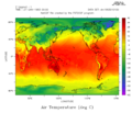
spatial data information systems  Map by John Snow in 1854; cholera cases highlighted in black  | |||||
| मीडिया अपलोड करें | |||||
| Pronunciation audio | |||||
|---|---|---|---|---|---|
| जिसका उदाहरण है |
| ||||
| जिसका उपवर्ग है | |||||
| उपयोग |
| ||||
| निर्माण की तिथि |
| ||||
| इससे अलग | |||||
| |||||
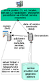
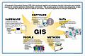
A geographic information system (GIS), also known as a geographical information system, is an information system for capturing, storing, analyzing, managing and presenting data which is spatially referenced (linked to location).
उपश्रेणियाँ
इस श्रेणी की कुल २४ में से २४ उपश्रेणियाँ निम्नलिखित हैं।
3
- 3D city models (27 F)
A
- Atlas okolja (3 F)
D
- DE-9IM (11 F)
G
- Geonames (11 F)
- GeoSUR (3 F)
- GIS promo image (1 F)
N
- NEXRAD network maps (6 F)
R
S
- Simple feature access (9 F)
W
- Web Map Tile Service (1 F)
"Geographic information systems" श्रेणी में मीडिया
इस श्रेणी की कुल २९२ में से २०० चित्र निम्नलिखित हैं।
(पिछला पृष्ठ) (अगला पृष्ठ)-
 2023-05-13 Augusta Raurica TOT 058.jpg ६,००० × ४,०००; ६.२९ MB
-
 Adlinterface.png ९०० × ६३३; ११३ KB
-
 Alagoas Geográfico.png ९४४ × ४६५; २३७ KB
-
 Algoritmo Radial. Sumatoria radial de ángulos.png ३६२ × २८७; १५ KB
-
 AlkadiPicture.jpg ७७३ × १,०२४; ३९ KB
-
 All findspots mapped from 2003 onwards.jpg ६३२ × ६२६; ३५० KB
-
 All findspots mapped up until 2003.jpg ६२२ × ६२०; १४२ KB
-
 ALPS Globe.jpg १,००० × ९४२; ८०३ KB
-
 An Geomatist.jpg ३,६४८ × २,७३६; ३.२२ MB
-
 Arizona-Roads-GIS.png १०,००० × १०,०००; २९.३१ MB
-
 ASCII grid example.svg २१० × ३३०; ३ KB
-
 Austin Texas LiDAR Point Cloud (Highway 183).png १,९२० × ७८०; २.९५ MB
-
 AxiomaGIS.png ६५२ × ३६८; ७५६ KB
-
 Bordeaux–Paris route overlay.svg २२० × २११; ९९५ B
-
 CAA-PRIMARY-LOGO-with-SUBTITLE-RGB website.png ३०० × १४८; २३ KB
-
 California -- Roads using GIS data.png १०,००० × १०,०००; २५.९५ MB
-
 CartographyNoLongerKing.svg १,०५२ × ७४४; ५८ KB
-
 Check-fil-A and Baptist Church Heat Map.png ३,५०७ × २,४८०; १.२८ MB
-
 City of Minneapolis Street Map (16462765573).jpg ५,७६० × ३,८४०; १०.२३ MB
-
 Copernicus 1891-2023.jpg ४,५६४ × ३,२१२; ५.४९ MB
-
 Costcorridor.png ९८९ × १,१६५; ८५ KB
-
 Costpath Flowchart.png ९८९ × २,०६५; १३३ KB
-
 Coverage encoding variants.png ८९५ × २९८; २७ KB
-
 CreerTerrain.jpg १,९२० × १,१७०; २९४ KB
-
 Cybergis-roger.jpg २,०४८ × १,५३६; ५७० KB
-
 DatendimensionenImGIS.jpg १,३४६ × ३५०; ५८ KB
-
 DG GOGIS and Chairman GOSUPDA.jpg ३,९३६ × १,७२८; १.७२ MB
-
 DGGs-asOGC-topic21-fig1.png १,२०० × ४४९; २०१ KB
-
 Diagrama flujo GIS obra lineal.jpg १,५८७ × १,१२३; ११४ KB
-

-
 Digimap roam.png २५० × १४३; ७२ KB
-
 Digitizing errors.jpg २,३७० × २,११०; ८०४ KB
-
 Digitizing errors.svg २१० × ५२४; ९ KB
-
 DimensionesdelosdatosSIG.jpg १,३४६ × ३५०; ५६ KB
-
 Director General of GOGIS and Technical Team 01.jpg ३,९३६ × १,७२८; २ MB
-
 Director General of GOGIS and Technical Team 02.jpg ३,९३६ × १,७२८; १.८१ MB
-
 Director General of GOGIS and Technical Team 03.jpg ३,९३६ × १,७२८; १.८२ MB
-
 Director General of GOGIS and Technical Team 04.jpg ३,९३६ × १,७२८; २.०१ MB
-
 Director General of GOGIS and Technical Team 05.jpg ३,९३६ × १,७२८; २.१९ MB
-
 Director General of GOGIS and Technical Team 06.jpg ३,९३६ × १,७२८; २.२५ MB
-
 Director General of GOGIS and Technical Team 07.jpg ३,९३६ × १,७२८; २.२३ MB
-
 Director General of GOGIS and Technical Team 08.jpg ३,९३६ × १,७२८; २.१२ MB
-
 Director General of GOGIS and Technical Team 09.jpg ३,९३६ × १,७२८; २.२६ MB
-
 Director General of GOGIS and Technical Team 10.jpg ३,९३६ × १,७२८; २.१९ MB
-
 Director General of GOGIS and Technical Team 11.jpg ३,९३६ × १,७२८; २.०८ MB
-
 Director General of GOGIS and Technical Team 12.jpg ३,९३६ × १,७२८; १.९४ MB
-
 Director General of GOGIS and Technical Team 13.jpg ३,९३६ × १,७२८; २.२१ MB
-
 Director General of GOGIS and Technical Team 14.jpg ३,९३६ × १,७२८; २.३१ MB
-
 Director General of GOGIS and Technical Team 15.jpg ३,९३६ × १,७२८; २.०८ MB
-
 Director General of GOGIS and Technical Team 16.jpg ३,९३६ × १,७२८; २.०१ MB
-
 Director General of GOGIS and Technical Team 17.jpg ३,९३६ × १,७२८; २.४३ MB
-
 Director General of GOGIS and Technical Team 18.jpg ३,९३६ × १,७२८; २.१६ MB
-
 Director General of GOGIS and Technical Team 19.jpg ३,९३६ × १,७२८; १.६८ MB
-
 Director General of GOGIS and Technical Team 20.jpg ३,९३६ × १,७२८; २.६४ MB
-
 Director General of GOGIS and Technical Team 21.jpg ३,९३६ × १,७२८; २.१७ MB
-
 Donut polygonen en topologie voorbeelden.PNG ८३६ × ७५२; ५६ KB
-
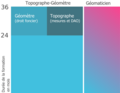 Durée et cursus Topographe-Géomètre et Géomaticien en Allemagne.png २,५६० × १,९७७; २९३ KB
-
 EditingField.jpg ७३० × ३८२; ५४ KB
-
 EFDAC-Map-Viewer-thumbnail.jpg २७४ × १७०; १८ KB
-
 Eine einfache Landkarte im Vektorformat.svg २५० × २००; ७ KB
-
 Erosiegevoeligheidskartering3.PNG १,३०० × ८६३; ३.३६ MB
-
 Esquema GIS convencional.png ७२३ × २६९; ५३ KB
-
 Esquema GIS nuevo.png ७२३ × २६९; ६५ KB
-
 Etapes du MNZI.jpg १,४७५ × १,३००; ६६३ KB
-
 Euripus SWBD demo.svg १,४३२ × १,६५५; १.७८ MB
-
 Exemple de transformation.jpg ३१७ × ४४६; १२ KB
-
 Ferret program.png ७६८ × ६६२; ५४ KB
-
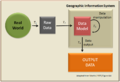 Fig 4.4.png ९३२ × ६४०; ६७ KB
-
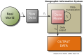 Fig 4.4.svg ८७८ × ५७५; २४ KB
-
 Fig soilmap types.pdf १,७५४ × १,२३९; ३८ KB
-
 Fig soilmap types.png २,१४७ × १,३८८; ५० KB
-
 Fish Movements USGS.JPG ६३७ × ६१७; ३६ KB
-
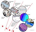
 FM Tree Raster Figure 1.jpeg ७८२ × ७५२; १९९ KB
-
 Gabor en omgeving voorbeeld classificatie puntobjecten legenda items.PNG १,२१५ × ५२९; ९४ KB
-
 GBHGIS meta architecture.gif ३१० × २१८; ९ KB
-
 Geabios3d.jpg २८० × २४२; १४ KB
-
 Geo visualisatie met een gis op drie wijzen.PNG १,१५७ × ३८९; ३५ KB
-
 Geo visualisatie met een gis op twee wijzen.PNG १,०६५ × ५१०; ३२ KB
-
 Geo-portaal-net-niet.PNG ३६१ × ६७१; २५ KB
-
 Geo-portaal-wel.PNG ४०६ × ६७२; ३५ KB
-
 Geoarcut Logo Gris.jpg ३८८ × २२८; २३ KB
-
 GeoBImarket GIS analytical platform. Analysis of geospatial data.png १,३६६ × ६८६; १.६२ MB
-
 Geographic Information System example.jpg ७२८ × ८३६; २४७ KB
-
 Geomajas screenshot.jpg १,९२० × १,०३८; ५६५ KB
-
 GeoPista.gif ९४६ × ६८७; २२० KB
-
 Geoprocessamento Epagri Ciram.JPG २,३०४ × ३,०७२; २.५८ MB
-
 Georefererenstap2.PNG ११६ × १५२; ३ KB
-
 Geoservices server with apps.png ६९४ × ५६९; ४४ KB
-
 Geothermische Standorte.gif १,००० × ६६५; १२४ KB
-
 GIP Detailansicht Wien, Kreuzung Schottenring-Börsegasse.png १,५०० × ९११; ७१५ KB
-
 GIS 2.jpg ७०२ × १,२०२; ६०५ KB
-
 Gis bestand definities.PNG ९४८ × ४०८; ३२ KB
-
 GIS de nodos.png ७२३ × २६९; ६६ KB
-
 GIS hierarchic model.png २,०४० × १,६००; १११ KB
-
 GIS Layers.png ८०० × ५३२; ५२७ KB
-
 GIS user.svg ८०७ × ६३५; १.०३ MB
-
 GIS-bewerkingen afh van projectie.png १,००० × २६३; ६०२ KB
-
 Gis-data-opslag.PNG ७७९ × ४६५; २६ KB
-
 Gis-data-opslag.png ७७५ × ४१०; २२ KB
-
 Gis-data-voorbeeld.PNG १,२५२ × ९१७; ४९ KB
-
 GIS-definities.PNG १,२११ × ४५८; ८५ KB
-
 Gis-reken-voorbeelden.PNG १,५३८ × ३९०; ५६ KB
-
 Gis2.jpg २७५ × १८३; ११ KB
-
 GISc lex.png ९६० × ७२०; ४१ KB
-
 Gislayers.jpg ९९७ × ६५७; ३०० KB
-
 GisLayers.png ९९७ × ६५७; १.३९ MB
-
 Gismodelvoobeeld.PNG १,०३३ × ७८१; ३०५ KB
-
 Gismodelvoorbeeldtotstandkoming.PNG १,०२७ × ९५६; ४३१ KB
-
 GISNetworkExample.svg ८६२ × २९५; ३८ KB
-
 Global OFG.png ७१४ × ५४७; २८८ KB
-
 GMT Example 01.jpg ९९५ × १,०४०; १५७ KB
-
 GMT Example 02.jpg १,१२२ × १,१५५; २०८ KB
-
 Goede visuele hiërarchie 3D model.PNG १,१२१ × ६३९; ३२ KB
-
 GOGIS Receives Staff of Ashaka 01.jpg ३,९३६ × १,७२८; २.०१ MB
-
 GOGIS Receives Staff of Ashaka 02.jpg ३,९३६ × १,७२८; १.५१ MB
-
 GOGIS Receives Staff of Ashaka 03.jpg ३,९३६ × १,७२८; १.९४ MB
-
 GOGIS Receives Staff of Ashaka 04.jpg ३,९३६ × १,७२८; १.९९ MB
-
 GOGIS Receives Staff of Ashaka 05.jpg ३,९३६ × १,७२८; २.०२ MB
-
 GOGIS Receives Staff of Ashaka 06.jpg ३,९३६ × १,७२८; १.८५ MB
-
 GOGIS Receives Staff of Ashaka 07.jpg ३,९३६ × १,७२८; १.५१ MB
-
 GOGIS Receives Staff of Ashaka 08.jpg ३,९३६ × १,७२८; १.६७ MB
-
 GOGIS Receives Staff of Ashaka 09.jpg ३,९३६ × १,७२८; १.५२ MB
-
 GOGIS Receives Staff of Ashaka 10.jpg ३,९३६ × १,७२८; १.८२ MB
-
 GOGIS Receives Staff of Ashaka 11.jpg ३,९३६ × १,७२८; १.८१ MB
-
 GOGIS Receives Staff of Ashaka 12.jpg ३,९३६ × १,७२८; १.६८ MB
-
 GOGIS Receives Staff of Ashaka 13.jpg ३,९३६ × १,७२८; १.४१ MB
-
 GOGIS Receives Staff of Ashaka 14.jpg ३,९३६ × १,७२८; १.४१ MB
-
 GOGIS Receives Staff of Ashaka 15.jpg ३,९३६ × १,७२८; १.५१ MB
-
 GOGIS Receives Staff of Ashaka 16.jpg ३,९३६ × १,७२८; १.५ MB
-
 GOGIS Receives Staff of Ashaka 17.jpg ३,९३६ × १,७२८; १.२३ MB
-
 GOGIS Receives Staff of Ashaka 18.jpg ३,९३६ × १,७२८; १.५१ MB
-
 GOGIS Receives Staff of Ashaka 19.jpg ३,९३६ × १,७२८; १.६७ MB
-
 GOGIS Receives Staff of Ashaka 20.jpg ३,९३६ × १,७२८; १.९ MB
-
 GOGIS Receives Staff of Ashaka 21.jpg ३,९३६ × १,७२८; १.८५ MB
-
 GOGIS Receives Staff of Ashaka 22.jpg ३,९३६ × १,७२८; १.६७ MB
-
 GOGIS Receives Staff of Ashaka 23.jpg ३,९३६ × १,७२८; २.०५ MB
-
 GOGIS Receives Staff of Ashaka 24.jpg ३,९३६ × १,७२८; १.८७ MB
-
 GOGIS Receives Staff of Ashaka 25.jpg ३,९३६ × १,७२८; २.५३ MB
-
 GOGIS Receives Staff of Ashaka 26.jpg ३,९३६ × १,७२८; २.३७ MB
-
 GOGIS Receives Staff of Ashaka 27.jpg ३,९३६ × १,७२८; १.८ MB
-
 GOGIS Receives Staff of Ashaka 28.jpg ३,९३६ × १,७२८; १.५५ MB
-
 GOGIS Receives Staff of Ashaka 29.jpg १,६२० × ७११; ८५३ KB
-
 GOGIS Receives Staff of Ashaka 31.jpg ३,९३६ × १,७२८; १.७७ MB
-
 GOGIS Receives Staff of Ashaka 32.jpg ३,९३६ × १,७२८; १.७१ MB
-
 GOGIS Receives Staff of Ashaka 33.jpg १,६२० × ७११; ९०१ KB
-
 GOGIS Receives Staff of Ashaka 34.jpg १,६२० × ७११; ८८३ KB
-
 GOGIS Receives Staff of Ashaka 35.jpg ३,९३६ × १,७२८; १.६ MB
-
 GOGIS Receives Staff of Ashaka 36.jpg ३,९३६ × १,७२८; २.१९ MB
-
 Grafische variabelen en hun toepassingemogelijkheden binnen de cartografie.PNG १,०८० × १,१९०; ८६ KB
-
 Grand-Lake-River.png २,००० × १,३५६; २११ KB
-
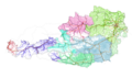 Graphenintegrations-Plattform GIP Österreich.png १,५९२ × ९४१; १.४२ MB
-
 Green Fee Logo.png ७३० × ७००; १६४ KB
-
 GroundTruth processModel01.png ५४८ × २२०; २३ KB
-
 Hellingklassenkaart voorbeeld.jpg ५०० × ९६४; १९२ KB
-
 Hetbelangvanbuitengrenzen voorbeeldfiguur.PNG ५९८ × १,१२१; ३३ KB
-
 Home Owners' Loan Corp. (HOLC) Neighborhood Redlining Grade in Houston, Texas.png २,३७१ × १,६७९; ४.०५ MB
-
 Horizontalschnitt.png १,००० × ६५३; ३६५ KB
-
 How PostGIS Topology is implemented.svg ६९० × ६३८; २९ KB
-
 Illinois-Roads-GIS.png ६,१९३ × १०,०००; १९.३८ MB
-
 Imago3D.jpg १,०८८ × ५५७; २७२ KB
-
 Informing biodiversity maps.png ९६६ × ६०८; ८९ KB
-
 InteroperableIntegrationOfSpatialData.svg ६९७ × ७६७; १७ KB
-
 JDTM ZK webportal small.gif ३२० × २१८; ४२७ KB
-
 JDTM ZK webportal.gif १,२६६ × ८६४; ५.९१ MB
-
 Kaart voorbeelden output formaten.PNG ७४४ × ८५२; १८६ KB
-
 Kahlenbergrutschung.png १,२९३ × ८७६; २.१४ MB
-
 Keymap SDK Mobile.PNG २८६ × ४८९; ९३ KB
-
 Labellen wat wel en wat niet te doen.PNG ६४५ × ८६४; ४८ KB
-
 LANDFIRE's Fire Regime Group Map.jpg ३२० × २०७; २३ KB
-
 Lineair Refereren input voorbeeld bestanden A50.PNG ८८४ × ५५२; ३७ KB
-
 Lineair Refereren output voorbeeld bestanden A50.PNG १,१२६ × ५६७; ३७ KB
-
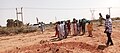
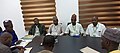
 Locals using Geographic Information System (18256648788).jpg १,५०० × १,१२५; २९६ KB
-
 Logische Datenstruktur GR.png ८८९ × ८३७; २५ KB
-
 Logo CAA 2023.svg २६४ × ८२; ४६ KB
-
 Logo Rt.jpg १५२ × ६०; ३ KB
-
 Luna en proyección ortográfica.jpg ८,५८४ × ४,९२४; १२.४९ MB
-
 Map of water sources in Western United States.svg १,०५२ × ७४४; २.०४ MB
-
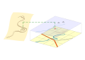 Map regression - transcription.svg १,०५२ × ७४४; ७१ KB
-
 Mapa de isohipsas 10 m.jpg ५,९०६ × ५,९०६; १८.५९ MB
-
 MapAlgebra.png २,४०६ × २,०५१; १८८ KB
-
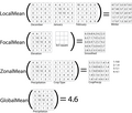
 Maup csr.png ५९५ × ६५९; १४१ KB
-
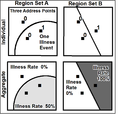 Maup rate numbers.png ९७० × ९२५; ५० KB
-
 Miami OSM Bulk Building Import Potential.png १,८०४ × १,८२२; ३.२९ MB
-
 Mm gaudi curt gisrs.gif ३९२ × ८०; १६ KB
-
 Moiré kandidaat kaart.PNG ६६३ × ६०९; २१ KB
-
 Neighborhood graph.png ६६५ × ६६०; १६ KB
-
 NetworkType.png ४३५ × २८९; ६२ KB
-
 New Jersey-Roads-GIS.png ५,८८८ × १०,०००; १९.३ MB
-
 Objectgericht gekoppeld stap5.PNG ११६ × १५२; २ KB
-
 Objectgericht getekend stap4.PNG ११६ × १५२; १ KB
-
 Objectgericht tekenen.PNG १,२४८ × ८५५; ३२ KB
-
 OGC WCS Suite, Logical Suite.png १,१०९ × ८६१; ५५ KB
-
 OGC WCS, trim and slice operations.png ४९९ × ४८९; ८ KB
-
 Oklahoma gis.jpg ५३० × ४१०; ४७ KB
-
 OpenJUMP-GUI.png १,०१८ × ७३५; ८६९ KB
-
 OpenStreetMap routing service.png ४८४ × ४९०; ९३ KB
-
 Opilux-1.png ९४२ × ६७२; १.५५ MB
-
 Opilux-2.png ४६५ × ३२९; १५६ KB
-
 OSM data in OpenJUMP.png १,२८० × ९९८; १.२८ MB
-
 Overlap.png २८५ × ११७; २ KB


.jpg)


..jpg)


_Neighborhood_Redlining_Grade_in_Houston,_Texas.png)


.jpg)


.png)