Category:Geography of China
Gezinti kısmına atla
Arama kısmına atla
geographical aspect of China   | |||||
| Medya yükle | |||||
| Nedir |
| ||||
|---|---|---|---|---|---|
| Alt kümesidir | |||||
| Geniş kapsamda | |||||
| Konumu |
| ||||
 | |||||
Alt kategoriler
Bu kategoride, aşağıdaki 33 alt kategori dahil toplam 33 alt kategori vardır.
*
+
A
B
C
D
E
- Extreme points of China (1 F)
F
G
L
M
- Mannerheim Asian expedition (14 F)
P
R
S
T
W
高
- 高中本國地理 (2 F)
"Geography of China" kategorisindeki ortam dosyaları
Bu kategoride yer alan toplam 39 dosyanın 39 adedi aşağıdadır.
-
 1953renminribao.png 647 × 574; 144 KB
-
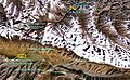 78.96268E 36.26053N nasa kanxiwar.jpg 990 × 609; 200 KB
-
 A Wayfarer in China.djvu 2.834 × 4.126, 418 sayfa; 12,84 MB
-
 Baishan mcp.png 376 × 402; 24 KB
-
 Ban Gioc Falls.jpg 1.024 × 768; 343 KB
-
 Cabcal Sibe beye dasangga siyan.jpg 202 × 110; 10 KB
-
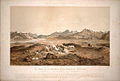 Chain-of-kuenluen-from-sumgal1857a.jpg 1.020 × 686; 448 KB
-
 Changma Basin location.png 2.049 × 822; 194 KB
-
 China grottoes.png 1.193 × 870; 270 KB
-
 China Sacred Mountains.png 1.045 × 737; 428 KB
-
 Chinese valley.jpg 800 × 533; 115 KB
-
 ChineseScientistYangHuanmingOct05.jpg 640 × 480; 53 KB
-
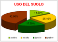 CINA-USODELSUOLO.PNG 658 × 474; 17 KB
-
 Composition of sands in Minshashan Dunhuang China.jpg 4.000 × 3.000; 4,84 MB
-
 DeTianWaterFall.jpg 1.600 × 1.063; 330 KB
-
 Du Halde - Description géographique, historique, chronologique, politique et physique de l’Empire de la Chine, tome 1, 1735.djvu 4.267 × 7.240, 738 sayfa; 84,41 MB
-
 General View of Extra-Provincial China.png 1.573 × 900; 283 KB
-
 Geographic Surveys by the Imperial Order WDL4662.jpg 1.552 × 1.024; 241 KB
-
 Hexigten location.jpg 800 × 459; 148 KB
-
 High above Shanghi (8008078864).jpg 2.400 × 1.548; 997 KB
-
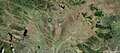
 Hongyuan Grasland.JPG 4.000 × 3.000; 2,2 MB
-
 Inner Mongolia Map.png 1.090 × 750; 1,57 MB
-
 Juhuatan park.jpg 1.280 × 960; 792 KB
-
 Location of Jingjinji(red) in China.png 5.000 × 3.520; 1,15 MB
-
 MahayanaMapchinese.GIF 958 × 659; 20 KB
-
 NanyangBaseNASA.jpg 1.207 × 529; 162 KB
-
 National Intelligence Survey Gazetteer for Communist China CIA-RDP01-00707R000100130002-2.pdf 1.275 × 1.650, 263 sayfa; 13,94 MB
-
 Nostoc flagelliforme fake.jpg 1.024 × 768; 392 KB
-
 PRcoords Cheatsheet.pdf 1.752 × 1.239; 24 KB
-
 PRcoords Cheatsheet.svg 1.052 × 744; 90 KB
-
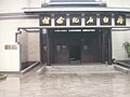 Qibaishi jinianguan.jpg 1.280 × 960; 867 KB
-
 Sdle2001 view from 2 meter2.jpg 528 × 230; 16 KB
-
 Sixteen Prefectures.png 958 × 842; 656 KB
-
 Socotra Rock location jpn.png 1.650 × 1.128; 226 KB
-
 Spratly & Paracel Islands.png 1.280 × 910; 254 KB
-
 Turpan Depression, nestled at the foot of China’s Bogda Mountains.jpg 3.648 × 3.648; 3,93 MB
-
 Xinhui G325.JPG 1.024 × 768; 168 KB
-
 Yuetangqu.JPG 1.200 × 1.600; 329 KB
-
 이어도-Ieodo (en-socotra rock).png 1.650 × 1.128; 345 KB


.jpg)


_in_China.png)


.png)