Category:Satellite pictures of China
Jump to navigation
Jump to search
Countries of Asia: Afghanistan · Armenia‡ · Azerbaijan‡ · Bahrain · Bangladesh · Bhutan · Brunei · Cambodia · People's Republic of China · Cyprus‡ · East Timor · Egypt‡ · Georgia‡ · India · Indonesia‡ · Iran · Iraq · Israel · Japan · Jordan · Kazakhstan‡ · Kuwait · Kyrgyzstan · Laos · Lebanon · Malaysia · Maldives · Mongolia · Myanmar · Nepal · North Korea · Oman · Pakistan · Philippines · Qatar · Russia‡ · Saudi Arabia · Singapore · South Korea · Sri Lanka · Syria · Tajikistan · Thailand · Turkey‡ · Turkmenistan · United Arab Emirates · Uzbekistan · Vietnam · Yemen
Limited recognition: Taiwan · State of Palestine – Other territories: British Indian Ocean Territory · Hong Kong
‡: partly located in Asia
Limited recognition: Taiwan · State of Palestine – Other territories: British Indian Ocean Territory · Hong Kong
‡: partly located in Asia
Subcategories
This category has the following 27 subcategories, out of 27 total.
*
H
I
K
- Kompsat images of China (1 F)
L
- Landsat images of China (63 F)
M
N
- China at night seen from space (12 F)
Q
S
T
X
Y
Z
- Satellite pictures of Zhejiang (14 F)
Pages in category "Satellite pictures of China"
This category contains only the following page.
L
Media in category "Satellite pictures of China"
The following 200 files are in this category, out of 563 total.
(previous page) (next page)-
 106.71680E 26.58748N.png 1,280 × 706; 1.37 MB
-
 113.01085E 28.02336Nczt.jpg 600 × 686; 185 KB
-
 121.55000E 29.86667N Ningbo.png 812 × 616; 355 KB
-
 China at night by VIIRS.jpg 1,610 × 1,158; 1.52 MB
-
 2017 Sichuan landslide.gif 450 × 349; 223 KB
-
 2021 Satellite image of Yan'an(延安).png 1,204 × 806; 2.27 MB
-
 2021 Satellite image of Yan'an(延安)closer.png 1,219 × 835; 2.29 MB
-
 Alluvial fan in Tsinghai-annotated.jpg 556 × 537; 238 KB
-
 Alluvial fan in Tsinghai.jpg 3,060 × 2,036; 834 KB
-
 Anshan 122.98963E 41.11414N.jpg 1,280 × 958; 272 KB
-
 Asdust tmo 2008061 lrg.jpg 3,600 × 2,800; 966 KB
-
 Asia dust 2000-04-07.jpg 3,319 × 2,750; 2.31 MB
-
 Asian Dust, NASA aerospace photography.jpg 2,460 × 2,300; 1.66 MB
-
 Baoding 115.48629E 38.85695N.jpg 1,280 × 958; 350 KB
-
 Bohai Bay, China ESA213619.jpg 1,620 × 1,620; 663 KB
-
 Bohai Bay, China ESA213619.tiff 1,620 × 1,620; 7.54 MB
-
 Bohai sea aquaculture planet labs satellite image.jpg 2,659 × 1,995; 1.59 MB
-
 Central Asia1.jpg 3,712 × 5,150; 6.79 MB
-
 Changchun 125.32286E 43.87998N.jpg 1,280 × 958; 233 KB
-
 Changchun Gymnasium.png 502 × 379; 330 KB
-
 Changshan Islands and offshore oil platform in fire.jpg 10,980 × 10,980; 65.97 MB
-
 Changshan Islands.jpg 1,904 × 3,644; 6.23 MB
-
 China 100.78713E 35.63718N.jpg 1,280 × 958; 226 KB
-
 China 2017 01 25 (32482168976).jpg 2,640 × 2,704; 1.25 MB
-
 China 2017 12 25 (25482358108).jpg 3,200 × 1,664; 1.14 MB
-
 China 2017 12 28 (25482356148).jpg 3,200 × 1,664; 977 KB
-
 China 25th and 28th December 2017 (38646070334).jpg 1,920 × 1,080; 122 KB
-
 China BMNG.jpg 3,328 × 2,881; 6.76 MB
-
 China from space.png 1,527 × 970; 1.93 MB
-
 China FuQing.jpg 635 × 450; 52 KB
-
 China nasa.jpg 1,000 × 574; 97 KB
-
 China satellite.png 1,278 × 956; 2.02 MB
-
 China Three Kingdoms.jpg 996 × 572; 90 KB
-
 China Three Kingdoms.png 1,678 × 964; 2.19 MB
-
 China tmo 2008029 lrg.jpg 4,000 × 4,000; 4.56 MB
-
 China.A2001313.0330.250m.jpg 4,400 × 5,800; 3.05 MB
-
 China.A2002007.0310.250m.jpg 8,000 × 6,000; 5.23 MB
-
 China.A2002102.0225.1km.jpg 750 × 1,000; 80 KB
-
 China.A2002104.0350.250m.jpg 5,200 × 4,000; 2.42 MB
-
 China.A2002249.0255.250m.jpg 4,400 × 3,400; 2.14 MB
-
 China.A2004040.0245.250m.jpg 5,600 × 7,200; 5.4 MB
-
 China.A2004050.0500.250m.jpg 4,000 × 5,200; 1.6 MB
-
 China.A2004056.0245.250m.jpg 4,400 × 3,400; 1.16 MB
-
 China.TMO2002163 lrg.jpg 2,600 × 2,000; 967 KB
-
 ChinaABomb 2.jpg 600 × 400; 66 KB
-
 ChinaDustOverEastAsia.jpg 2,100 × 2,100; 877 KB
-
 Chinese Solar Farm, Golmud, China by Planet Labs.jpg 3,646 × 2,734; 1.54 MB
-
 Chongqing, China ESA23338300.jpeg 2,126 × 2,126; 1.56 MB
-
 Chongqing, China ESA23338300.tiff 5,314 × 5,314; 80.83 MB
-
 Coal Mines, Shanxi Province China - Planet Labs Satellite image.jpg 1,200 × 900; 421 KB
-
 Datong 113.28918E 40.08527N.jpg 1,280 × 958; 245 KB
-
 Dazhou ali 2011267 geo.tif 2,813 × 4,220; 19.37 MB
-
 Dazhou ali 2011267 lrg.jpg 2,813 × 4,220; 3.2 MB
-
 Desertification Control Project, Ningxia China - Planet Labs satellite image.jpg 3,510 × 2,633; 2.26 MB
-
 Dongguan Arena.png 398 × 373; 236 KB
-
 Dongting Lake NASA.jpg 884 × 730; 134 KB
-
 Drought causes Yangtze to shrink ESA24418369.jpeg 1,920 × 1,080; 2.83 MB
-
 Dust in Northwestern China 2010-04-25.jpg 720 × 480; 77 KB
-
 Dust over China 2010-03-12 lrg.jpg 7,400 × 5,600; 4.22 MB
-
 Dust over China 2010-03-12.jpg 720 × 480; 235 KB
-
 Dust storm in Taklimakan Desert, western China - November 17, 2013.jpg 5,800 × 4,400; 4.98 MB
-
 Dust storm in the Gobi Desert, China (8568589729).jpg 7,800 × 6,000; 5.57 MB
-
 Duststorm over Beijing ESA23214619.jpeg 1,920 × 2,560; 3.62 MB
-
 East China Sea 2017 02 25 (33105952485).jpg 4,806 × 1,534; 1.16 MB
-
 EChinaspace.jpg 2,143 × 1,269; 632 KB
-
 EHDC2 (iss069e000174).jpg 4,928 × 2,768; 6.21 MB
-
 Envisat optical view of China haze ESA201082.tiff 1,062 × 1,501, 2 pages; 4.61 MB
-
 Envisat shows Poyang Lake (Poyang Hu) in China ESA203949.jpg 1,024 × 1,024; 301 KB
-
 Envisat shows Poyang Lake (Poyang Hu) in China ESA203949.tiff 1,097 × 1,097; 3.47 MB
-
 Envisat vs. Sentinel-1 radar ESA312147.tiff 2,296 × 1,436; 9.46 MB
-
 Envisat vs. Sentinel-1 radar.jpg 2,296 × 1,436; 1.13 MB
-
 Envisat's ASAR sees Tianjin, China's third largest city ESA216958.jpg 1,023 × 1,001; 353 KB
-
 ESC large ISS006 ISS006-E-43366.JPG 2,122 × 1,405; 1.45 MB
-
 Evaporate Mine, Inner Mongolia China - Planet Labs satellite image.jpg 1,200 × 900; 425 KB
-
 Fuxin 121.67134E 41.99069N.jpg 1,280 × 958; 273 KB
-
 Geography of Macau.png 992 × 605; 828 KB
-
 Giant Brown Cloud Storm over Asia (NASA).jpg 640 × 480; 120 KB
-
 Gobi 106.49229E 41.93582N annotated.png 1,280 × 958; 2.45 MB
-
 Gobi 106.49229E 41.93582N.png 1,280 × 958; 2.1 MB
-
 Great Wall of China, Satellite image red composite.jpg 1,638 × 739; 1.44 MB
-
 Great Wall of China, Satellite image.jpeg 800 × 800; 224 KB
-
 Gulf of Tonkin (cropped).jpg 3,629 × 2,041; 2.28 MB
-
 Gulf of Tonkin.jpg 5,912 × 3,163; 2.53 MB
-
 Gwc-from-space.jpg 500 × 1,501; 338 KB
-
 Hainan NASA Terra MODIS 2020-11-13.jpg 1,553 × 1,349; 1.24 MB
-
 Hainan satellite.JPG 992 × 735; 129 KB
-
 Hainan tmo 07feb05 250m.jpg 1,692 × 1,332; 2.02 MB
-
 Han River, Hubei Province China - Planet Labs satellite image.jpg 1,200 × 900; 305 KB
-
-
 Harbin, China, and vicinities, near natural colors, LandSat-5, 2010-09-22.jpg 2,519 × 2,039; 1.75 MB
-
 Heavy Snow in Eastern China.jpg 4,400 × 5,400; 5.47 MB
-
 Hefei 117.27992E 31.86362N.jpg 1,280 × 958; 272 KB
-
 Hengduan tmo 2000360 lrg.jpg 3,556 × 4,448; 4.4 MB
-
 Himalaya 85.30820E 32.11063N.jpg 1,280 × 958; 293 KB
-
 Himalaya composite.jpg 1,947 × 981; 659 KB
-
 Himalayan Glacier, Southern China 2009-12-25. lrg.jpg 3,000 × 3,000; 4.41 MB
-
 Himalayan Glacier, Southern China 2009-12-25.jpg 720 × 720; 355 KB
-
 Hindu Kush and Karakoram peaks annotated (NASA satellite Terra MODIS).png 1,181 × 606; 1.42 MB
-
 Hongshan Arena.png 521 × 385; 377 KB
-
 Huang He Delta, China, landuse 1979 to 2010.png 784 × 560; 1.27 MB
-
 Hymalayas 86.15103E 31.99726N.jpg 1,280 × 958; 288 KB
-
 Industrial Infrastructure, China by Planet Labs.jpg 3,034 × 2,276; 2.23 MB
-
 ISS064-E-36822 - View of Earth.jpg 5,568 × 3,712; 1.92 MB
-
 ISS064-E-36823 - View of Earth.jpg 5,568 × 3,712; 1.92 MB
-
 ISS064-E-36826 - View of Earth.jpg 3,712 × 5,568; 1.94 MB
-
 ISS064-E-36828 - View of Earth.jpg 3,712 × 5,568; 1.85 MB
-
 ISS064-E-37179 - View of Earth.jpg 5,500 × 3,675; 2.96 MB
-
 Kazak-Chinese border near Tacheng.jpg 720 × 480; 242 KB
-

-
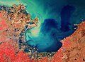 Laizhou Bay, China ESA23271000.jpeg 19,600 × 14,192; 10.91 MB
-
 Laizhou Bay, China ESA23271000.tiff 15,000 × 10,861; 342.95 MB
-
 Lanzhou 103.79190E 36.05642N.jpg 1,280 × 958; 239 KB
-
 Lanzhou gaseous diffusion plant.png 6,061 × 4,644; 3.44 MB
-
 Leizhou Peninsula.jpeg 3,523 × 4,192; 4.88 MB
-
 Leizhou peninsula.jpg 1,397 × 1,332; 517 KB
-
 Macau, China.jpg 2,048 × 1,365; 2.32 MB
-
 Mar Amarillo - BM WMS 2004.jpg 1,060 × 989; 237 KB
-
 Mar de China Meridional - BM WMS 2004.jpg 1,060 × 989; 251 KB
-
 Mar de China Oriental - BM WMS 2004.jpg 1,060 × 989; 256 KB
-
 MarAmarilloGuarani.jpg 1,060 × 989; 136 KB
-
 Nansi Lake NASA.jpg 1,032 × 744; 207 KB
-
 NASA-Himalaya-Tibet.jpg 686 × 524; 432 KB
-
 Ningbo 121.32048E 29.71565N.png 578 × 732; 1.14 MB
-
 North and South Korea at night.jpg 4,256 × 2,832; 4.22 MB
-
 Northern China - Envisat.jpg 1,920 × 1,269; 1.5 MB
-
 Offshore oil platform in fire near Changshan Islands (cropped).jpg 816 × 574; 457 KB
-
 Offshore oil platform in fire near Changshan Islands.jpg 2,715 × 1,671; 3.24 MB
-
 Paektu-san.jpg 3,032 × 2,004; 5.21 MB
-
 Panda Solar Power Plant Datong 2017 09 08 (37246736875).jpg 1,986 × 1,393; 322 KB
-
 Panda Solar Station SkySat.jpg 2,853 × 1,957; 952 KB
-
 Pollution over east China.jpg 6,000 × 4,600; 2.12 MB
-
 Poyang Lake ESA364932.jpg 2,000 × 2,007; 5.99 MB
-
 Poyang Lake ESA364932.tiff 6,956 × 6,979; 138.92 MB
-
 Qingdao, China ESA349719.jpg 2,000 × 1,542; 4.39 MB
-
 Qingdao, China ESA349719.tiff 5,840 × 4,504; 75.28 MB
-
 Rainbowmtnspt1 oli 2020261 lrg.jpeg 977 × 814; 1.04 MB
-
 Rainbowmtnspt2 oli 2020261 lrg.jpeg 1,406 × 937; 1.64 MB
-
 RE mine in Baiyun Ebo, Inner Mongolia.jpg 1,306 × 1,066; 295 KB
-

-
 Rongbuk Glacier animation.gif 990 × 610; 1.68 MB
-
 SandSpillsInYellowSea.jpg 750 × 854; 71 KB
-
 Satellite image of Conson Gymnasium.png 430 × 380; 232 KB
-
 Satellite picture of Heaven Lake - ISS041-E-78210.jpg 2,076 × 2,011; 683 KB
-
 Satellitenbild Nordchina und Mongolei-2.jpg 2,553 × 1,783; 4.7 MB
-
 Satellitenbild Nordchina und Mongolei.jpg 2,553 × 1,783; 2.1 MB
-
 Severe Tropical Storm Chanthu at peak strength (07-21-10).jpg 5,600 × 7,200; 4.37 MB
-
 Shandong Arena.png 510 × 434; 313 KB
-
 Shenyang 123.38236E 41.77365N.jpg 1,280 × 958; 278 KB
-
 Shenyang from International Space Station.jpg 3,032 × 2,008; 1.7 MB
-
 Shenzhen 114.09549E 22.54895N.jpg 1,280 × 958; 249 KB
-
 Shenzhen Dayun Arena.png 374 × 421; 235 KB
-
 Sichuan clouds.jpg 3,200 × 4,200; 2.89 MB
-
 Sichuan Haze.jpg 4,400 × 3,400; 3.97 MB
-
 SonghuaRiver ASTER 20020401.jpg 2,124 × 2,733; 1.82 MB
-
 SpaceX Dragon 16 (cropped).jpg 1,866 × 1,253; 692 KB
-
 SpaceX Dragon 16.jpg 5,568 × 3,712; 3.31 MB
-
 Spring Sandstorm Scours China 2010-03-20.jpg 720 × 480; 162 KB
-
 STS001-009-0096 - View of China (Raw scan).tif 4,400 × 4,600; 57.91 MB
-
 STS001-009-0097 - View of China (Raw scan).tif 4,400 × 4,600; 57.91 MB
-
 STS001-009-0098 - View of China (Raw scan).tif 4,400 × 4,600; 57.91 MB
-
 STS001-009-0099 - View of China (Raw scan).tif 4,400 × 4,600; 57.91 MB
-
 STS001-009-0100 - View of China (Raw scan).tif 4,400 × 4,600; 57.91 MB
-
 STS001-009-0101 - View of China (Raw scan).tif 4,400 × 4,600; 57.91 MB
-
 STS001-009-0102 - View of China (Raw scan).tif 4,400 × 4,600; 57.91 MB
-
 STS001-009-0103 - View of China (Raw scan).tif 4,400 × 4,600; 57.91 MB
-
 STS001-009-0104 - View of China (Raw scan).tif 4,400 × 4,600; 57.91 MB
-
 STS001-009-0105 - View of China (Raw scan).tif 4,400 × 4,600; 57.91 MB
-
 STS001-009-0106 - View of China (Raw scan).tif 4,400 × 4,600; 57.91 MB
-
 STS001-009-0107 - View of China (Raw scan).tif 4,400 × 4,600; 57.91 MB
-
 STS001-009-0108 - View of China (Raw scan).tif 4,400 × 4,600; 57.91 MB
-
 STS001-009-0109 - View of China (Raw scan).tif 4,400 × 4,600; 57.91 MB
-
 STS001-012-0353 - View of China (Raw scan).tif 4,400 × 4,600; 57.91 MB
-
 STS001-012-0355 - View of China (Raw scan).tif 4,400 × 4,600; 57.91 MB
-
 STS001-012-0357 - View of China (Raw scan).tif 4,400 × 4,600; 57.91 MB
-
 STS001-012-0358 - View of China (Raw scan).tif 4,400 × 4,600; 57.91 MB
-
 STS001-012-0359 - View of China (Raw scan).tif 4,400 × 4,600; 57.91 MB
-
 STS001-012-0360 - View of China (Raw scan).tif 4,400 × 4,600; 57.91 MB
-
 STS001-012-0361 - View of China (Raw scan).tif 4,400 × 4,600; 57.91 MB
-
 STS001-012-0362 - View of China (Raw scan).tif 4,400 × 4,600; 57.91 MB
-
 STS001-012-0363 - View of China (Raw scan).tif 4,400 × 4,600; 57.91 MB
-
 STS001-012-0363 - View of China (Retouched).tif 4,144 × 4,136; 35.2 MB
-
 STS001-012-0364 - View of China (Raw scan).tif 4,400 × 4,600; 57.91 MB
-
 STS001-012-0365 - View of China (Raw scan).tif 4,400 × 4,600; 57.91 MB
-
 STS001-012-0366 - View of China (Raw scan).tif 4,400 × 4,600; 57.91 MB
-
 STS001-012-0367 - View of China (Raw scan).tif 4,400 × 4,600; 57.91 MB
-
 STS002-10-588 - View of China (Raw scan).tif 4,393 × 4,600; 57.82 MB
-
 STS002-10-588 - View of China.jpg 4,393 × 4,600; 1.38 MB
-
 STS002-10-589 - View of China (Raw scan).tif 4,393 × 4,600; 57.82 MB
-
 STS002-10-589 - View of China.jpg 4,393 × 4,600; 1.38 MB
-
 STS002-10-590 - View of China (Raw scan).tif 4,393 × 4,600; 57.82 MB
-
 STS002-10-590 - View of China.jpg 4,393 × 4,600; 1.15 MB
-
 STS002-10-591 - View of China (Raw scan).tif 4,393 × 4,600; 57.82 MB
-
 STS002-10-591 - View of China.jpg 4,393 × 4,600; 1.23 MB
-
 STS002-10-592 - View of China (Raw scan).tif 4,393 × 4,600; 57.82 MB
-
 STS002-10-592 - View of China.jpg 4,393 × 4,600; 1.29 MB
-
 STS002-10-593 - View of China (Raw scan).tif 4,393 × 4,600; 57.82 MB
-
 STS002-10-593 - View of China.jpg 4,393 × 4,600; 1.32 MB
-
 STS002-10-594 - View of China (Raw scan).tif 4,393 × 4,600; 57.82 MB
-
 STS002-10-594 - View of China.jpg 4,393 × 4,600; 1.2 MB
-
 STS002-10-595 - View of China (Raw scan).tif 4,393 × 4,600; 57.82 MB


.jpg)
.jpg)
.jpg)
.jpg)


.jpg)


.jpg)
_in_China_ESA203949.jpg)


.jpg)


.jpg)


.jpg)


.png)


_-_Fort_Bayard_-_P%C3%A9ninsule_de_Leizhou.png)


.jpg)


.jpg)


.jpg)


.jpg)


.jpg)


.jpg)