Category:Gibraltar Peak (Australian Capital Territory)
Jump to navigation
Jump to search
English: Gibraltar Peak is a mountain located 26.4 kilometres (16.4 miles) from Canberra. Gibraltar Peak is 1,038 metres (3,406 feet) above sea level, and is the 45th highest mountain in the Australian Capital Territory. There are two tracks leading up to the summit of the mountain, the longer being 13 kilometres (8.1 mi) and the shorter being 8 kilometres (5.0 mi). (→Gibraltar Peak (Canberra))
mountain in Australia  | |||||
| Upload media | |||||
| Instance of | |||||
|---|---|---|---|---|---|
| Location | Australian Capital Territory, AUS | ||||
| Elevation above sea level |
| ||||
 | |||||
Media in category "Gibraltar Peak (Australian Capital Territory)"
The following 12 files are in this category, out of 12 total.
-
 Birrigai viewed from the top of Gibraltar Peak.jpg 4,000 × 3,000; 3.72 MB
-
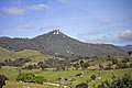 Gibraltar Peak and Gibraltar Creek in the foreground.jpg 2,000 × 1,333; 2.1 MB
-
 Looking north-northwest from Gibraltar Peak (1).jpg 3,264 × 2,448; 3.24 MB
-
 Looking north-northwest from Gibraltar Peak (2).jpg 3,264 × 2,448; 3.2 MB
-
 Looking north-northwest from Gibraltar Peak.jpg 4,000 × 3,000; 2.19 MB
-
 Looking northwest from Gibraltar Peak.jpg 3,264 × 2,448; 3.48 MB
-
 Looking towards Canberra from Gibraltar Peak (1).jpg 3,264 × 2,448; 2.74 MB
-
 Looking towards Canberra from Gibraltar Peak.jpg 4,000 × 3,000; 1.99 MB
-
 Looking towards Canberra from the viewing platform on Gibraltar Peak.jpg 3,264 × 2,448; 2.95 MB
-
 Paddys River viewed from Gibraltar Peak.jpg 2,000 × 1,333; 3.07 MB
-
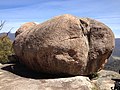 Rock formations on top of Gibraltar Peak (1).jpg 3,264 × 2,448; 4.08 MB
-
 Rock formations on top of Gibraltar Peak.jpg 2,448 × 3,264; 4.4 MB


.jpg)
.jpg)


.jpg)


.jpg)
