Category:Great Henny
Jump to navigation
Jump to search

village in Essex, United Kingdom | |||||
| Upload media | |||||
| Instance of | |||||
|---|---|---|---|---|---|
| Location | Braintree, Essex, East of England, England | ||||
 | |||||
Subcategories
This category has the following 2 subcategories, out of 2 total.
H
Media in category "Great Henny"
The following 58 files are in this category, out of 58 total.
-
 "Birdbox" near St Mary's church - geograph.org.uk - 5199964.jpg 5,202 × 3,465; 4.06 MB
-
 Churchyard lych gate, Great Henny - geograph.org.uk - 4371570.jpg 640 × 480; 171 KB
-
 Cottage by Great Henny church - geograph.org.uk - 4368003.jpg 640 × 480; 113 KB
-
 Country Lane - geograph.org.uk - 2821509.jpg 1,024 × 768; 303 KB
-
 Country Road - geograph.org.uk - 2844397.jpg 1,024 × 768; 342 KB
-

-

-
 Countryside - geograph.org.uk - 2821480.jpg 1,024 × 768; 239 KB
-

-
 Footpath - geograph.org.uk - 2822181.jpg 1,024 × 768; 193 KB
-
 Footpath Between Paddocks - geograph.org.uk - 2821690.jpg 1,024 × 768; 371 KB
-
 Footpath Sign - geograph.org.uk - 2822182.jpg 1,024 × 768; 180 KB
-
 Gate above Thorneycroft farm - geograph.org.uk - 5199979.jpg 5,184 × 3,456; 7.33 MB
-
 Graph showing population changes in Great Henny.png 484 × 307; 8 KB
-
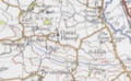 GREAT HENNY MAP.PNG 406 × 249; 228 KB
-
 Great Hickbush - geograph.org.uk - 5199706.jpg 5,184 × 3,456; 5.47 MB
-
 House - geograph.org.uk - 2844342.jpg 1,024 × 768; 346 KB
-
 Lane to Great Henny - geograph.org.uk - 1463548.jpg 640 × 480; 99 KB
-
 Looking over wheat field to small wood, Great Henny - geograph.org.uk - 4982645.jpg 3,648 × 2,432; 4.4 MB
-
 Looking towards Lamarsh Hill - geograph.org.uk - 2661530.jpg 3,648 × 2,736; 1.7 MB
-
 Losh House Farm Barn - geograph.org.uk - 1250217.jpg 640 × 428; 108 KB
-
 Loshes Brook - geograph.org.uk - 1250199.jpg 428 × 640; 119 KB
-
 Loshes Primroses - geograph.org.uk - 1250205.jpg 428 × 640; 100 KB
-
 Loshes Reserve - geograph.org.uk - 1250173.jpg 428 × 640; 118 KB
-
 Lychgate at St Mary's church, Great Henny - geograph.org.uk - 5199969.jpg 4,473 × 2,930; 4.86 MB
-
 Mighty Pylon - geograph.org.uk - 2844402.jpg 768 × 1,024; 211 KB
-
 Mirror Mirror - geograph.org.uk - 2821531.jpg 1,024 × 768; 244 KB
-
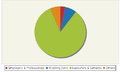
 Occupational Chart.png 600 × 400; 22 KB
-
 Ordnance Survey Cut Mark - geograph.org.uk - 4450784.jpg 4,000 × 3,000; 4.33 MB
-
 Over The Bridge - geograph.org.uk - 2821475.jpg 768 × 1,024; 380 KB
-
 Path in Loshes Reserve, Great Henny - geograph.org.uk - 3964848.jpg 3,648 × 2,736; 5.06 MB
-
 Path towards St Mary's church, Great Henny - geograph.org.uk - 5199952.jpg 5,184 × 3,456; 7.47 MB
-
 Permissive path through young tree plantation, Great Henny - geograph.org.uk - 4982647.jpg 3,648 × 2,736; 4.54 MB
-
 Ploughed field and power lines - geograph.org.uk - 5199722.jpg 5,184 × 3,456; 6.47 MB
-
 Pylon Junction, Great Henny - geograph.org.uk - 3964838.jpg 2,736 × 3,648; 2.79 MB
-
 Pylons - geograph.org.uk - 2844330.jpg 768 × 1,024; 182 KB
-
 River Stour - geograph.org.uk - 2844355.jpg 1,024 × 768; 271 KB
-
 River Stour and flood plain - geograph.org.uk - 2815899.jpg 2,112 × 2,816; 2.49 MB
-
 River Stour flood plain - geograph.org.uk - 2815578.jpg 2,816 × 2,112; 2.57 MB
-
 Road junction near Great Henny - geograph.org.uk - 5199745.jpg 4,683 × 3,265; 3.18 MB
-
 Road Sign - geograph.org.uk - 2844404.jpg 1,024 × 768; 134 KB
-
 Social Status in Great Henny, 1831.png 502 × 303; 13 KB
-
 St Edmunds Way leading towards Middleton - geograph.org.uk - 5199992.jpg 4,597 × 2,911; 7.53 MB
-
 St Edmunds Way towards Little Hickbush - geograph.org.uk - 5199728.jpg 5,184 × 3,456; 7.15 MB
-
 St Mary, Great Henny - East end - geograph.org.uk - 5516440.jpg 900 × 675; 261 KB
-
 St Mary, Great Henny - Font - geograph.org.uk - 5516451.jpg 653 × 900; 254 KB
-
 St Mary, Great Henny - geograph.org.uk - 5516434.jpg 900 × 678; 203 KB
-
 St Mary, Great Henny - geograph.org.uk - 5516436.jpg 900 × 556; 196 KB
-
 St Mary, Great Henny - geograph.org.uk - 5516438.jpg 900 × 591; 219 KB
-
 St Mary, Great Henny - Sanctuary - geograph.org.uk - 5516444.jpg 900 × 656; 243 KB
-

-
 St Mary, Great Henny - West end - geograph.org.uk - 5516441.jpg 900 × 675; 221 KB
-
 Stile And View - geograph.org.uk - 2844336.jpg 1,024 × 768; 257 KB
-
 The view from the entrance to Dovehouse Farm - geograph.org.uk - 2256237.jpg 3,648 × 2,736; 1.71 MB
-
 Thorncroft Farm, Great Henny - geograph.org.uk - 4371541.jpg 640 × 480; 108 KB
-
 Trees, Stour valley - geograph.org.uk - 4723473.jpg 640 × 428; 106 KB
-
 Undulating farm land - geograph.org.uk - 4367993.jpg 640 × 480; 106 KB
-
 Walnut Tree Cottage - geograph.org.uk - 294211.jpg 640 × 480; 80 KB


