Category:Houthulst
Naar navigatie springen
Naar zoeken springen
gemeente in West-Vlaanderen, België     | |||||
| Media uploaden | |||||
| Is een | |||||
|---|---|---|---|---|---|
| Onderdeel van |
| ||||
| Locatie | Arrondissement Diksmuide, West-Vlaanderen, Vlaams Gewest, België | ||||
| Hoofdplaats |
| ||||
| Officiële taal | |||||
| Bestuurshoofd |
| ||||
| Rechtsvorm |
| ||||
| Inwonertal |
| ||||
| Oppervlakte |
| ||||
| officiële website | |||||
 | |||||
Ondercategorieën
Deze categorie bevat de volgende 11 subcategorieën, van de 11 in totaal.
Media in categorie "Houthulst"
Deze categorie bevat de volgende 26 bestanden, van in totaal 26.
-
 Houthulst vlag.jpg 300 × 202; 11 kB
-
 Houthulst wapen.gif 94 × 104; 5 kB
-
 Houthulst vlag.svg 584 × 394; 110 kB
-
 Blason Houthulst.svg 600 × 660; 33 kB
-
 Bunker 14-18 - 340059 - onroerenderfgoed.jpg 3.052 × 4.208; 1,32 MB
-
 Bunker 14-18 - 340060 - onroerenderfgoed.jpg 4.214 × 3.040; 4,18 MB
-
 Centiemhoek 4 - 33755 - onroerenderfgoed.jpg 591 × 397; 73 kB
-
 Crucifix op de hoek van Slijpstraat en Terreststraat 01.jpg 3.925 × 2.943; 1,94 MB
-
 Crucifix op de hoek van Slijpstraat en Terreststraat 02.jpg 4.331 × 3.248; 2,46 MB
-
 Dorpsstraat straatbeeld - 33763 - onroerenderfgoed.jpg 591 × 443; 57 kB
-
 Gedenkteken regimenten Bos van Houthulst.jpg 1.149 × 528; 326 kB
-
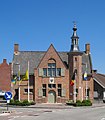 Houthulst Gemeentehuis.jpg 1.978 × 2.269; 2,79 MB
-
 Houthulst Vlag - 22579 - onroerenderfgoed.jpg 1.000 × 1.500; 109 kB
-
 Houthulst wapen.svg 596 × 673; 155 kB
-
 Houthulst Wapenschild - 22580 - onroerenderfgoed.jpg 1.000 × 1.500; 139 kB
-
 Klerken Coppensplein - 2190 - onroerenderfgoed.jpg 480 × 640; 91 kB
-

-

-
 Klerken Smissestraat 1-3 - 33788 - onroerenderfgoed.jpg 591 × 398; 56 kB
-
 Klerken Smissestraat 2-4 - 33789 - onroerenderfgoed.jpg 591 × 399; 69 kB
-
 Kloostermolenstraat - 33829 - onroerenderfgoed.jpg 591 × 443; 51 kB
-
 Kouterstraat 2-4 - 33833 - onroerenderfgoed.jpg 591 × 443; 52 kB
-
 Kroos - panoramio.jpg 3.008 × 2.000; 3,69 MB
-
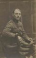 Maurice Florimond Verhaeghe.jpg 1.882 × 3.006; 579 kB
-
 Preiveld R01.jpg 2.304 × 3.072; 7,55 MB
-
 Wind-mills - panoramio.jpg 3.008 × 2.000; 2,79 MB


