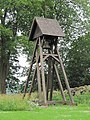
Category:Hägerstads gamla kyrka
Jump to navigation
Jump to search
Svenska: Hägerstads gamla kyrka
| Object location | | View all coordinates using: OpenStreetMap |
|---|
|
This is a category about an ecclesiastical monument in Sweden, number 21300000004546 in the RAÄ buildings database.
|
|
This is a category about a protected building in Sweden, number 21400000087726 in the RAÄ buildings database.
|
church building in Kinda Municipality, Sweden  | |||||
| Upload media | |||||
| Instance of | |||||
|---|---|---|---|---|---|
| Location | Kinda Municipality, Östergötland County, Sweden | ||||
| Diocese | |||||
| Has use |
| ||||
| Occupant | |||||
| Heritage designation |
| ||||
| Inception |
| ||||
 | |||||
Subcategories
This category has only the following subcategory.
Media in category "Hägerstads gamla kyrka"
The following 5 files are in this category, out of 5 total.
-
 Historiska Museet, altar, Holy Family, 2009-07-19.jpg 3,081 × 2,439; 8.43 MB
-
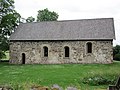 Hägerstads gamla kyrka ext1.jpg 4,000 × 3,000; 3.55 MB
-
 Hägerstads gamla kyrka ext2.jpg 4,000 × 3,000; 3.83 MB
-
 Hägerstads gamla kyrka ext3.jpg 4,000 × 3,000; 3.5 MB
-
 Hägerstads gamla kyrka ext4.jpg 3,000 × 4,000; 4.48 MB


