Category:Ibusuki, Kagoshima
Zur Navigation springen
Zur Suche springen
Stadt in Japan  | |||||
| Medium hochladen | |||||
| Ist ein(e) | |||||
|---|---|---|---|---|---|
| Ort |
| ||||
| Liegt am oder im Gewässer | |||||
| Rechtsform |
| ||||
| Datum der Gründung, Erstellung, Entstehung, Erbauung |
| ||||
| Einwohnerzahl |
| ||||
| Fläche |
| ||||
| Ersetzt |
| ||||
| offizielle Website | |||||
 | |||||
Unterkategorien
Es werden 16 von insgesamt 16 Unterkategorien in dieser Kategorie angezeigt:
In Klammern die Anzahl der enthaltenen Kategorien (K), Seiten (S), Dateien (D)
F
- Flower Park Kagoshima (3 D)
- Fushime Onsen (16 D)
H
I
- Ibusuki City Library (6 D)
K
L
- Lake Ikeda (18 D)
N
P
- Post offices in Ibusuki (5 D)
S
T
- Temples in Ibusuki, Kagoshima (leer)
Y
Medien in der Kategorie „Ibusuki, Kagoshima“
Folgende 76 Dateien sind in dieser Kategorie, von 76 insgesamt.
-
 Emblem of Ibusuki, Kagoshima.jpg 91 × 81; 5 KB
-
 Emblem of Ibusuki, Kagoshima.svg 500 × 500; 3 KB
-
 Flag of Ibusuki Kagoshima.JPG 286 × 217; 13 KB
-
 Flag of Ibusuki, Kagoshima (no text).svg 600 × 400; 5 KB
-
 Flag of Ibusuki, Kagoshima.svg 600 × 400; 3 KB
-
 Ibusuki in Kagoshima Prefecture Ja.svg 395 × 777; 12 KB
-
 Map Ibusuki en.png 1.201 × 801; 34 KB
-
 Chiringashima Island from train at Miyagahama Station 2.jpg 3.941 × 2.956; 3,02 MB
-
 Chiringashima Island from train at Miyagahama Station.jpg 3.994 × 2.995; 2,73 MB
-
 Chiringashima Island from train near Miyagahama Station 2.jpg 3.923 × 2.943; 2,58 MB
-
 Chiringashima Island from train near Miyagahama Station.jpg 3.848 × 2.886; 2,27 MB
-
 COCCOhasimure6910.JPG 4.302 × 2.860; 9,16 MB
-
 Emblem of Ibusuki, Kagoshima (1954–2006).svg 94 × 94; 3 KB
-
 ETH-BIB-Friedlaender-Kratersee des Yamagawa Hafen (Kaimon)-Ans 05420-032-AL-FL.tif 3.213 × 1.836; 16,92 MB
-
 Flag of Former Ibusuki Kagoshima.png 670 × 412; 6 KB
-
 Former Ibusuki Kagoshima chapter.gif 302 × 291; 10 KB
-
 From a clearing (4516163903).jpg 5.184 × 3.456; 8,2 MB
-
 Hirayamanorihiro ascension.jpg 926 × 700; 576 KB
-
 Ibusuki and Kaimon-dake.jpg 1.600 × 1.200; 432 KB
-
 Ibusuki city center area Aerial photograph.2018.jpg 5.559 × 9.097; 19,49 MB
-
 Ibusuki City Hall Yamagawa Branch office.JPG 3.648 × 2.736; 3,97 MB
-
 Ibusuki earthenware.jpg 757 × 972; 128 KB
-
 Ibusuki jinja tyokusiden.JPG 2.048 × 1.536; 661 KB
-
 Ibusuki montage.png 892 × 925; 1,32 MB
-
 Ibusuki Onsen-Kaimon.jpg 3.033 × 1.708; 4,23 MB
-
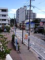
 Ibusuki Station East Plaza.png 900 × 518; 1.000 KB
-
 Ibusuki Volcano Group Relief Map, SRTM-1.jpg 1.600 × 1.200; 658 KB
-
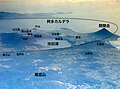 Ibusuki Volcanoes J.jpg 2.700 × 2.000; 801 KB
-
 Ibusuki Volcanoes.jpg 2.700 × 2.000; 756 KB
-
 Ibusuki, michinoeki in kagoshima.jpg 1.632 × 1.224; 828 KB
-
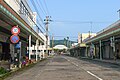 Ibusuki-central-shopping-street.jpg 5.472 × 3.648; 10,05 MB
-
 Ibusuki2.jpg 2.736 × 3.648; 4,77 MB
-
 IbusukiJapanSunset.jpg 500 × 280; 143 KB
-
 IbusukiSeniorCenter.jpg 450 × 252; 131 KB
-
 Kagoshima 20150904123343 (24004013120).jpg 2.048 × 1.536; 560 KB
-
 Kagoshima 20150904145240 (23672778063).jpg 2.048 × 1.536; 486 KB
-
 Kagoshima Pref Road 238 Ibusuki Onsen.JPG 1.440 × 810; 501 KB
-
 Kagoshima prefectural road 241 at KaimonUeno.JPG 3.648 × 2.736; 4,58 MB
-
 Kagoshima-Ibusuki Sweet-potatoes-field.jpg 5.472 × 3.648; 14,55 MB
-
 Kaimon-ueno, Ibusuki.jpg 3.157 × 2.917; 2,98 MB
-
 Kaimondake view - panoramio.jpg 4.928 × 3.264; 6,89 MB
-
 Location of Imaizumi, Kagoshima, Japan.svg 395 × 777; 362 KB
-
 Location of Kaimon, Kagoshima, Japan.svg 395 × 777; 261 KB
-
 Location of Toshinaga, Kagoshima, Japan.svg 395 × 777; 345 KB
-
 Location of Yamagawa, Kagoshima, Japan.svg 395 × 777; 261 KB
-
 Miyagahama Port and Chiringashima Island from train near Miyagahama Station 1.jpg 3.981 × 2.986; 2,07 MB
-
 Miyagahama Port and Chiringashima Island from train near Miyagahama Station 2.jpg 4.023 × 3.017; 2,19 MB
-
 Mount Takeyama (32166577981).jpg 1.024 × 768; 147 KB
-
 Nanohanakan2019.jpg 1.632 × 941; 551 KB
-
 Ontamarandon (Cuisine of Ibusuki, Kagoshima).jpg 2.000 × 1.500; 1,84 MB
-
 Osumi Peninsula and Kagoshima Bay from train at Miyagahama Station 2.jpg 3.989 × 2.992; 3,07 MB
-
 Osumi Peninsula and Kagoshima Bay from train at Miyagahama Station.jpg 3.954 × 2.966; 2,26 MB
-
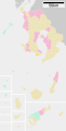
 Population distribution of Ibusuki, Kagoshima, Japan.svg 512 × 256; 22 KB
-
 Rapeseed field, Ibusuki 01.jpg 1.024 × 678; 148 KB
-
 S-DSCF3637.jpg 800 × 450; 74 KB
-
 Satsuma-denshokan.jpg 1.632 × 1.224; 798 KB
-
 SEGA AFTER BURNERⅡ Double cradle type.jpg 2.268 × 2.136; 2,64 MB
-
 Shadow picture of Ibusuki city.svg 600 × 600; 7 KB
-
 Tall palms - panoramio.jpg 4.928 × 3.264; 4 MB
-
 Uomidake antenna - panoramio (1).jpg 3.264 × 4.928; 6,8 MB
-
 Uomidake antenna - panoramio.jpg 4.928 × 3.264; 6,78 MB
-
 View from Uomidake - panoramio (2).jpg 4.928 × 3.264; 6,94 MB
-
 Yamagawa geothermal power station full view.jpg 1.228 × 921; 198 KB
-
 Yamagawafukumoto, Ibusuki, Kagoshima Prefecture 891-0511, Japan - panoramio (1).jpg 3.297 × 2.261; 1,41 MB
-
 Yunosato.jpg 2.048 × 1.536; 712 KB
-
 九州自然歩道 - panoramio.jpg 1.600 × 900; 331 KB
-
 指宿 - panoramio (1).jpg 2.048 × 1.536; 833 KB
-
 指宿 - panoramio - shikabane taro.jpg 1.024 × 695; 211 KB
-
 指宿 - panoramio.jpg 1.024 × 688; 254 KB
-
 指宿 すなむし - panoramio.jpg 2.304 × 1.296; 753 KB
-
 指宿市の郊外にある古典的なアーキテクチャ - panoramio.jpg 1.200 × 1.600; 883 KB
-
 指宿枕崎線の沿線風景 04.jpg 1.024 × 576; 251 KB
-
 指宿枕崎線の沿線風景 13.jpg 1.024 × 767; 148 KB
-
 指宿湾 - panoramio.jpg 2.304 × 1.296; 764 KB
-
 砂州の道 - panoramio.jpg 1.024 × 684; 364 KB
-
 鹿児島湾から薩摩半島南端部を望む Japan 2015 (23008785600).jpg 3.008 × 2.000; 1,89 MB


.jpg)


.jpg)

.jpg)


.jpg)


.jpg)
.svg)
.svg)
.jpg)
.jpg)
.jpg)
.jpg)
.jpg)