Category:Islands of Greenland
Zur Navigation springen
Zur Suche springen
Wikimedia-Kategorie | |||||
| Medium hochladen | |||||
| Ist ein(e) | |||||
|---|---|---|---|---|---|
| Kategorie kombiniert die Themen | |||||
| Grönland | |||||
Größte Insel der Erde und autonomer Teil des Königreiches Dänemark  modeło virtual   .svg)  | |||||
| Aussprache (Audiodatei) | |||||
| Ist ein(e) |
| ||||
| Ist Teil von | |||||
| Ort | Königreich Dänemark | ||||
| Hauptstadt | |||||
| Regierungsform |
| ||||
| Gesetzgebende Körperschaft | |||||
| Amtssprache | |||||
| Hymne |
| ||||
| Währung | |||||
| Staatsoberhaupt |
| ||||
| Leiter der Regierung oder Verwaltung |
| ||||
| Datum der Gründung, Erstellung, Entstehung, Erbauung |
| ||||
| Zeitpunkt der Entdeckung oder Erfindung |
| ||||
| Höchster Punkt |
| ||||
| Einwohnerzahl |
| ||||
| Fläche |
| ||||
| Ersetzt |
| ||||
| Top-Level-Domain | |||||
| Verschieden von | |||||
| Höchsttemperatur |
| ||||
| Historische Tiefsttemperatur |
| ||||
| offizielle Website | |||||
 | |||||
Unterkategorien
Es werden 55 von insgesamt 55 Unterkategorien in dieser Kategorie angezeigt:
In Klammern die Anzahl der enthaltenen Kategorien (K), Seiten (S), Dateien (D)
*
- River islands in Greenland (2 D)
- Skerries in Greenland (5 D)
A
- Akia Island (2 D)
- Akuliaruseq Island (1 D)
- Appat Island (7 D)
C
- Cape Farewell Archipelago (4 D)
- Clavering Ø (2 D)
D
G
- Geographical Society Island (3 D)
- Greenland Island (3 D)
H
- Hovgaard Island (Greenland) (2 D)
I
- Ikerasak Island (2 D)
- Ikermiut Island (1 D)
- Illoorfik Island (1 D)
- Inussullissuaq Island (3 D)
- Itissaalik Island (1 D)
K
- Kaffeklubben Island (1 D)
- Kittorsaq Island (1 D)
L
- Lynn Island (1 D)
M
- Mernoq Island (1 D)
- Milne Land (3 D)
N
- Nasaussaq Island (1 D)
- Nutaarmiut Island (2 D)
Q
- Qallunaat Island (2 D)
- Qeqertarsuatsiaq Island (2 D)
- Qullikorsuit Island (3 D)
S
- Saarlia Island (1 D)
- Salleq Island (6 D)
- Salliaruseq Island (7 D)
- Saqqarlersuaq Island (3 D)
- Sarfannguit Island (3 D)
- Saunders Island, Greenland (6 D)
- Sermersut Island (1 D)
- Shannon Island (1 D)
- Simiutaq Island (4 D)
- Skjoldungen (3 D)
- Sugar Loaf Island (2 D)
T
- Timilersua Island (2 D)
U
- Upernivik Island (3 D)
- Uummannaq Island (12 D)
W
- Warming Island (2 D)
Y
- Ymer Island (14 D)
Medien in der Kategorie „Islands of Greenland“
Folgende 25 Dateien sind in dieser Kategorie, von 25 insgesamt.
-
 Aappilattoq (Upernavik) banner.jpg 2.100 × 300; 366 KB
-
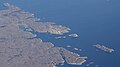 Atammik-aerial.jpg 3.872 × 2.176; 2,49 MB
-
 Bjorlingo.png 948 × 662; 622 KB
-
 Caledonian orogeny fold in King Oscar Fjord.jpg 2.936 × 992; 795 KB
-
 EG1967 0053.jpg 1.622 × 914; 523 KB
-
 Ella Island, East Greenland, august 2007.jpg 2.731 × 1.608; 1,24 MB
-
 Eriksfjord.jpg 640 × 480; 44 KB
-
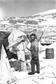
 FMIB 43811 Dragging the boats to the Illuidlek Island.jpeg 1.472 × 943; 518 KB
-
 FMIB 43824 Germania on Sabine Island.jpeg 1.351 × 749; 382 KB
-
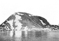
 FMIB 43834 Depot on Kuhn Island.jpeg 813 × 589; 206 KB
-
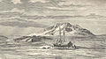
 FMIB 43843 Ruined Esquimaux Huts on Sabine Island.jpeg 822 × 727; 279 KB
-
 Greely Frozen in.JPG 1.878 × 1.290; 1,67 MB
-
 Greenland - panoramio (1).jpg 1.712 × 2.288; 3,31 MB
-
 Greenland Island.jpg 867 × 687; 209 KB
-
 Ike warming Waco.JPG 834 × 1.251; 626 KB
-
 Ilimanaq-aerial.jpg 3.000 × 1.776; 1,33 MB
-
 Kangersuatsiaq.jpg 3.372 × 1.000; 890 KB
-
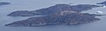
 Lindhard Island 2021-08-12-23 59 Sentinel-2 L1C.jpg 642 × 431; 154 KB
-
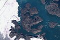
 Milne Land NASA.jpg 1.024 × 702; 173 KB
-
 Milneland.jpg 1.000 × 722; 67 KB
-
 Napasoq-aerial.jpg 3.872 × 2.176; 2,2 MB
-
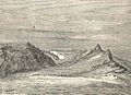
 Pendulum Islands.png 437 × 339; 288 KB
-
 Qalorngoorner Ridge.JPG 1.141 × 624; 190 KB
-
 Ruin Island with Cape Russell in Background.jpg 700 × 520; 278 KB
-
 Warming Island USGS Landsat.jpg 800 × 262; 56 KB


.jpg)


_banner.jpg)