Category:Isle of Arran
Aller à la navigation
Aller à la recherche

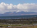
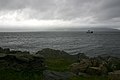
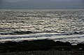
The Isle of Arran or Arran is the largest island in the Firth of Clyde, Scotland. There are two traditions concerning the geographic relationshp of the islands in the Firth of Clyde to the other western islands. One is that they are in the Inner Hebrides. A second is that the Hebrides extend only as far south as the Kintyre Peninsula, exclusive. For the arguments see the articles.
île britannique   | |||||
| Téléverser des médias | |||||
| Nature de l’élément | |||||
|---|---|---|---|---|---|
| Partie de | |||||
| Lieu | North Ayrshire, Écosse | ||||
| Baigné par | |||||
| Capitale | |||||
| Point culminant | |||||
| Population |
| ||||
| Superficie |
| ||||
| Altitude |
| ||||
| À ne pas confondre avec | |||||
 | |||||
Sous-catégories
Cette catégorie comprend 61 sous-catégories, dont les 61 ci-dessous.
- Beaches of the Isle of Arran (28 F)
*
A
- A841 road (Scotland) (24 F)
- Am Binnein, North Ayrshire (16 F)
- An Tunna (8 F)
- Arran Coastal Way (20 F)
- Arran hydro-electric schemes (6 F)
B
- Balliekine (12 F)
- Balmichael (7 F)
- Beinn Bhreac, Catacol (8 F)
- Beinn Tarsuinn, Catacol (3 F)
- Beinn Tarsuinn, Loch Nuis (2 F)
- Bridgend, Isle of Arran (1 F)
C
- Catacol Bay (8 F)
D
- Drumadoon Bay (5 F)
E
- Eas Mor, Isle of Arran (4 F)
G
- Garbh Allt, Glenrosa (10 F)
- Garbh Allt, Tarnacraig (7 F)
- Giants' Graves, Isle of Arran (19 F)
- Gleann Easbuig (15 F)
- Glen Chalmadale (6 F)
- Glen Iorsa (15 F)
I
- Imachar Point (1 F)
- Loch Iorsa (6 F)
- Iorsa Water (6 F)
K
- Kilbride, Isle of Arran (6 F)
- Kingscross Point (5 F)
M
- Meallach's Grave (4 F)
- Muileann Gaoithe (11 F)
N
S
- Sail Chalmadale (15 F)
- Stacach (4 F)
T
- The Bowman's Pass (3 F)
- Torr a'Chaisteal Fort (3 F)
- Torrylin Cairn (8 F)
Pages dans la catégorie « Isle of Arran »
Cette catégorie comprend seulement la page ci-dessous.
Média dans la catégorie « Isle of Arran »
Cette catégorie comprend 244 fichiers, dont les 200 ci-dessous.
(page précédente) (page suivante)-
 "Pirates Cove" Arran - geograph.org.uk - 35974.jpg 640 × 480 ; 113 kio
-
 Allt a Bhuic Meets the Sea. - geograph.org.uk - 348312.jpg 640 × 480 ; 106 kio
-
 An Cumhann - Isle of Arran - geograph.org.uk - 6179059.jpg 4 365 × 3 300 ; 5,49 Mio
-
 Ardrossan shore - geograph.org.uk - 177563.jpg 640 × 480 ; 70 kio
-
 ARR.1a-000034 Arran Machrie Moor.jpg 455 × 300 ; 144 kio
-
 Arran @ New Years Eve 31.12.2009 - panoramio.jpg 2 995 × 1 246 ; 3,16 Mio
-
 Arran across Kilbrannan Sound from B842 - geograph.org.uk - 2139776.jpg 1 024 × 768 ; 146 kio
-
 Arran and Bute - geograph.org.uk - 890585.jpg 640 × 341 ; 58 kio
-
 Arran and the ferry from Claonaig.jpg 640 × 435 ; 57 kio
-
 Arran camping.jpg 1 632 × 1 224 ; 194 kio
-
 Arran from ferry - panoramio.jpg 1 280 × 960 ; 825 kio
-
 Arran from Lunderston Bay - geograph.org.uk - 4058623.jpg 640 × 387 ; 106 kio
-
 Arran from Port Righ. - geograph.org.uk - 248693.jpg 640 × 162 ; 35 kio
-
 Arran from South Eilean, Millport bay (149246826).jpg 2 048 × 1 536 ; 649 kio
-
 Arran Heritage Museum, Rosaburn - geograph.org.uk - 1066712.jpg 640 × 433 ; 98 kio
-
 Arran highland games 2007 - geograph.org.uk - 945512.jpg 640 × 480 ; 77 kio
-
 Arran highland games 2007 - geograph.org.uk - 945522.jpg 640 × 480 ; 110 kio
-
 Arran Overview.jpg 800 × 137 ; 20 kio
-
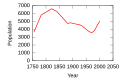 Arran population.svg 600 × 400 ; 6 kio
-
 Arran shore - geograph.org.uk - 214303.jpg 640 × 480 ; 98 kio
-
 Arran Summer Sunset 2 - panoramio.jpg 1 280 × 960 ; 438 kio
-
 Arran sunset.jpg 4 078 × 2 039 ; 2,62 Mio
-
 Arran View - geograph.org.uk - 2857626.jpg 640 × 413 ; 114 kio
-
 Arran Yacht Club - geograph.org.uk - 1375141.jpg 640 × 480 ; 64 kio
-
 Arran, 1967.jpg 534 × 749 ; 432 kio
-
 Arran-06-Faehre-2009-gje.jpg 3 072 × 2 048 ; 1,83 Mio
-
 Arran-08-Steine am Meer-2009-gje.jpg 3 060 × 1 810 ; 2,07 Mio
-
 Arran-10-Steine am Meer-2009-gje.jpg 3 003 × 1 722 ; 1,79 Mio
-
 Arran-12-Steine am Meer-2009-gje.jpg 2 970 × 1 842 ; 1,39 Mio
-
 Arran-14-Meeresleuchten-2009-gje.jpg 3 072 × 1 888 ; 1,66 Mio
-
 Arran-16-Meeresleuchten-2009-gje.jpg 3 016 × 1 950 ; 2,14 Mio
-
 Arran-22-Shiskine-Godfreys Vogelhaus-2009-gje.jpg 2 631 × 1 704 ; 1,73 Mio
-
 Arran-24-Landschaft-2009-gje.jpg 3 057 × 1 848 ; 1,95 Mio
-
 Arran-26-Landschaft-2009-gje.jpg 3 072 × 1 797 ; 2,35 Mio
-
 Arran-28-Passhoehe Shiskine-Brodick-2009-gje.jpg 3 072 × 1 965 ; 2,11 Mio
-
 ArranBlonde.jpg 589 × 1 024 ; 168 kio
-
 B842 near Grogport, Kintyre. - geograph.org.uk - 103848.jpg 640 × 480 ; 62 kio
-
 Beach at Torrylinnwater Foot - geograph.org.uk - 1288630.jpg 640 × 480 ; 141 kio
-
 Bende wim31.jpg 3 044 × 2 043 ; 683 kio
-
 Bluebells at Dippin - geograph.org.uk - 445312.jpg 640 × 480 ; 76 kio
-
-
 Brodick Bay, Goatfell and a steamer. 1841.jpg 3 704 × 2 167 ; 2,05 Mio
-
 Brodick Castle quay view.jpg 3 888 × 2 592 ; 2,36 Mio
-
 Burn in Gleann Easan Biorach, Arran - geograph.org.uk - 865239.jpg 640 × 419 ; 80 kio
-
 Bute and Arran from Largs - geograph.org.uk - 6149357.jpg 1 024 × 535 ; 83 kio
-
 Carradale Harbour - geograph.org.uk - 24015.jpg 640 × 480 ; 52 kio
-
 Cask lid Arran Lochranza distillery.jpg 1 714 × 1 834 ; 1,05 Mio
-
 Chapelton Shore and South Inch, Seamill, North Ayrshire. Isle of Arran.jpg 4 875 × 2 274 ; 1,89 Mio
-
 Cir Mhor summit rocks (geograph 5663690).jpg 1 280 × 878 ; 415 kio
-
 Cir Mhòr - Flickr - Graham Grinner Lewis.jpg 4 000 × 3 000 ; 2,53 Mio
-
 Clach a' Chash (Cat Stone) Arran - geograph.org.uk - 35979.jpg 640 × 480 ; 108 kio
-
 Clearances plaque.jpg 3 648 × 2 736 ; 3,85 Mio
-
 Cleats shore near low tide - geograph.org.uk - 1373999.jpg 640 × 443 ; 69 kio
-
 Cleiteadh buidhe, Machrie, Arran - geograph.org.uk - 1051516.jpg 640 × 480 ; 101 kio
-
 Cleiteadh Mòr - geograph.org.uk - 3301824.jpg 5 184 × 3 456 ; 7,08 Mio
-
 Cleits at Cleats Shore - geograph.org.uk - 1373659.jpg 640 × 458 ; 80 kio
-
 Cloud formation (25356005208).jpg 4 608 × 3 072 ; 4,69 Mio
-
 Clyde Estuary outbound.jpg 3 072 × 2 048 ; 1,04 Mio
-
 Coastline below Torran Riabhach - geograph.org.uk - 3271333.jpg 3 872 × 2 592 ; 2,62 Mio
-
 Coastline south of Corrie - geograph.org.uk - 5944739.jpg 4 000 × 3 000 ; 6,35 Mio
-
 Coire Fhionn Lochan, East End of Lochan - geograph.org.uk - 53520.jpg 640 × 480 ; 140 kio
-
 Cormorants south of Sannox - geograph.org.uk - 3061702.jpg 640 × 480 ; 96 kio
-
 Corrie Harbour, Arran - geograph.org.uk - 1048538.jpg 640 × 480 ; 104 kio
-
 Corrie Hotel.jpg 3 872 × 2 592 ; 4,12 Mio
-
 Cranhill Secondary School Arran trip, 1967 - Flickr - PhillipC (1).jpg 1 626 × 1 026 ; 562 kio
-
 Cranhill Secondary School Arran trip, 1967 - Flickr - PhillipC.jpg 1 598 × 997 ; 707 kio
-
 Cranhill students, Arran, Scotland, 1967 - Flickr - PhillipC (1).jpg 2 127 × 1 447 ; 1,71 Mio
-
 Cranhill students, Arran, Scotland, 1967 - Flickr - PhillipC.jpg 2 100 × 1 424 ; 2,52 Mio
-
 Cruise ship The World - geograph.org.uk - 58056.jpg 640 × 480 ; 102 kio
-
 Day 1, Brodick Castle (5456136203).jpg 4 928 × 3 264 ; 1,66 Mio
-
 Day trip to Arran (46727000725).jpg 4 608 × 3 456 ; 4,22 Mio
-
 Day trip to Arran (47589861962).jpg 4 608 × 3 456 ; 4,28 Mio
-
 Day trip to Arran (47642625971).jpg 4 608 × 3 456 ; 3,78 Mio
-
 Dippen Head - geograph.org.uk - 2803988.jpg 4 320 × 3 240 ; 4,73 Mio
-

-
 Dougarie - geograph.org.uk - 3068424.jpg 479 × 640 ; 85 kio
-
 Down To The Little Loch - panoramio.jpg 2 916 × 1 944 ; 3,37 Mio
-
 Dreghorn from war memorial.jpg 3 059 × 2 294 ; 1,8 Mio
-
 Dunrod Hill - geograph.org.uk - 448175.jpg 640 × 480 ; 84 kio
-
 Ecosse-été 2012 331.jpg 4 608 × 3 456 ; 5,36 Mio
-
 Edward Gennys Fanshawe, Arran and the Firth of Clyde from Fairlie, 1843 (Scotland).jpg 1 280 × 947 ; 1,07 Mio
-
 Facing south west from Toward Point - geograph.org.uk - 82901.jpg 640 × 480 ; 117 kio
-
 Fairy Dell - geograph.org.uk - 2972575.jpg 3 456 × 4 608 ; 5,59 Mio
-
 Fence on the entrance to Kings Cove - geograph.org.uk - 2075386.jpg 3 414 × 2 663 ; 1,45 Mio
-
Ferry Arran Ardrossan.ogv 32 s, 960 × 540 ; 2,14 Mio
-
 Ferry from Arran to Kintyre (9860389426).jpg 3 264 × 2 448 ; 1,2 Mio
-
 Firth of Clyde and Arran from Ayrshire Coastal Path, Dunure, South Ayrshire.jpg 4 896 × 2 752 ; 3,34 Mio
-
 Fish Trap area and the Arran Ferry, Ardrossan North beach, North Ayrshire.jpg 4 267 × 2 370 ; 1,9 Mio
-
 Fisherman's walk on Arran (32702955187).jpg 4 608 × 3 072 ; 4,01 Mio
-
 Fisherman's walk on Arran (32702957887).jpg 4 608 × 3 072 ; 3,93 Mio
-
 Fisherman's walk on Arran (46729774685).jpg 4 608 × 3 072 ; 4,19 Mio
-
 Fisherman's walk on Arran (46729796795).jpg 4 608 × 3 072 ; 5,94 Mio
-
 Fisherman's walk on Arran (46921408464).jpg 4 608 × 3 072 ; 4 Mio
-
 Fisherman's walk on Arran (46921411854).jpg 4 608 × 3 072 ; 4,29 Mio
-
 Fisherman's walk on Arran (47592562752).jpg 4 608 × 3 072 ; 7,98 Mio
-
 Fisherman's walk on Arran (47592574292).jpg 4 608 × 3 072 ; 6,03 Mio
-
 Fisherman's walk on Arran (47645470971).jpg 4 608 × 3 072 ; 5,82 Mio
-
 Fisherman's walk on Arran (47645485971).jpg 4 493 × 3 060 ; 4,26 Mio
-
 Fisherman's walk on Arran (47645487201).jpg 4 608 × 3 072 ; 4,86 Mio
-
 Fisherman's walk on Arran (47645487911).jpg 4 608 × 3 072 ; 4,67 Mio
-
 Fishermans Walk on Arran (32703016357).jpg 4 608 × 3 072 ; 5,11 Mio
-
 Fishermans Walk on Arran (32703021907).jpg 4 608 × 3 072 ; 5,35 Mio
-
 Fishermans Walk on Arran (46921496684).jpg 4 608 × 3 072 ; 4,44 Mio
-
 Fishermans Walk on Arran (46921497934).jpg 4 608 × 3 072 ; 4,49 Mio
-
 Foreshore at South Inch - geograph.org.uk - 4335020.jpg 800 × 600 ; 98 kio
-
 Garbh Choire - geograph.org.uk - 1453928.jpg 640 × 428 ; 60 kio
-
 Giants Grave (24337812577).jpg 4 134 × 2 797 ; 2,91 Mio
-
 Giants Grave (38322507165).jpg 4 298 × 2 935 ; 2,67 Mio
-
 Giants Grave (39198841371).jpg 4 201 × 3 049 ; 4,16 Mio
-
 Gleann Easan Biorach, Arran - geograph.org.uk - 865235.jpg 640 × 432 ; 104 kio
-
 Glen Rosa - geograph.org.uk - 1036047.jpg 640 × 428 ; 29 kio
-
 Glen Scaftigill - geograph.org.uk - 3210192.jpg 4 608 × 3 456 ; 5,55 Mio
-
 Glenashdale Falls.jpg 106 × 320 ; 39 kio
-
 Gormley Land Saddel Bay Arran.jpg 4 000 × 3 000 ; 4,42 Mio
-
 Granite Mountains - geograph.org.uk - 2358361.jpg 800 × 531 ; 127 kio
-

-
 Hans Gude--Gudstjeneste ved Arran--1877.jpg 2 611 × 1 248 ; 864 kio
-
 Heather from the hills, Arran (1864), by Robert Herdman.jpg 2 048 × 2 734 ; 1,24 Mio
-
 Holy Isle from the Caledonian Isles - geograph.org.uk - 2575319.jpg 640 × 480 ; 36 kio
-
 Horse Isle and Arran from Montfode, Ardrossan, North Ayrshire.jpg 4 896 × 2 752 ; 2,96 Mio
-
 House and sheep, Isle of Arran (1981).JPG 2 533 × 1 662 ; 1,21 Mio
-
 House of Fraser - geograph.org.uk - 1061783.jpg 640 × 480 ; 104 kio
-
 Hut circle, Torr Righ.jpg 3 888 × 2 592 ; 4,58 Mio
-
 Igneous (dolerite) compound dyke - geograph.org.uk - 44623.jpg 480 × 640 ; 115 kio
-
 Inner lighthouse, Holy Isle.JPG 3 648 × 2 736 ; 5,48 Mio
-
 Irvine from Dreghorn war memorial.jpg 3 264 × 2 448 ; 1,67 Mio
-
 Isle of Arran & Little Cumbrae from Fairlie, 1841.jpg 3 755 × 2 130 ; 1,78 Mio
-
 Isle of Arran - panoramio.jpg 2 576 × 1 932 ; 1,1 Mio
-
 Isle of Arran 2.jpg 640 × 421 ; 88 kio
-
 Isle of Arran and Glenfoot House - geograph.org.uk - 1086144.jpg 640 × 428 ; 71 kio
-
 Isle of Arran Rocks - geograph.org.uk - 1043208.jpg 640 × 480 ; 58 kio
-
 Isle of Arran, April, 2017-10.jpg 5 145 × 3 423 ; 8,82 Mio
-
 Isle of Arran, April, 2017-11.jpg 4 885 × 3 256 ; 5,41 Mio
-
 Isle of Arran, April, 2017-2.jpg 5 116 × 3 410 ; 6,8 Mio
-
 Isle of Arran, April, 2017-3.jpg 4 833 × 3 222 ; 6,71 Mio
-
 Isle of Arran, April, 2017-4.jpg 5 007 × 3 338 ; 7,25 Mio
-
 Isle of Arran, April, 2017-5.jpg 5 069 × 3 380 ; 5,74 Mio
-
 Isle of Arran, April, 2017-6.jpg 4 890 × 3 260 ; 6,54 Mio
-
 Isle of Arran, April, 2017-8.jpg 5 126 × 3 417 ; 6,44 Mio
-
 Isle of Arran, April, 2017-9.jpg 4 973 × 3 315 ; 7,98 Mio
-
 Isle of Arran.jpg 300 × 225 ; 12 kio
-
 Jenn Butterworth Playing Guitar on Stage.jpg 1 080 × 720 ; 93 kio
-
 Kaim Hill 2 ascent beside Fairlie Glen.jpg 3 072 × 2 304 ; 1,91 Mio
-
 Kaim Hill 3 Firlie Glen and Arran.jpg 3 072 × 2 304 ; 1,56 Mio
-
 Kaim Hill 7 view from summit.jpg 3 064 × 2 298 ; 1,79 Mio
-
 Kilbrannan Sound with Arran in the background. - geograph.org.uk - 86271.jpg 640 × 480 ; 115 kio
-
 Kildonan (38227722665).jpg 4 563 × 3 044 ; 1,58 Mio
-
 Kildonan, Pladda & Ailsa Craig from the air.jpg 640 × 424 ; 52 kio
-
 Kings cave (27331945599).jpg 4 608 × 3 072 ; 5,7 Mio
-
 Kings caves (38399034074).jpg 4 608 × 3 072 ; 4,57 Mio
-
 Kings Caves (38700480984).jpg 2 520 × 3 776 ; 4,38 Mio
-
 Kings caves (39109221521).jpg 4 608 × 3 072 ; 1,52 Mio
-
 Lamlash Bay from the Dun, Kingscross Point - geograph.org.uk - 93019.jpg 640 × 480 ; 114 kio
-
 Light at the end of the Cave - geograph.org.uk - 2073639.jpg 3 648 × 2 736 ; 2,45 Mio
-
 Looking out to Arran from Portencross.jpg 1 280 × 720 ; 97 kio
-
 Looking to Drumadoon - geograph.org.uk - 2359254.jpg 800 × 531 ; 103 kio
-
 Looking towards Arran - geograph.org.uk - 1807142.jpg 1 739 × 1 175 ; 427 kio
-
 Low Tide on Ayr Beach - geograph.org.uk - 1007302.jpg 640 × 428 ; 40 kio
-
 Lower reaches of Gleann an t-Suidhe - geograph.org.uk - 77406.jpg 640 × 480 ; 107 kio
-
 Marida Mistletoe (chemical tanker).jpg 3 697 × 1 473 ; 1,08 Mio
-
 Maybole pipe band - geograph.org.uk - 945518.jpg 640 × 480 ; 85 kio
-
 Mile Stone at Glenloig - geograph.org.uk - 178805.jpg 425 × 640 ; 125 kio
-
 Mooring posts at Sannox jetty - geograph.org.uk - 811482.jpg 640 × 402 ; 60 kio
-

-
 Mum and dad on Arran (157411087).jpg 1 024 × 768 ; 290 kio
-
 Near The Cock Of Arran - geograph.org.uk - 2742701.jpg 2 560 × 1 706 ; 933 kio
-
 North end of Ailsa Craig.jpg 640 × 480 ; 64 kio
-
 North-West Arran View - geograph.org.uk - 5562106.jpg 640 × 365 ; 67 kio
-
 Paddleship Waverley passing Arran - panoramio.jpg 1 280 × 960 ; 858 kio
-
 Pladaighadeas.jpg 640 × 426 ; 92 kio
-
 Port a'Mhuilleir, Arran - geograph.org.uk - 812083.jpg 640 × 424 ; 73 kio
-
 Post Box - geograph.org.uk - 41850.jpg 640 × 480 ; 57 kio
-
 Rinn a Chrubain - geograph.org.uk - 2975457.jpg 4 608 × 3 456 ; 4,91 Mio
-

-
 Rubha Airigh Bheirg - geograph.org.uk - 2964172.jpg 3 456 × 4 608 ; 5,7 Mio
-
 Rubha Salach - geograph.org.uk - 814395.jpg 640 × 427 ; 90 kio
-
 Ruined farm, Arran (5457359100).jpg 4 928 × 3 264 ; 2,49 Mio
-

-
 Scotland, Isle of Arran, World War I Memorial.JPG 2 112 × 1 388 ; 1,31 Mio
-
Sea Arran1.ogv 15 s, 960 × 540 ; 13,49 Mio
-
 Sea texture scotland.jpg 3 008 × 2 000 ; 1,57 Mio
-
 Seamill Beach and the Isle of Arran, North Ayrshire.jpg 4 503 × 2 075 ; 2,31 Mio
-
 Seamill, Firth of Clyde.jpg 1 812 × 1 277 ; 205 kio
-
 Shore between Bennan Head and Kildonan Beach - geograph.org.uk - 2959780.jpg 3 456 × 4 608 ; 5,52 Mio
-
 Skervuile Lighthouse - geograph.org.uk - 763615.jpg 640 × 299 ; 24 kio
-
 Slanted Ironstone - geograph.org.uk - 1994528.jpg 800 × 600 ; 157 kio
-
 Slope dropping to north Arran coast - geograph.org.uk - 2881548.jpg 1 500 × 1 125 ; 1,43 Mio
-
 Spring Morning View of Beinn Nuis and Beinn Tarsuinn.JPG 6 627 × 2 279 ; 2,79 Mio
-
 Standing stones , Machrie Moor (24278136327).jpg 4 464 × 3 072 ; 3,28 Mio
-
 Standing stones , Machrie Moor (24278150667).jpg 4 086 × 2 578 ; 2,59 Mio
-
 Standing stones , Machrie Moor (27360106509).jpg 4 332 × 3 031 ; 2,26 Mio
-
 Standing stones , Machrie Moor (38428176594).jpg 4 493 × 2 901 ; 2,78 Mio
-
 Standing stones , Machrie Moor (39106561512).jpg 4 556 × 3 072 ; 2,92 Mio
-
 Standing stones , Machrie Moor (39138011591).jpg 4 327 × 2 792 ; 2,65 Mio
-
 Stones , King's Caves (27446143459).jpg 4 608 × 3 072 ; 4,58 Mio
-
 Strathwhillan, Arran - geograph.org.uk - 1044134.jpg 640 × 480 ; 99 kio
-
 Strathwhillan, Arran - geograph.org.uk - 1052993.jpg 640 × 480 ; 126 kio
-
 String Road summit - geograph.org.uk - 1171028.jpg 640 × 428 ; 40 kio
-
 Sunset over Arran (3424914066).jpg 1 448 × 982 ; 281 kio
-
 Sunset over Arran from Ardrossan Harbour - geograph.org.uk - 9279.jpg 640 × 427 ; 108 kio


.jpg)


.jpg)

_Arran_-_geograph.org.uk_-_35979.jpg)


.jpg)


.jpg)

.jpg)


.jpg)
.jpg)
.jpg)
.jpg)


.jpg)


.jpg)


.jpg)
.jpg)
.jpg)
.jpg)
.jpg)
.jpg)
.jpg)
.jpg)
.jpg)
.jpg)
.jpg)
.jpg)
.jpg)
.jpg)
.jpg)
.jpg)


.jpg)
.jpg)
.jpg)


,_by_Robert_Herdman.jpg)


.JPG)


_compound_dyke_-_geograph.org.uk_-_44623.jpg)


.jpg)

.jpg)
.jpg)
.jpg)
.jpg)


.jpg)


_-_Evening_Thoughts_-_NG_2136_-_National_Galleries_of_Scotland.jpg)


.jpg)


.jpg)
.jpg)
.jpg)
.jpg)
.jpg)
.jpg)
.jpg)


.jpg)

.jpg)