Category:Lantabat
Aller à la navigation
Aller à la recherche
English: Lantabat or Landibarre is a municipality in the Basque province of Lower Navarre and administratively part of Pyrénées-Atlantiques department.
Euskara: Landibarre Nafarroa Behereko udalerri bat da. Administratiboki Pirinio Atlantikoak departamenduan dago.
commune française du département des Pyrénées-Atlantiques _church_St.Martin_sideview.JPG)  | |||||
| Téléverser des médias | |||||
| Nature de l’élément | |||||
|---|---|---|---|---|---|
| Lieu |
| ||||
| Population |
| ||||
| Superficie |
| ||||
| Altitude |
| ||||
 | |||||
Sous-catégories
Cette catégorie comprend 11 sous-catégories, dont les 11 ci-dessous.
B
- Basque steles in Lantabat (6 F)
C
L
- Lantabat Ascombéguy (5 F)
- Lantabat Béhaune (2 F)
- Lantabat Luisenialdea (1 F)
M
- Maps of Lantabat (3 F)
T
- Town hall of Lantabat (1 F)
Média dans la catégorie « Lantabat »
Cette catégorie comprend 14 fichiers, dont les 14 ci-dessous.
-
 64313-Lantabat-Routes-Hydro.png 3 507 × 2 480 ; 2,42 Mio
-
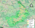 64313-Lantabat-Sols.png 3 270 × 2 598 ; 2,39 Mio
-
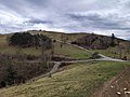 Col des Palombieres.jpg 4 640 × 3 472 ; 8,77 Mio
-
 Ferme Elizeria Saint-Martin.jpg 4 640 × 3 472 ; 10,06 Mio
-
 Landibarre kokapena.png 297 × 385 ; 76 kio
-
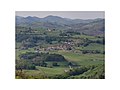 Lantabar depuis Ipharlatze.jpg 4 000 × 3 000 ; 1,47 Mio
-
 Lantabat (Pyr-Atl, Fr) Mariage en tradition Basque, chariot de la mariée.JPG 4 000 × 3 000 ; 4,02 Mio
-
 Lantabat (Pyr-Atl, Fr) Mariage en tradition Basque, la mariée vient en chariot.JPG 4 000 × 3 000 ; 4,32 Mio
-

-
 Le village de Behaune, au Pays Basque, vers Lantabat - panoramio.jpg 3 066 × 1 631 ; 1,24 Mio
-
 Maison forte Donosteia Saint-Martin Lantabat.jpg 4 640 × 3 472 ; 7,67 Mio
-
 Maison forte Elizeria à Saint-Martin.jpg 4 640 × 3 472 ; 10,02 Mio
-
 Map commune FR insee code 64313.png 756 × 605 ; 61 kio
-
 Population - Municipality code 64313.svg 475 × 355 ; 13 kio


_Mariage_en_tradition_Basque,_chariot_de_la_mari%C3%A9e.JPG)
_Mariage_en_tradition_Basque,_la_mari%C3%A9e_vient_en_chariot.JPG)
_Mariage_en_tradition_basque,_le_chariot_de_la_mari%C3%A9e_avec_des_bottes_de_lin..JPG)


