Category:Louisiade Archipelago
Aller à la navigation
Aller à la recherche
English: The Louisiade Archipelago — in Milne Bay Province of Papua New Guinea.
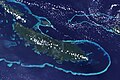
- A string of ten larger volcanic islands frequently fringed by coral reefs, and 90 smaller coral islands located 200 km southeast of New Guinea, stretching over more than 160 kilometres (99 mi) and spread over an ocean area of 26,000 square kilometres (10,000 sq mi) between the Solomon Sea to the north and the Coral Sea to the south.
- The tropical Louisiade Archipelago rain forests are in the Tropical and subtropical moist broadleaf forests ecoregion.
archipelago of Papua New Guinea  | |||||
| Téléverser des médias | |||||
| Nature de l’élément | |||||
|---|---|---|---|---|---|
| Lieu | Baie de Milne, PNG | ||||
| Baigné par | |||||
| Superficie |
| ||||
 | |||||
Sous-catégories
Cette catégorie comprend 2 sous-catégories, dont les 2 ci-dessous.
D
R
- Rossel Island (4 F)
Média dans la catégorie « Louisiade Archipelago »
Cette catégorie comprend 36 fichiers, dont les 36 ci-dessous.
-

-

-
 Anagusa (Landsat).JPG 304 × 215 ; 12 kio
-
 Bonvouloir Islands (Landsat).jpg 1 265 × 1 035 ; 270 kio
-
 Calvados Chain (Landsat).JPG 3 220 × 800 ; 457 kio
-
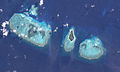
 Conflict Group.jpg 883 × 548 ; 289 kio
-
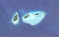
 Deboyne Islands (Landsat).jpg 508 × 348 ; 35 kio
-
 Diary of the Voyage of HMS Rattlesnakeed, Thomas Henry Huxley, 1935 - Image 206179.jpg 2 560 × 1 920 ; 1,98 Mio
-
 Duchateau Islands (Landsat).JPG 338 × 211 ; 15 kio
-
 FMIB 53002 Louisiade Archipelago.jpeg 700 × 432 ; 58 kio
-
 Jomard Islands (Landsat).JPG 358 × 225 ; 16 kio
-
 Karta PG Louisiade isl.PNG 300 × 200 ; 4 kio
-
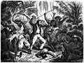
 Le Tour du monde-04-p081.jpg 565 × 424 ; 76 kio
-
 Le Tour du monde-04-p085.jpg 2 552 × 1 920 ; 1,24 Mio
-
 Le Tour du monde-04-p088.jpg 2 519 × 1 903 ; 1 002 kio
-
 Le Tour du monde-04-p089.jpg 3 773 × 2 524 ; 1,85 Mio
-
 Le Tour du monde-04-p092.jpg 2 536 × 1 887 ; 1,13 Mio
-
 Le Tour du monde-04-p093.jpg 2 491 × 3 729 ; 2,06 Mio
-
 Louisiade Archipelago 1922 nautical chart.jpg 8 070 × 5 638 ; 6,07 Mio
-
 Louisiade Archipelago 1942 map.jpg 12 124 × 6 215 ; 47 Mio
-
 Louisiade Archipelago Banner.JPG 4 320 × 617 ; 610 kio
-
 Louisiade archipelago.jpg 2 000 × 1 500 ; 449 kio
-
 Louisiade banner.jpg 4 320 × 617 ; 729 kio
-
 Louisiadearchipelago.JPG 4 320 × 3 240 ; 3,35 Mio
-
 Misima Island.jpg 792 × 275 ; 66 kio
-
 Pana Tinani (Landsat).JPG 713 × 499 ; 82 kio
-
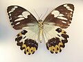 Papilio euchenor sudestensis Rothschild, 1808.JPG 3 072 × 2 304 ; 2,48 Mio
-
 Quessant (Landsat).JPG 399 × 239 ; 21 kio
-
 Rossel Island (Landsat).JPG 1 291 × 691 ; 242 kio
-
 Sloss Islets (Landsat).JPG 328 × 198 ; 19 kio
-
 Strathord Islands (Landsat).jpg 226 × 212 ; 15 kio
-
 Torlesse Islands (Landsat).jpg 363 × 188 ; 14 kio
-
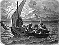
 Trading with the natives at Coral Haven, June 1849 - Image 206195.jpg 1 400 × 1 114 ; 192 kio
-
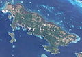
 Vanatinai, Louisiade Archipelago.jpg 3 600 × 2 400 ; 2,93 Mio
-
 Wari (Landsat).JPG 376 × 244 ; 26 kio
-
 Yeina (Landsat).JPG 743 × 449 ; 67 kio


.JPG)
.jpg)

.jpg)

.JPG)

.JPG)


.JPG)

.JPG)
.JPG)
.JPG)
.jpg)
.jpg)


.JPG)
.JPG)
.JPG)