Category:Lymm
Zur Navigation springen
Zur Suche springen
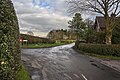
Български: 300px|мини|Изглед от центъра на Лим
Deutsch: Lymm ist eine Gemeinde (civil parish) im Osten der englischen Unitary Authority Warrington in der Region North West England. Im Jahr 2001 zählte sie 10.552 Einwohner.
English: Lymm (pronounced "Lim") is a large village and civil parish in Warrington, Cheshire, in North West England. Lymm was an urban district of Cheshire from 1894 to 1974.
Nederlands: Lymm is een plaats in het bestuurlijke gebied Warrington, in het Engelse graafschap Cheshire. De plaats telt 10.522 inwoners.
village and civil parish in Cheshire, United Kingdom  | |||||
| Medium hochladen | |||||
| Ist ein(e) | |||||
|---|---|---|---|---|---|
| Ort | Borough of Warrington, Cheshire, North West England, England | ||||
 | |||||
Unterkategorien
Es werden 9 von insgesamt 9 Unterkategorien in dieser Kategorie angezeigt:
In Klammern die Anzahl der enthaltenen Kategorien (K), Seiten (S), Dateien (D)
B
C
L
- Lymm Cross (10 D)
- Lymm railway station (2 D)
- Lymm Services (15 D)
- Lymm War Memorial (1 D)
M
Medien in der Kategorie „Lymm“
Folgende 200 Dateien sind in dieser Kategorie, von 475 insgesamt.
(vorherige Seite) (nächste Seite)-
 "Milestone" on the Trans Pennine Trail near Heatley - geograph.org.uk - 3223914.jpg 3.508 × 2.579; 3,57 MB
-
 'Life for a Life' Lymm Memorial Forest - geograph.org.uk - 3294214.jpg 3.968 × 2.232; 5,12 MB
-
 'Life for a Life' Lymm Memorial Forest - geograph.org.uk - 3294222.jpg 3.968 × 2.232; 5,57 MB
-
 1 mile to J21, M6 - geograph.org.uk - 4506373.jpg 640 × 408; 35 KB
-
 10 Statham Avenue - geograph.org.uk - 4524391.jpg 1.000 × 750; 278 KB
-
 13, 15, 17 & 19 Church Road, Lymm.jpg 1.800 × 1.350; 639 KB
-
 1A and 3, Lymm Bridge.jpg 3.000 × 4.000; 4,31 MB
-
 2137 (Lymm) Squadron Badge.png 676 × 878; 324 KB
-
 47 bus Lymm Knutsford.jpg 2.164 × 1.432; 1,06 MB
-
 47 bus Warrington Lymm Knutsford.jpg 1.508 × 922; 451 KB
-
 5, 7, 9, 11 and 13, The Grove.jpg 3.319 × 2.477; 1,13 MB
-
 90, Warrington Road, Lymm.jpg 4.000 × 3.000; 5,11 MB
-
 A footpath at Burfordlane Farm - geograph.org.uk - 4433832.jpg 2.622 × 3.065; 5,06 MB
-
 A twisty Agden lane - geograph.org.uk - 3364040.jpg 640 × 480; 70 KB
-
 A50 overbridge, M6 - geograph.org.uk - 4506368.jpg 640 × 369; 28 KB
-
 A56 Booth's Hill Road - geograph.org.uk - 4811180.jpg 640 × 481; 61 KB
-
 A6144 - geograph.org.uk - 29228.jpg 640 × 480; 105 KB
-

-
 Aerial view from over Warrington - geograph.org.uk - 4509682.jpg 3.264 × 2.448; 4,2 MB
-

-
 B5158 Cherry Lane - geograph.org.uk - 2468876.jpg 3.959 × 2.509; 3,59 MB
-
 B5158, Cherry Lane - geograph.org.uk - 3521363.jpg 640 × 481; 233 KB
-
 Banks of the Ship Canal opposite Butchersfield, Lymm - geograph.org.uk - 3226547.jpg 3.573 × 2.644; 4,56 MB
-
 Barn at Heatley Farm - geograph.org.uk - 3116927.jpg 1.920 × 1.080; 619 KB
-
 Barn, Agdenlane Farm - geograph.org.uk - 3364038.jpg 640 × 480; 68 KB
-
 Barsbank Lane - geograph.org.uk - 3354366.jpg 640 × 480; 88 KB
-
 Beechwood House Lymm Entrance.jpg 2.012 × 1.516; 1,49 MB
-
 Bent Lane (A6144) - geograph.org.uk - 3354460.jpg 640 × 480; 74 KB
-
 Big Wood - geograph.org.uk - 49137.jpg 640 × 480; 97 KB
-
 Birch Brook Road (A6144) - geograph.org.uk - 3354390.jpg 640 × 480; 73 KB
-
 Birch Brook Road - geograph.org.uk - 1386593.jpg 640 × 480; 70 KB
-
 Blocked footpath - geograph.org.uk - 3968491.jpg 3.694 × 2.378; 4,08 MB
-
 Boat Stage in Lymm - geograph.org.uk - 3896056.jpg 1.024 × 695; 166 KB
-
 Bogus pine tree on the fringe of Lymm Golf Club - geograph.org.uk - 3223935.jpg 3.495 × 2.645; 2,92 MB
-
 Booth's Hill Farm - geograph.org.uk - 6101547.jpg 1.600 × 1.280; 482 KB
-
 Booth's Lane - geograph.org.uk - 6101544.jpg 1.600 × 1.200; 723 KB
-
 Bridge over Bridgewater Canal - geograph.org.uk - 4752828.jpg 3.264 × 2.448; 2,71 MB
-

-
 Bridgewater Canal south of Stage Lane - geograph.org.uk - 4752826.jpg 3.264 × 2.448; 2,28 MB
-
 Bridgewater Canal west of Agden Bridge - geograph.org.uk - 5397166.jpg 4.032 × 3.024; 2,77 MB
-
 Bridgewater Street Aqueduct, Lymm - geograph.org.uk - 4611945.jpg 1.200 × 900; 227 KB
-
 Bridgewater Street, Lymm.jpg 640 × 480; 438 KB
-
 Broomedge - Burford Lane - geograph.org.uk - 1337602.jpg 640 × 480; 198 KB
-
 Broomedge - Costcutter Local Store - geograph.org.uk - 1337604.jpg 640 × 480; 162 KB
-
 Broomedge - geograph.org.uk - 4262032.jpg 3.878 × 2.221; 1,49 MB
-
 Broomedge - The Drive - geograph.org.uk - 1337599.jpg 640 × 480; 161 KB
-
 Broomedge Nurseries - geograph.org.uk - 2862983.jpg 640 × 480; 500 KB
-
 Bucklow Gardens, Rushgreen - geograph.org.uk - 3354380.jpg 800 × 525; 76 KB
-
 Building new homes, Rushgreen - geograph.org.uk - 3354386.jpg 800 × 600; 100 KB
-
 Burford Lane (B5159) - geograph.org.uk - 2862981.jpg 640 × 480; 435 KB
-
 Burford Lane - geograph.org.uk - 2677252.jpg 640 × 480; 123 KB
-
 Burford Lane, Bridgewater Canal - geograph.org.uk - 3117398.jpg 1.920 × 1.080; 1,37 MB
-
 Canal at Lymm, Cheshire - geograph.org.uk - 5048272.jpg 5.472 × 3.648; 3,05 MB
-
 Cherry Lane (B5158) - geograph.org.uk - 3363941.jpg 640 × 480; 114 KB
-
 Cherry Lane (B5158) - geograph.org.uk - 3363949.jpg 1.200 × 900; 280 KB
-
 Cherry Lane (B5158) - geograph.org.uk - 3363962.jpg 640 × 480; 92 KB
-
 Cherry Lane (B5158) - geograph.org.uk - 3521360.jpg 640 × 481; 437 KB
-
 Cherry Lane (B5158) - geograph.org.uk - 3521369.jpg 640 × 480; 486 KB
-
 Cherry lane - geograph.org.uk - 1538957.jpg 640 × 405; 61 KB
-
 Cherry Lane - geograph.org.uk - 2468870.jpg 4.000 × 3.000; 4,47 MB
-
 Cherry Lane Barn - geograph.org.uk - 2862842.jpg 640 × 480; 356 KB
-
 Cherry Lane Farm - geograph.org.uk - 2862841.jpg 640 × 480; 396 KB
-
 Cherry Lane-Elm Tree Road junction - geograph.org.uk - 2677285.jpg 640 × 480; 67 KB
-
 Cheshire Flatlands - geograph.org.uk - 1337525.jpg 640 × 480; 184 KB
-
 Church Green - geograph.org.uk - 4611853.jpg 1.200 × 900; 184 KB
-
 Church Road looking north - geograph.org.uk - 2677278.jpg 640 × 480; 62 KB
-
 Cliff Lane (A50) - geograph.org.uk - 3363935.jpg 640 × 480; 61 KB
-
 Climbing the Thelwall Viaduct - geograph.org.uk - 4506375.jpg 640 × 426; 37 KB
-
 Climbing to Thelwall Viaduct - geograph.org.uk - 4441326.jpg 640 × 294; 26 KB
-
 Coach and Lorry park at Lymm Services - geograph.org.uk - 4755542.jpg 1.000 × 750; 505 KB
-
 Coaches and Lorries at Lymm Services - geograph.org.uk - 4507170.jpg 1.000 × 700; 439 KB
-
 Community Centre, Oughtrington, Lymm - geograph.org.uk - 3224236.jpg 3.736 × 2.767; 3,46 MB
-
 Cottages by Lymm Bridge - geograph.org.uk - 4612692.jpg 900 × 1.200; 278 KB
-
 Cottages in Statham, near Lymm - geograph.org.uk - 3223705.jpg 4.000 × 3.000; 3,7 MB
-
 Cottages near the centre of Lymm - geograph.org.uk - 3968481.jpg 4.000 × 2.666; 2,78 MB
-
 Crabtree Lane - geograph.org.uk - 1337588.jpg 640 × 480; 202 KB
-
 Crosfield Bridge - geograph.org.uk - 3521294.jpg 640 × 481; 312 KB
-
 Crosfield Bridge, Lymm - geograph.org.uk - 3289357.jpg 3.968 × 2.232; 5,35 MB
-
 Crosfield Bridge, Lymm Dam - geograph.org.uk - 3521254.jpg 640 × 481; 313 KB
-
 Crossfield Bridge - geograph.org.uk - 1127761.jpg 640 × 480; 408 KB
-
 Crouchley Hall Farm - geograph.org.uk - 3968496.jpg 4.000 × 2.666; 6,71 MB
-
 Crouchley Lane - geograph.org.uk - 3521141.jpg 640 × 480; 518 KB
-
 Crouchley Lane near Yewtree Farm - geograph.org.uk - 3521144.jpg 640 × 481; 551 KB
-
 Crouchley Lane, Deansgreen - geograph.org.uk - 3521150.jpg 640 × 481; 236 KB
-
 Cycle path, Heatley - geograph.org.uk - 5744809.jpg 3.821 × 2.715; 4,17 MB
-
 Deansgreen - geograph.org.uk - 4826228.jpg 4.592 × 3.056; 7,23 MB
-
 Distant view of Reddish House and farm - geograph.org.uk - 5744811.jpg 3.938 × 2.835; 3,34 MB
-
 Elizabeth II Postbox, Lymm Services - geograph.org.uk - 2176445.jpg 682 × 1.024; 102 KB
-
 Elmas Café Bar - geograph.org.uk - 3968484.jpg 3.860 × 2.448; 1,74 MB
-
 Entering Warrington on the A50 - geograph.org.uk - 2468852.jpg 3.518 × 2.108; 2,81 MB
-
 Entrance to Meadow View Fisheries - geograph.org.uk - 3226904.jpg 3.479 × 2.578; 3,24 MB
-
 Eroded sandstone at Lymm Dam - geograph.org.uk - 4611867.jpg 1.200 × 900; 265 KB
-
 Fallen tree at Lymm Dam - geograph.org.uk - 4918269.jpg 800 × 641; 186 KB
-
 Fallen tree with cormorants, Lymm Dam - geograph.org.uk - 4432065.jpg 3.082 × 2.055; 1,87 MB
-
 Fantastic Deals Available Now^ - geograph.org.uk - 1337533.jpg 640 × 480; 155 KB
-
 Farm sign in Statham, Cheshire - geograph.org.uk - 3223752.jpg 3.570 × 2.700; 3,68 MB
-
 Farm track heading North - geograph.org.uk - 3354369.jpg 640 × 480; 128 KB
-
 Farmers Arms Pub Sign - geograph.org.uk - 4383118.jpg 480 × 640; 261 KB
-
 Farmland and pylons off Spring Lane - geograph.org.uk - 3364047.jpg 640 × 480; 43 KB
-
 Farmland and tree - geograph.org.uk - 3354371.jpg 900 × 986; 348 KB
-
 Farmland near Lymm - geograph.org.uk - 3354376.jpg 640 × 480; 66 KB
-
 Farmland of Massey Brook Lane - geograph.org.uk - 3354360.jpg 640 × 480; 76 KB
-
 Farmland off Cherry Lane - geograph.org.uk - 3363956.jpg 640 × 480; 60 KB
-
 Farmland off Cliff Lane - geograph.org.uk - 3363934.jpg 640 × 480; 72 KB
-
 Farmland off Higher Lane - geograph.org.uk - 3363975.jpg 640 × 480; 56 KB
-
 Farmland off Statham Lane - geograph.org.uk - 3354373.jpg 1.200 × 900; 282 KB
-
 Farmland off Wet Gate Lane - geograph.org.uk - 3364051.jpg 640 × 480; 54 KB
-
 Farmland, Cherry Hall Farm - geograph.org.uk - 3363944.jpg 640 × 480; 55 KB
-
 Farmland, Heatley - geograph.org.uk - 3354456.jpg 640 × 499; 79 KB
-
 Farmland, New Farm - geograph.org.uk - 3354377.jpg 640 × 480; 116 KB
-
 Farmland, Oxheys Farm - geograph.org.uk - 3363940.jpg 800 × 613; 91 KB
-
 Field of Poppies at Oxheys Farm - geograph.org.uk - 2468859.jpg 4.000 × 3.000; 4,72 MB
-
 Fields with track towards Lymm village - geograph.org.uk - 3226550.jpg 3.788 × 2.841; 3,38 MB
-
 Fishing Jetties, Lymm Dam - geograph.org.uk - 5716206.jpg 4.862 × 3.347; 3,23 MB
-
 Footbridge over Sow Brook to Lymm Golf Club - geograph.org.uk - 3226891.jpg 3.955 × 2.966; 5,49 MB
-
 Footbridge over Trans Pennine Trail, Lymm - geograph.org.uk - 3227385.jpg 3.883 × 2.912; 4,56 MB
-
 Footbridge to Spud Wood - geograph.org.uk - 4431699.jpg 4.427 × 2.073; 7,25 MB
-
 Footbridge to Spud Wood - geograph.org.uk - 4431824.jpg 4.592 × 2.432; 6,15 MB
-
 Footbridge, Slitten Brook, Lymm - geograph.org.uk - 3294253.jpg 3.968 × 2.232; 5,28 MB
-
 Footpath across Lymm Golf Club - geograph.org.uk - 3226894.jpg 3.869 × 2.902; 6 MB
-

-
 Footpath from Statham to Bridgewater canal - geograph.org.uk - 3227361.jpg 4.000 × 3.000; 5 MB
-
 Footpath North of Booths Lane - geograph.org.uk - 6101423.jpg 1.200 × 1.600; 607 KB
-
 Footpath off Burford Lane - geograph.org.uk - 3968509.jpg 3.712 × 2.396; 1,16 MB
-
 Footpath off Massey Brook Lane - geograph.org.uk - 3354357.jpg 640 × 480; 98 KB
-
 Footpath sign in field corner, Lymm FP33 - geograph.org.uk - 4612768.jpg 900 × 1.200; 284 KB
-
 Footpath through Helsdale Wood - geograph.org.uk - 4612726.jpg 1.200 × 900; 332 KB
-
 Footpath to Helsdale Wood - geograph.org.uk - 4612750.jpg 1.200 × 900; 375 KB
-
 Footpath towards Kay Lane - geograph.org.uk - 3363985.jpg 640 × 480; 73 KB
-
 Footpaths on the M V Trail, Booths Hill - geograph.org.uk - 6101434.jpg 1.600 × 1.200; 717 KB
-
 Former pub (Farmer's Arms) now an Italian Restaurant - geograph.org.uk - 3223267.jpg 6.000 × 4.000; 6,45 MB
-
 Four Lanes Meet - geograph.org.uk - 1337585.jpg 640 × 480; 151 KB
-
 From St. Peter's churchyard - geograph.org.uk - 4418035.jpg 1.024 × 680; 528 KB
-
 Gantry in middle of Thelwall Viaduct - geograph.org.uk - 4441328.jpg 640 × 320; 35 KB
-
 Gate and Path off Birch Brook Road - geograph.org.uk - 4383129.jpg 640 × 480; 317 KB
-
 Gate to track giving access to Manchester Ship Canal - geograph.org.uk - 3223647.jpg 4.000 × 3.000; 5,9 MB
-
 Gates to Field House - geograph.org.uk - 3363990.jpg 640 × 480; 123 KB
-
 Glasshouses off Cherry Lane - geograph.org.uk - 3363947.jpg 1.024 × 676; 114 KB
-
 Government plaque at Meadow View Fisheries - geograph.org.uk - 3227314.jpg 3.321 × 2.417; 2,56 MB
-
 Graffitied tree at Lymm Dam - geograph.org.uk - 4611874.jpg 1.200 × 900; 374 KB
-
 Grassland Off Bradshaw Lane - geograph.org.uk - 1337668.jpg 640 × 480; 194 KB
-
 Grazing off Stockport Road - geograph.org.uk - 3354350.jpg 640 × 480; 67 KB
-
 Grazing, Broomedge - geograph.org.uk - 3363984.jpg 640 × 444; 56 KB
-
 Green Dragon - geograph.org.uk - 2792624.jpg 640 × 480; 364 KB
-
 Green Dragon - geograph.org.uk - 5476896.jpg 1.600 × 1.010; 294 KB
-
 Growing Crops Off Bradshaw Lane - geograph.org.uk - 1337667.jpg 640 × 480; 212 KB
-
 Heatley Farm - geograph.org.uk - 3116922.jpg 1.920 × 1.080; 596 KB
-
 Heatley Heath Farm - geograph.org.uk - 2856339.jpg 640 × 427; 314 KB
-
 Heatley, Birch Brook Road - geograph.org.uk - 4383124.jpg 640 × 480; 277 KB
-
 Heatley, Lymm - geograph.org.uk - 3116926.jpg 1.920 × 1.080; 593 KB
-
 Heatley, Lymm - geograph.org.uk - 3116931.jpg 1.920 × 1.080; 557 KB
-
 Higher Lane (A56) - geograph.org.uk - 2862963.jpg 640 × 480; 494 KB
-
 Higher Lane (A56) - geograph.org.uk - 3363978.jpg 640 × 480; 86 KB
-
 Higher Lane (A56) - geograph.org.uk - 3363987.jpg 640 × 480; 70 KB
-
 Higher Lane (A56) Broomedge - geograph.org.uk - 2862974.jpg 640 × 480; 451 KB
-
 Higher Lane - geograph.org.uk - 2677272.jpg 640 × 481; 92 KB
-
 Higher Lane - Lymm - geograph.org.uk - 2468887.jpg 3.317 × 2.278; 2,85 MB
-
 Horse Hospital - geograph.org.uk - 4110322.jpg 1.600 × 963; 305 KB
-
 House on The Grove, Lymm - geograph.org.uk - 4919174.jpg 800 × 642; 202 KB
-
 Houses on Birch Brook Road - geograph.org.uk - 3354388.jpg 640 × 480; 48 KB
-
 I don't think you're encouraged to drive down here - geograph.org.uk - 4241929.jpg 4.592 × 3.056; 7,14 MB
-
 Ibis Budget Hotel - geograph.org.uk - 4755735.jpg 1.000 × 715; 506 KB
-
 Information Board - Trans Pennine Trail - geograph.org.uk - 3223926.jpg 4.000 × 3.000; 3,64 MB
-
 Inlet in Lymm Dam - geograph.org.uk - 4611872.jpg 1.200 × 900; 395 KB
-
 Jubilee Grove, Statham - geograph.org.uk - 3527403.jpg 640 × 480; 92 KB
-
 Landscape Near Cherry Hall Farm - geograph.org.uk - 1337470.jpg 640 × 480; 149 KB
-
 Lark Pool, Meadow View Fisheries, Statham - geograph.org.uk - 3227355.jpg 3.857 × 2.721; 2,61 MB
-
 Linnet Pool at Meadow View Fisheries - geograph.org.uk - 3227324.jpg 3.709 × 2.645; 2,07 MB
-
 Little Heatley, nr. Lymm - geograph.org.uk - 3117380.jpg 1.920 × 1.080; 694 KB
-
 Lloyd Bridge at Oughtrington - geograph.org.uk - 3896058.jpg 1.024 × 768; 276 KB
-
 Local distribution pole - geograph.org.uk - 6184121.jpg 2.840 × 3.787; 2,64 MB
-
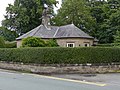 Lodge to Lymm Grammar School.jpg 4.000 × 3.000; 1,43 MB
-
 Lorries at Lymm - geograph.org.uk - 4755534.jpg 1.000 × 753; 477 KB
-
 Lorries at Lymm Services - geograph.org.uk - 4507147.jpg 2.000 × 1.371; 1,51 MB
-
 Lorries at Lymm Services - geograph.org.uk - 4507155.jpg 2.000 × 1.438; 1,64 MB
-
 Lorries at Lymm Services - geograph.org.uk - 4507165.jpg 2.000 × 1.586; 1,57 MB
-
 Lorries at Lymm Services - geograph.org.uk - 6029775.jpg 1.280 × 1.038; 770 KB
-
 Lorries at Lymm Services - geograph.org.uk - 6030481.jpg 1.280 × 960; 799 KB
-
 Lorries at Lymm Services - geograph.org.uk - 6108125.jpg 1.280 × 1.280; 967 KB
-
 Lymm - A6144 Rush Green Road - geograph.org.uk - 1337500.jpg 640 × 480; 223 KB
-
 Lymm - Bollin Drive (Through Portion) - geograph.org.uk - 1337531.jpg 640 × 480; 143 KB
-
 Lymm - Bollin Drive - geograph.org.uk - 1337528.jpg 640 × 480; 142 KB
-

-
 Lymm - Fields By Rush Green Road - geograph.org.uk - 1337505.jpg 640 × 480; 142 KB
-
 Lymm - Fields Off Longbutt Lane - geograph.org.uk - 1337537.jpg 640 × 480; 160 KB
-
 Lymm - geograph.org.uk - 4378498.jpg 1.024 × 766; 713 KB
-
 Lymm - panoramio (2).jpg 2.816 × 2.112; 3,32 MB
-
 Lymm - panoramio (4).jpg 2.288 × 1.712; 1,33 MB
-
 Lymm - panoramio (5).jpg 2.288 × 1.712; 1,52 MB
-
 Lymm - Pool Lane At Brookside Avenue - geograph.org.uk - 1337486.jpg 640 × 480; 164 KB
-
 Lymm - The Avenue - geograph.org.uk - 1337474.jpg 480 × 640; 206 KB
-
 Lymm Archway - geograph.org.uk - 2862888.jpg 640 × 640; 774 KB
-
 Lymm banner.jpg 2.100 × 300; 333 KB
-

-
 Lymm centre - geograph.org.uk - 4378511.jpg 1.024 × 615; 676 KB
-
 Lymm Community Library - geograph.org.uk - 2862799.jpg 640 × 480; 410 KB
-
 Lymm Cross - geograph.org.uk - 4752831.jpg 3.264 × 2.448; 2,12 MB
-
 Lymm Dam and The Dingle - geograph.org.uk - 3985940.jpg 640 × 481; 379 KB
-
 Lymm Dam at Lymm Bridge - geograph.org.uk - 3985934.jpg 640 × 480; 270 KB
-
 Lymm FP32 - geograph.org.uk - 4612765.jpg 1.200 × 900; 356 KB


_-_geograph.org.uk_-_3354460.jpg)

_-_geograph.org.uk_-_3354390.jpg)


_-_geograph.org.uk_-_2862981.jpg)


_-_geograph.org.uk_-_3363941.jpg)
_-_geograph.org.uk_-_3363949.jpg)
_-_geograph.org.uk_-_3363962.jpg)
_-_geograph.org.uk_-_3521360.jpg)
_-_geograph.org.uk_-_3521369.jpg)


_-_geograph.org.uk_-_3363935.jpg)


_now_an_Italian_Restaurant_-_geograph.org.uk_-_3223267.jpg)


_-_geograph.org.uk_-_2862963.jpg)
_-_geograph.org.uk_-_3363978.jpg)
_-_geograph.org.uk_-_3363987.jpg)
_Broomedge_-_geograph.org.uk_-_2862974.jpg)


_-_geograph.org.uk_-_1337531.jpg)


.jpg)
.jpg)
.jpg)


_Squadron_Badge.png)