Category:Marotiri
Aller à la navigation
Aller à la recherche
English: Marotiri is a group of four uninhabited volcanic rocks protruding from the sea (and several submerged rocks), forming the southeastern end of the Austral Islands of French Polynesia. Marotiri is also known as Bass Rocks (Îlots de Bass in French), maybe according to the name of the European explorer George Bass. Marotiri is very isolated, located at west-south-westward of Pitcairn Island. The closest island is Rapa Iti, 75 km further northwest, but separated from it by an ocean depth of more than 1,500 meters. The rocks are part of the municipality of Rapa.
îles de Polynésie française  | |||||
| Téléverser des médias | |||||
| Nature de l’élément | |||||
|---|---|---|---|---|---|
| Partie de | |||||
| Lieu | Polynésie française | ||||
| Baigné par | |||||
| Date de découverte ou d'invention |
| ||||
| Superficie |
| ||||
| Altitude |
| ||||
 | |||||
Média dans la catégorie « Marotiri »
Cette catégorie comprend 9 fichiers, dont les 9 ci-dessous.
-
 Austral isl Marotiri.PNG 540 × 300 ; 6 kio
-

-
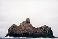 Marotiri - îlot sud.jpg 895 × 600 ; 59 kio
-
 Marotiri Landsat.jpg 508 × 348 ; 56 kio
-
 Marotiri-map.jpg 1 218 × 895 ; 80 kio
-
 Oc,G.T.1575, Mana Expedition to Easter Island, British Museum.jpg 750 × 573 ; 69 kio
-
 Taubenpostbriefmarke.jpg 1 205 × 413 ; 80 kio
-

-


