Category:Mull of Galloway
Zur Navigation springen
Zur Suche springen
headland in Wigtownshire, Dumfries and Galloway, Scotland, UK  | |||||
| Medium hochladen | |||||
| Ist ein(e) | |||||
|---|---|---|---|---|---|
| Ort | Dumfries and Galloway, Schottland | ||||
| Liegt am oder im Gewässer | |||||
 | |||||
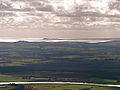
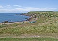
The Mull of Galloway (Scottish Gaelic: Maol nan Gall) is the southernmost point of Scotland. It is situated in the Dumfries and Galloway council area.
Unterkategorien
Diese Kategorie enthält folgende Unterkategorie:
In Klammern die Anzahl der enthaltenen Kategorien (K), Seiten (S), Dateien (D)
M
- Mull of Galloway Lighthouse (113 D)
Medien in der Kategorie „Mull of Galloway“
Folgende 151 Dateien sind in dieser Kategorie, von 151 insgesamt.
-
 Birdwatcher - Mull of Galloway - geograph.org.uk - 2905744.jpg 1.100 × 729; 289 KB
-
 Cafe on the cliff's edge - geograph.org.uk - 1725861.jpg 640 × 480; 325 KB
-
 Cailiness Point - geograph.org.uk - 217063.jpg 640 × 480; 94 KB
-

-

-
 Cliff top on the Mull of Galloway - geograph.org.uk - 1002621.jpg 480 × 640; 114 KB
-
 Cliffs on the Mull of Galloway - geograph.org.uk - 951083.jpg 640 × 433; 83 KB
-
 Coastal heath in the RSPB reserve - geograph.org.uk - 1725870.jpg 640 × 480; 316 KB
-
 Coastline at Portlennie - geograph.org.uk - 3621443.jpg 1.920 × 1.280; 1,36 MB
-
 Country Road - geograph.org.uk - 413497.jpg 640 × 427; 61 KB
-
 Dry stone wall - geograph.org.uk - 1387831.jpg 640 × 480; 98 KB
-
 East Tarbet - geograph.org.uk - 215836.jpg 640 × 480; 67 KB
-
 East Tarbet - geograph.org.uk - 596720.jpg 640 × 480; 91 KB
-
 East Tarbet Bay - geograph.org.uk - 3620831.jpg 1.920 × 1.280; 1,32 MB
-
 East Tarbet Bay - geograph.org.uk - 3620916.jpg 1.920 × 1.280; 1,43 MB
-
 East Tarbet Bay - geograph.org.uk - 3621282.jpg 1.920 × 1.280; 1,22 MB
-
 East Tarbet Quay, Mull of Galloway - geograph.org.uk - 216324.jpg 640 × 480; 83 KB
-
 Female-linnet.jpg 1.902 × 1.359; 1,94 MB
-
 Fierce tidal race off Mull of Galloway - geograph.org.uk - 5265055.jpg 1.024 × 768; 238 KB
-
 Fog Horn, Mull of Galloway - geograph.org.uk - 26400.jpg 640 × 426; 105 KB
-
 Foghorn, Mull of Galloway - geograph.org.uk - 77352.jpg 640 × 480; 89 KB
-
 From the cliff top at the Mull - geograph.org.uk - 1768885.jpg 2.448 × 3.264; 1,72 MB
-
 Gallie Craig - geograph.org.uk - 5549938.jpg 477 × 640; 347 KB
-
 Gallie Craig rocks - geograph.org.uk - 215830.jpg 640 × 480; 63 KB
-
 Gallie Craig, Mull of Galloway - geograph.org.uk - 5073822.jpg 640 × 481; 487 KB
-
 Isthmus of East and West Tarbet Bays - geograph.org.uk - 1387793.jpg 640 × 480; 40 KB
-
 Isthmus path - geograph.org.uk - 1456327.jpg 640 × 457; 313 KB
-
 Kennedy's Cairn, Mull of Galloway - geograph.org.uk - 1722061.jpg 2.592 × 1.944; 1,22 MB
-

-
 Lady Bay - geograph.org.uk - 5554353.jpg 2.548 × 1.678; 1,12 MB
-
 Lady Bay - geograph.org.uk - 6227143.jpg 2.924 × 1.920; 763 KB
-
 Lady Bay - geograph.org.uk - 6227153.jpg 2.976 × 1.984; 2,5 MB
-
 Lagnagatchie - geograph.org.uk - 5550003.jpg 640 × 477; 501 KB
-
 Lifeboat, Mull of Galloway - geograph.org.uk - 5724034.jpg 2.976 × 1.984; 3,58 MB
-
 Lifeboat, Mull of Galloway - geograph.org.uk - 5724041.jpg 2.976 × 1.984; 3,69 MB
-
 Lifeboat, Mull of Galloway - geograph.org.uk - 5724042.jpg 2.976 × 1.984; 3,79 MB
-
 Lifeboat, Mull of Galloway - geograph.org.uk - 5724048.jpg 2.976 × 1.984; 3,52 MB
-

-
 Luce Bay - geograph.org.uk - 5119880.jpg 1.920 × 1.280; 1,09 MB
-

-
 Mind your step - geograph.org.uk - 1725890.jpg 640 × 477; 304 KB
-
 Mull of Galloway - geograph.org.uk - 1455999.jpg 640 × 457; 289 KB
-
 Mull of Galloway - geograph.org.uk - 1456007.jpg 640 × 457; 254 KB
-
 Mull of Galloway - geograph.org.uk - 1456322.jpg 640 × 457; 284 KB
-
 Mull of Galloway - geograph.org.uk - 1456334.jpg 640 × 457; 320 KB
-
 Mull of Galloway - geograph.org.uk - 1456340.jpg 640 × 457; 308 KB
-
 Mull of Galloway - geograph.org.uk - 1456343.jpg 640 × 457; 333 KB
-
 Mull of Galloway - geograph.org.uk - 1456355.jpg 640 × 457; 285 KB
-
 Mull of Galloway - geograph.org.uk - 3622200.jpg 1.920 × 1.280; 1,56 MB
-
 Mull of Galloway - geograph.org.uk - 445817.jpg 640 × 480; 30 KB
-
 Mull of Galloway - panoramio (1).jpg 4.608 × 3.456; 5,89 MB
-
 Mull of Galloway - panoramio (10).jpg 4.608 × 3.456; 5,59 MB
-
 Mull of Galloway - panoramio (11).jpg 4.608 × 3.456; 5,28 MB
-
 Mull of Galloway - panoramio (12).jpg 4.608 × 3.456; 5,53 MB
-
 Mull of Galloway - panoramio (13).jpg 4.608 × 3.456; 3,44 MB
-
 Mull of Galloway - panoramio (14).jpg 3.456 × 4.608; 3,06 MB
-
 Mull of Galloway - panoramio (15).jpg 4.608 × 3.456; 5,64 MB
-
 Mull of Galloway - panoramio (16).jpg 4.608 × 3.456; 6,25 MB
-
 Mull of Galloway - panoramio (17).jpg 4.608 × 3.456; 4,19 MB
-
 Mull of Galloway - panoramio (18).jpg 4.608 × 3.456; 5,95 MB
-
 Mull of Galloway - panoramio (19).jpg 4.608 × 3.456; 5 MB
-
 Mull of Galloway - panoramio (2).jpg 4.608 × 3.456; 5,91 MB
-
 Mull of Galloway - panoramio (20).jpg 4.608 × 3.456; 7,07 MB
-
 Mull of Galloway - panoramio (21).jpg 4.520 × 3.390; 3,77 MB
-
 Mull of Galloway - panoramio (22).jpg 4.442 × 3.332; 3,19 MB
-
 Mull of Galloway - panoramio (23).jpg 4.320 × 3.240; 4,73 MB
-
 Mull of Galloway - panoramio (3).jpg 4.608 × 3.456; 4,19 MB
-
 Mull of Galloway - panoramio (4).jpg 4.608 × 3.456; 6,7 MB
-
 Mull of Galloway - panoramio (5).jpg 4.183 × 2.676; 3,59 MB
-
 Mull of Galloway - panoramio (6).jpg 4.608 × 3.456; 4,07 MB
-
 Mull of Galloway - panoramio (7).jpg 4.608 × 3.456; 5,62 MB
-
 Mull of Galloway - panoramio (8).jpg 4.430 × 3.322; 4,61 MB
-
 Mull of Galloway - panoramio (9).jpg 4.608 × 3.456; 6,58 MB
-
 Mull of Galloway 03911.jpg 2.592 × 1.944; 2,23 MB
-
 Mull of Galloway 03912.jpg 2.592 × 1.944; 2,25 MB
-
 Mull of Galloway 03913.jpg 2.592 × 1.944; 2,34 MB
-
 Mull of Galloway 03918.jpg 2.592 × 1.944; 2,18 MB
-
 Mull of Galloway 05-09-03 33.jpeg 1.800 × 1.350; 904 KB
-
 Mull of Galloway 131936.jpg 3.968 × 2.976; 2,81 MB
-
 Mull of Galloway 131941.jpg 3.968 × 2.976; 2,11 MB
-
 Mull of Galloway 3908.jpg 2.592 × 1.944; 2,02 MB
-
 Mull of Galloway 3909.jpg 2.592 × 1.944; 2,26 MB
-
 Mull of Galloway 6926.jpg 2.592 × 1.936; 1,05 MB
-
 Mull of Galloway 6927.jpg 2.592 × 1.936; 1,23 MB
-
 Mull of Galloway 6933.jpg 2.592 × 1.936; 2,15 MB
-
 Mull of Galloway 6937.jpg 2.592 × 1.936; 3,03 MB
-
 Mull of Galloway 6938.jpg 2.592 × 1.936; 1,44 MB
-
 Mull of Galloway 6944.jpg 2.592 × 1.936; 3,1 MB
-
 Mull of Galloway 6954.jpg 2.592 × 1.936; 1,49 MB
-
 Mull of Galloway 6960.jpg 2.592 × 1.936; 1,14 MB
-
 Mull of Galloway car park - geograph.org.uk - 215816.jpg 640 × 480; 68 KB
-
 Mull of Galloway Cliffs.jpg 640 × 480; 147 KB
-
 Mull of Galloway Coastline - geograph.org.uk - 3621002.jpg 1.920 × 1.280; 1,21 MB
-
 Mull of Galloway Farm and Cottage - geograph.org.uk - 559082.jpg 640 × 480; 92 KB
-
 Mull of Galloway from the west - geograph.org.uk - 1597365.jpg 640 × 421; 47 KB
-
 Mull of Galloway Lighthouse - geograph.org.uk - 3623548.jpg 1.920 × 1.280; 1,37 MB
-
 Mull of Galloway Trail - geograph.org.uk - 3164222.jpg 2.272 × 1.704; 754 KB
-
 Mull of Galloway Trail - geograph.org.uk - 3433239.jpg 1.920 × 1.280; 1,73 MB
-
 Mull of Galloway Trail - geograph.org.uk - 3621286.jpg 1.920 × 1.280; 1,45 MB
-
 Mull of Galloway Trail - geograph.org.uk - 3621289.jpg 1.920 × 1.280; 1,15 MB
-
 Mull of Galloway Trail - geograph.org.uk - 3621436.jpg 1.920 × 1.280; 1,66 MB
-
 Mull of Galloway Trail - geograph.org.uk - 5642074.jpg 2.592 × 1.728; 1,96 MB
-
 Mull of Galloway Trail at East Tarbet with Waymarker - geograph.org.uk - 3621103.jpg 1.920 × 1.280; 1,47 MB
-
 Mull of Galloway Trail at Luce Bay - geograph.org.uk - 3171335.jpg 2.272 × 1.704; 734 KB
-
 Mull of Galloway Trail at Luce Bay - geograph.org.uk - 3171339.jpg 2.272 × 1.704; 726 KB
-
 Mull of Galloway Trail at Luce Bay - geograph.org.uk - 3171344.jpg 2.272 × 1.704; 730 KB
-
 Mull of Galloway Trail Information Board - geograph.org.uk - 3621295.jpg 1.920 × 1.280; 1,39 MB
-
 Mull of Galloway Trail near Carrickamurlan - geograph.org.uk - 3621425.jpg 1.920 × 1.280; 1,45 MB
-
 Mull of Galloway Trail near Chapel Wells - geograph.org.uk - 3621254.jpg 1.920 × 1.280; 1,36 MB
-
 Mull of Galloway Trail near Chapel Wells - geograph.org.uk - 3621261.jpg 1.920 × 1.280; 1,33 MB
-
 Mull of Galloway Trail near Chapel Wells - geograph.org.uk - 3621275.jpg 1.920 × 1.280; 1,59 MB
-
 Mull of Galloway Trail near Chapel Wells - geograph.org.uk - 3621280.jpg 1.920 × 1.280; 1,44 MB
-
 Mull of Galloway Trail near East Tarbet - geograph.org.uk - 3621201.jpg 1.920 × 1.280; 1,3 MB
-
 Mull of Galloway Trail near East Tarbet - geograph.org.uk - 3621228.jpg 1.920 × 1.280; 1,47 MB
-
 Mull of Galloway Trail near Portavaddie - geograph.org.uk - 3621222.jpg 1.920 × 1.280; 1,43 MB
-
 Mull of Galloway Trail near Portavaddie - geograph.org.uk - 3621240.jpg 1.920 × 1.280; 1,71 MB
-
 Mull of Galloway Trail near Portavaddie - geograph.org.uk - 3621249.jpg 1.920 × 1.280; 1,39 MB
-
 Mull of Galloway Trail near Portlennie - geograph.org.uk - 3621444.jpg 1.920 × 1.280; 1,22 MB
-
 Mull of Galloway Trail near Portlennie - geograph.org.uk - 3621449.jpg 1.920 × 1.280; 1,65 MB
-
 Mull of Galloway Trail Plaque - geograph.org.uk - 5642075.jpg 2.592 × 1.728; 3 MB
-
 Mull of Galloway Trail towards East Tarbet - geograph.org.uk - 3621432.jpg 1.920 × 1.280; 1,42 MB
-
 Mull of Galloway Trail towards East Tarbet - geograph.org.uk - 3621442.jpg 1.920 × 1.280; 1,38 MB
-
 Mull of Galloway Trail with Waymarker - geograph.org.uk - 3621434.jpg 1.920 × 1.280; 1,24 MB
-
 Mull of Galloway Trail with Waymarker - geograph.org.uk - 3621441.jpg 1.920 × 1.280; 1,65 MB
-
 Mull of Galloway Visitors' Centre - geograph.org.uk - 215813.jpg 640 × 480; 75 KB
-

-
 Mull of Galloway, looking west from near the lighthouse - geograph.org.uk - 1722044.jpg 2.592 × 1.944; 1,16 MB
-
 Ordnance Survey One-Inch Sheet 79 Stranraer, Published 1963.jpg 8.251 × 9.867; 8,1 MB
-
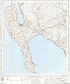
 Ordnance Survey One-Inch Sheet 90 Stranraer, Published 1924.jpg 8.749 × 12.457; 8,71 MB
-
 Path to the Lighthouse - geograph.org.uk - 3623533.jpg 1.920 × 1.280; 1,42 MB
-
 Path to the Lighthouse - geograph.org.uk - 3623544.jpg 1.920 × 1.280; 1,68 MB
-
 Path to West Tarbet - geograph.org.uk - 3622211.jpg 1.920 × 1.280; 1,69 MB
-
-

-
 Rocks at West Tarbet - geograph.org.uk - 3622611.jpg 1.920 × 1.280; 1,61 MB
-
 Scart Cave - geograph.org.uk - 5549971.jpg 427 × 640; 368 KB
-
 Scart Craig - geograph.org.uk - 3137928.jpg 640 × 480; 98 KB
-

-
 Slieve Donard at 100 km.jpg 4.229 × 3.144; 2,97 MB
-
 Snail sanctuary^ - geograph.org.uk - 215817.jpg 640 × 480; 106 KB
-

-
 Stile on Mull of Galloway Trail - geograph.org.uk - 3621429.jpg 1.920 × 1.280; 1,2 MB
-
 Summer on the Mull Of Galloway - geograph.org.uk - 777495.jpg 640 × 366; 92 KB
-
 The North Channel - geograph.org.uk - 5119840.jpg 1.920 × 1.280; 1,49 MB
-
 View over East Tarbet - geograph.org.uk - 3491030.jpg 3.648 × 2.736; 1,27 MB
-
 Wall - geograph.org.uk - 44721.jpg 640 × 480; 74 KB
-
 West Tarbet - geograph.org.uk - 1455987.jpg 640 × 457; 322 KB
-
 West Tarbet - geograph.org.uk - 1456011.jpg 640 × 457; 308 KB
-
 West Tarbet - geograph.org.uk - 1456014.jpg 640 × 457; 299 KB
-
 West Tarbet, Mull of Galloway - geograph.org.uk - 296230.jpg 640 × 428; 56 KB
-
 Yellow Horse caves, Laggantalluch Head - geograph.org.uk - 2666631.jpg 1.024 × 683; 414 KB


.jpg)
.jpg)
.jpg)
.jpg)
.jpg)
.jpg)
.jpg)
.jpg)
.jpg)
.jpg)
.jpg)
.jpg)
.jpg)
.jpg)
.jpg)
.jpg)
.jpg)
.jpg)
.jpg)
.jpg)
.jpg)
.jpg)
.jpg)


