Category:Pottenstein (Upper Franconia)
Saltar para a navegação
Saltar para a pesquisa
town in Landkreis Bayreuth in Germany .jpg)   | |||||
| Carregar ficheiro | |||||
| Áudio da pronúncia | |||||
|---|---|---|---|---|---|
| Instância de |
| ||||
| Parte de |
| ||||
| Localização | Bayreuth, Alta Francónia, Baviera, Alemanha | ||||
| População |
| ||||
| Área |
| ||||
| Altitude |
| ||||
| Diferente de | |||||
| sítio web oficial | |||||
 | |||||
Subcategorias
Esta categoria contém as seguintes 15 subcategorias (de um total de 15).
Páginas na categoria "Pottenstein (Upper Franconia)"
Esta categoria só contém a seguinte página.
Multimédia na categoria "Pottenstein (Upper Franconia)"
Esta categoria contém os seguintes 20 ficheiros (de um total de 20).
-
 AK - Pottenstein - Fränkische Schweiz - 1908.jpg 1 027 × 1 320; 226 kB
-
De-Pottenstein.ogg 2,0 s; 19 kB
-
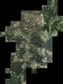 Digitales Orthofoto von Pottenstein (Bayerische Vermessungsverwaltung).tif 30 000 × 40 000; 1,96 GB
-
 Doppel - Kneippanlage im Püttlachtal.jpg 4 608 × 3 456; 11,22 MB
-
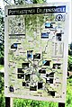 Erlebnismeile.jpg 2 770 × 4 130; 6,1 MB
-
 Fels im Wald (15251800583).jpg 3 888 × 2 592; 10,87 MB
-
 Geotopweg Pottenstein.jpg 4 608 × 3 456; 3,29 MB
-
 Pottenstein 09102010.JPG 4 592 × 3 056; 6,84 MB
-
 Pottenstein IMG 2175.jpg 3 888 × 2 592; 3,84 MB
-
 Pottenstein IMG 2176.jpg 3 888 × 2 592; 3,58 MB
-
 Pottenstein IMG 2182.jpg 3 888 × 2 592; 3,33 MB
-
 Pottenstein IMG 2210.jpg 3 855 × 2 570; 2,27 MB
-
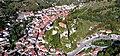
 Pottenstein mit Burg, vom Bayreuther Berg - geo.hlipp.de - 13905.jpg 640 × 480; 100 kB
-
 Pottenstein, Franken. Bayreuther Berg - geo.hlipp.de - 13906.jpg 480 × 640; 92 kB
-
 Pottenstein-ort.jpg 3 717 × 1 727; 2,77 MB
-
 Rastplatz im oberen Püttlachtal - panoramio.jpg 4 608 × 3 456; 3,46 MB
-
 Rastplatz Prechtshöhe - panoramio.jpg 4 608 × 3 456; 2,34 MB
-
 Trockau und Lindenhart (HDR) - panoramio.jpg 4 608 × 2 591; 2,77 MB
-
 Wirtshausschild Pottenstein.jpg 4 000 × 3 000; 2,24 MB
-
 Zeichnung - Pottenstein - R Schiestl - 1909.jpg 1 000 × 845; 115 kB


.jpg)


_-_panoramio.jpg)

