Category:Priddy's Hard
Jump to navigation
Jump to search
area of Gosport, in Hampshire, England  | |||||
| Upload media | |||||
| Instance of | |||||
|---|---|---|---|---|---|
| Location | Gosport, Hampshire, South East England, England | ||||
 | |||||
Subcategories
This category has the following 8 subcategories, out of 8 total.
Media in category "Priddy's Hard"
The following 54 files are in this category, out of 54 total.
-
 "Veneville", Hardway, Gosport - geograph.org.uk - 2797529.jpg 2,592 × 1,944; 839 KB
-

-
 Boats, Portsmouth Harbour - geograph.org.uk - 6473489.jpg 1,024 × 681; 97 KB
-
 Burrow Island - geograph.org.uk - 6479099.jpg 1,024 × 681; 115 KB
-

-

-
 Disused buildings at Priddys Hard - geograph.org.uk - 693168.jpg 640 × 394; 46 KB
-
 Disused Vosper's Jetty, Hardway - geograph.org.uk - 6403280.jpg 1,024 × 768; 338 KB
-
 Earthwork Defences at Priddy's Hard.jpg 4,819 × 3,739; 4.41 MB
-

-
 Explosion - Shifting Room (geograph 6473503).jpg 1,024 × 681; 178 KB
-
 Forton Lake Bridge.jpg 883 × 383; 143 KB
-
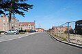
 Gosport - Naval Firepower Museum - geograph.org.uk - 2992705.jpg 800 × 600; 180 KB
-
 Gosport - Priddy's Hard - geograph.org.uk - 2993928.jpg 800 × 600; 148 KB
-
 Gosport - Priddys Hard - geograph.org.uk - 2991147.jpg 800 × 531; 101 KB
-
 Gosport - Priddys Hard - geograph.org.uk - 2993786.jpg 800 × 600; 101 KB
-

-
 Hardway (geograph 3463702).jpg 4,608 × 3,456; 3.28 MB
-
 Hardway, Portsmouth Harbour - geograph.org.uk - 3569861.jpg 640 × 427; 219 KB
-
 Heritage Way (21) - geograph.org.uk - 2929846.jpg 3,872 × 2,592; 4.35 MB
-
 Heritage Way (22) - geograph.org.uk - 2929851.jpg 3,872 × 2,592; 4.39 MB
-
 Heritage Way (23) - geograph.org.uk - 2929855.jpg 3,872 × 2,592; 4.62 MB
-
 Heritage Way (24) - geograph.org.uk - 2929871.jpg 3,872 × 2,592; 4.55 MB
-
 Heritage Way (25) - geograph.org.uk - 2929892.jpg 3,872 × 2,592; 4.66 MB
-
 Heritage Way (26) - geograph.org.uk - 2929899.jpg 3,872 × 2,592; 4.34 MB
-
 Heritage Way (27) - geograph.org.uk - 2929906.jpg 3,872 × 2,592; 4.39 MB
-
 Heritage Way (28) - geograph.org.uk - 2929911.jpg 3,872 × 2,592; 4.63 MB
-

-
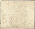 Map showing Fortifications of the Island of Portsea, 1773.jpg 4,000 × 3,311; 2.05 MB
-
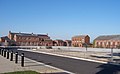
 New Estate, Priddy's Hard - geograph.org.uk - 2785055.jpg 2,592 × 1,944; 838 KB
-
 Number 208 - geograph.org.uk - 2769660.jpg 2,048 × 1,536; 474 KB
-
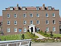
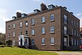 Pearson House, Priddy's Hard.jpg 4,494 × 2,996; 9.73 MB
-
 Piers, Priddy's Hard - geograph.org.uk - 6473488.jpg 1,024 × 681; 120 KB
-
 Pontoon in Portsmouth Harbour - geograph.org.uk - 2135332.jpg 640 × 480; 74 KB
-
 Pontoon in Portsmouth Harbour - geograph.org.uk - 2611784.jpg 1,024 × 768; 88 KB
-
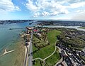
 Portsmouth Harbour - geograph.org.uk - 3546320.jpg 3,264 × 2,448; 2.42 MB
-
 Portsmouth Harbour, Hardway - geograph.org.uk - 3569860.jpg 640 × 427; 214 KB
-
 Remains of Powder Jetty off Priddy's Hard - geograph.org.uk - 6404910.jpg 1,024 × 684; 270 KB
-
 Searle Drive - geograph.org.uk - 2931133.jpg 3,872 × 2,592; 4.19 MB
-
 Seen from a harbour tour (8) - geograph.org.uk - 2135445.jpg 640 × 480; 64 KB
-
 Shell Pier - geograph.org.uk - 6473491.jpg 1,024 × 681; 103 KB
-
 Shell Pier Radar Station - geograph.org.uk - 5932286.jpg 1,024 × 678; 101 KB
-
 Side Arms Store.jpg 1,763 × 1,184; 1.02 MB
-
 Southern tip of Burrow Island - geograph.org.uk - 2612163.jpg 1,024 × 768; 123 KB
-
 The end of Shell Pier - geograph.org.uk - 2612156.jpg 1,024 × 768; 118 KB
-
 View looking north from the Spinnaker Tower - geograph.org.uk - 6399798.jpg 2,592 × 1,944; 1.42 MB
-
 View to Portsmouth 02.08.08 (2) - geograph.org.uk - 2802719.jpg 2,592 × 1,944; 1.25 MB
-
 View to Portsmouth 02.08.08 - geograph.org.uk - 2802716.jpg 2,592 × 1,944; 1.18 MB
-

-
 Wreck - geograph.org.uk - 6617995.jpg 685 × 1,024; 199 KB
-

-

-

-


.jpg)


.jpg)

_-_geograph.org.uk_-_2929846.jpg)
_-_geograph.org.uk_-_2929851.jpg)
_-_geograph.org.uk_-_2929855.jpg)
_-_geograph.org.uk_-_2929871.jpg)
_-_geograph.org.uk_-_2929892.jpg)
_-_geograph.org.uk_-_2929899.jpg)
_-_geograph.org.uk_-_2929906.jpg)
_-_geograph.org.uk_-_2929911.jpg)


_-_geograph.org.uk_-_2135445.jpg)


_-_geograph.org.uk_-_2802719.jpg)


_-_geograph.org.uk_-_5209818.jpg)
_-_geograph.org.uk_-_5209828.jpg)
_-_geograph.org.uk_-_5209831.jpg)
_-_geograph.org.uk_-_5209843.jpg)