Category:Rothaargebirge
Zur Navigation springen
Zur Suche springen
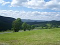
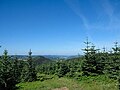
deutsches Mittelgebirge im nordöstlichen Teil des Rheinischen Schiefergebirges  Vista desde Kahler Asten, uno de los picos más altos de la cordillera  | |||||
| Medium hochladen | |||||
| Ist ein(e) | |||||
|---|---|---|---|---|---|
| Ort |
| ||||
| Gebirgszug | |||||
| Höchster Punkt | |||||
| Fläche |
| ||||
| Höhe über dem Meeresspiegel |
| ||||
 | |||||
Unterkategorien
Es werden 36 von insgesamt 36 Unterkategorien in dieser Kategorie angezeigt:
In Klammern die Anzahl der enthaltenen Kategorien (K), Seiten (S), Dateien (D)
- Maps of Rothaargebirge (18 D)
A
B
- Burgberg (Bad Laasphe) (7 D)
C
D
- Dommel (Berg) (2 D)
E
G
- Ginsterkopf (4 D)
H
- Hegekopf (3 D)
- Heidkopf (Olsberg) (8 D)
- Hilmesberg (2 D)
- Hoher Wald (3 D)
I
- Iberg (Olsberg) (2 D)
J
- Jagdberg (Netphen) (8 D)
K
L
- Langenberg (Rothaargebirge) (10 D)
N
- Naturpark Rothaargebirge (26 D)
O
R
S
- Schurenstein (1 D)
- Steinhelle (1 D)
W
- Waldemei (2 D)
- Wallershöhe (1 D)
- Wiedegge (4 D)
Z
- Zwistberg (12 D)
Medien in der Kategorie „Rothaargebirge“
Folgende 103 Dateien sind in dieser Kategorie, von 103 insgesamt.
-
 Alpenhaus.jpg 6.507 × 3.507; 13,02 MB
-
 Amtshausen - Lahnhelle (Elop).jpg 3.584 × 2.688; 980 KB
-
 Arennest.jpg 782 × 244; 75 KB
-
 Baenderschiefer bei Zueschen (Elop).jpg 3.328 × 2.496; 1,63 MB
-
 Baenderschieferpano bei Zueschen (Elop).jpg 7.162 × 2.669; 2,75 MB
-
 Berlar fd (1).JPG 5.184 × 3.888; 6,28 MB
-
 Berlar fd (4).jpg 4.320 × 3.240; 4,68 MB
-
 Berlar fd (5).jpg 4.320 × 3.240; 4,95 MB
-
 Bestwig Stüppelturm Sauerland Ost 736 pk.jpg 4.288 × 2.848; 9,24 MB
-
 Bestwig-Andreasberg Dörnberg Sauerland Ost 735 pk.jpg 4.175 × 2.444; 7,02 MB
-
 Bestwig-Andreasberg Stüppel Sauerland Ost 734 pk.jpg 4.288 × 2.848; 8,8 MB
-
 Bichelbachquelle.jpg 2.048 × 1.536; 1,66 MB
-
 Blüggelscheidt fd (4).JPG 5.184 × 3.888; 6,13 MB
-

-
 Bollerbergpano Ziegenhelle mit Langewiese und Astenberg sowie Sackpfeife und Rimberg (Elop).png 8.298 × 2.642; 15,01 MB
-
 Bracht (Dornheim).JPG 2.048 × 1.536; 931 KB
-
 Die Feuereiche.jpg 3.888 × 16.000; 14,53 MB
-
 Die Hoppekequelle fd.JPG 5.184 × 3.888; 8,21 MB
-
 Ebschloh von Ludwigseck (Elop).jpg 3.584 × 2.688; 1,14 MB
-
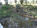
 Ederquelle1.jpg 1.200 × 800; 286 KB
-
 Einhaus fd (2).JPG 5.184 × 3.888; 5,99 MB
-
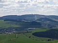 Ettelsberg.jpg 4.000 × 3.000; 2,05 MB
-
 Evang. Kirche von 1878 fd.JPG 5.184 × 3.888; 5,13 MB
-
 Farben des Sauerlandes (10289311586).jpg 3.133 × 2.350; 1,43 MB
-
 Farben des Sauerlandes (10289328195).jpg 2.217 × 2.151; 899 KB
-
 Fredeburger Schiefer bei Silbach (Elop).jpg 3.152 × 2.248; 1,29 MB
-
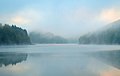 Frühnebel im Rothaargebirge.jpg 3.813 × 2.405; 2,39 MB
-
 Goldener Strauch.JPG 2.048 × 1.536; 743 KB
-
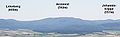
 Gossfelden-Rothaargebirge-beschriftet-beschnitten.jpg 5.776 × 1.312; 3,94 MB
-
 Gossfelden-Rothaargebirge-beschriftet.jpg 5.776 × 1.659; 4,82 MB
-
 Gossfelden-Rothaargebirge-pur.jpg 5.840 × 1.658; 4,4 MB
-
 Gut Hanxleden fd.jpg 2.592 × 1.944; 1,79 MB
-
 Hainchen und Haincher Hoehe (Elop).jpg 2.662 × 1.700; 823 KB
-
 Hallenberg Hallenberger Wald Sauerland Ost 243 pk.jpg 4.288 × 2.848; 10,54 MB
-
 Hallenberg Hallenberger Wald Sauerland Ost 244 pk.jpg 4.088 × 2.715; 8,82 MB
-
 Hansenberg.JPG 3.648 × 2.736; 1,9 MB
-
 Helle Mündung in die Orke.JPG 5.184 × 3.888; 5,67 MB
-
 Hilchenbach mit Hadem vom Steimel.jpg 3.776 × 2.520; 1,4 MB
-
 Hohe Seite, Alte Grimme und Reetsberg vom Bollerberg aus (Elop).jpg 3.584 × 2.688; 1,02 MB
-
 Hoher Wald von Brachthausen aus gesehen.JPG 2.520 × 1.416; 1,05 MB
-
 Homerich und Kindelsberg von der Eisenstraße aus (Elop).jpg 3.584 × 2.688; 967 KB
-
 Kahlenberg und Istenberg (Elop).jpg 3.499 × 1.481; 425 KB
-
 Kahlenbergpano mit Istenberg und Heidkopf (Elop).jpg 8.550 × 2.017; 1,7 MB
-
 Kirchhundem Schwarzbachtal FFSW 3246.jpg 4.039 × 2.687; 13,07 MB
-
 Kirchhundem Schwarzbachtal FFSW 3248.jpg 4.256 × 2.832; 15,62 MB
-
 Kirchrarbach fd (1).jpg 2.592 × 1.944; 843 KB
-
 Kohlenberg.jpg 720 × 290; 77 KB
-
 KulturPur am Giller i.d.N. von Siegen.JPG 1.024 × 768; 272 KB
-
 Lennestadt-Saalhausen Ilberg Rothaargebirge FFSW 3252.jpg 3.642 × 1.947; 8,12 MB
-
 Mosebolle fd (10).JPG 5.184 × 3.888; 5,71 MB
-
 Mönekind fd (1).JPG 5.184 × 3.888; 6,64 MB
-
 Müsen vom Altenberg aus gesehen.JPG 2.592 × 1.936; 2 MB
-
 NSG Abraumhalde der Grube Alexander fd (3).jpg 5.184 × 3.888; 6,47 MB
-
 NSG Bruchhauser Steine fd (3).JPG 5.184 × 3.888; 5,82 MB
-
 NSG Kahler Asten.JPG 5.184 × 3.888; 6,03 MB
-
 NSG Kalkgruppe Brilon Weberstein fd (4).jpg 5.184 × 3.888; 5,89 MB
-
 Oberhenneborn fd (1).JPG 5.184 × 3.888; 7,13 MB
-
 Oberhenneborn fd (3).JPG 5.184 × 3.888; 5,71 MB
-
 Oberhenneborn fd (4).JPG 5.184 × 3.888; 5,15 MB
-
 Olsberg Ohlenberg Sauerland Ost 727 pk.jpg 4.288 × 2.848; 7,43 MB
-
 Orketal fd (2).JPG 5.184 × 3.888; 6,58 MB
-
 Orketal fd (3).JPG 5.184 × 3.888; 5,59 MB
-
 Orketal fd (4).JPG 5.184 × 3.888; 6,48 MB
-
 Ostblick vom kahlen asten ds wv 05 2009.jpg 2.000 × 629; 235 KB
-
 Pano Härdler 2.0.jpg 15.545 × 2.073; 11,64 MB
-
 Panorama vom Härdler nach Osten.jpg 24.590 × 3.000; 60,17 MB
-
 Rarbach Quelle fd (1).JPG 5.184 × 2.920; 6,09 MB
-
 Rarbach Quelle fd (2).JPG 5.184 × 2.920; 5,4 MB
-
 Richtplatz Kurkölnisches Gogericht Hoppernkopf.jpg 4.000 × 3.000; 2,27 MB
-
 Rimberg-Panorama 2014.jpg 18.004 × 1.000; 10,82 MB
-
 Rimberg-Panorama.jpg 9.180 × 900; 6,22 MB
-
 Roßberg im Juni 2014 vom Rimberg.jpg 3.400 × 1.000; 2,29 MB
-
 Rothaargebirge - 0001.jpg 3.888 × 2.592; 6,77 MB
-
 Rothaargebirge Skulptur01.jpg 1.536 × 1.024; 542 KB
-
 Rothaarkamm Hüttenberg mit Buchhelle.jpg 3.776 × 2.520; 1,28 MB
-
 Rothaarkamm mit Wiesental Hilchenbach-Oberndorf.jpg 3.776 × 2.520; 1,45 MB
-
 Rothaarkamm Oberndorfer Höhe.jpg 3.776 × 2.520; 1,65 MB
-
 Rothaarpano von oberhalb Leimstruths (Elop).jpg 9.082 × 2.377; 2,55 MB
-
 Rothaarpano von oberhalb Leimstruths - cropped (Elop).jpg 9.082 × 1.038; 966 KB
-
 Rothaarsteig am Kahlen Asten.jpg 400 × 300; 29 KB
-
 Rueckershausenpano - Birkenhecke-Ebschloh-Hohes Haupt (Elop).jpg 11.010 × 2.391; 2,48 MB
-
 Sackpfeife.jpg 765 × 321; 84 KB
-
 Sassenhausenpano mit Horst und Baerenkopf (Elop).jpg 10.908 × 2.235; 1,76 MB
-
 Sauerland-Stabil-Stuhl-06-Panorama 3.jpg 13.310 × 2.679; 20,8 MB
-
 Schanze.jpg 1.024 × 768; 107 KB
-
 Siegerlandpano Hainchen und Haincher Hoehe (Elop).jpg 5.727 × 2.441; 1,64 MB
-
 Skilift und Skipiste in Winterberg (10570305756).jpg 1.000 × 1.500; 810 KB
-
 Skilift und Skipiste in Winterberg (10570359574).jpg 1.500 × 1.000; 1,02 MB
-
 Spiegelbild des Rothaargebirges.jpg 6.016 × 4.000; 4,88 MB
-
 Sprungschanze.JPG 1.728 × 2.304; 580 KB
-
 Stemmberg, Bollerberg, Winterkasten, Reetsberg und Schlossberg von Medebach aus (Elop).jpg 7.030 × 2.373; 1,76 MB
-
 Stiegelburgpano mit Jagdberg und Nordhoell (Elop).jpg 5.668 × 2.667; 2,35 MB
-
 Sögtrop fd.jpg 2.592 × 1.944; 800 KB
-
 Titmaringhausen Grundwasserbachtal.JPG 5.184 × 3.888; 6,27 MB
-
 Titmaringhausen und Kahle Pön(4).JPG 5.184 × 3.888; 5,46 MB
-
 Topographische Karte Siegen-Wittgenstein.jpg 2.222 × 2.242; 656 KB
-
 Trockental und Deponie am Gelaengeberg Medebach (Elop).jpg 4.509 × 2.484; 1,51 MB
-
 Unteres Helletal fd (1).jpg 5.184 × 3.888; 6,3 MB
-
 Unteres Helletal fd (2).jpg 5.184 × 3.888; 5,69 MB
-
 Wanderhöhepunkt Wegzeichen.jpg 1.200 × 900; 280 KB
-
 Winterberg-Niedersfeld Langenberg Sauerland Ost 336 pk.jpg 4.288 × 2.848; 9,17 MB
-
 Wittgensteiner Kammer mit Asten und Ziegenhelle (Elop).jpg 4.119 × 2.707; 1,16 MB
-


.jpg)
.jpg)
.JPG)
.jpg)
.jpg)


.JPG)
.JPG)

.jpg)

.JPG)


.jpg)
.jpg)
.jpg)


.jpg)


.jpg)

.jpg)
.jpg)


.jpg)


.JPG)
.JPG)

.jpg)
.JPG)

.jpg)
.JPG)
.JPG)
.JPG)

.JPG)
.JPG)
.JPG)
.JPG)
.JPG)


.jpg)
.jpg)
.jpg)


.jpg)


.JPG)

.jpg)
.jpg)
.jpg)


.jpg)
.jpg)
.jpg)
.jpg)
.png)
.jpg)
.jpg)
.jpg)
.jpg)
.jpg)
.jpg)
Kategorien:
- Low mountain ranges of North Rhine-Westphalia
- Low mountain ranges of Hesse
- Mountain ranges of Hochsauerlandkreis
- Mountain ranges of Kreis Olpe
- Mountain ranges of Kreis Siegen-Wittgenstein
- Mountain ranges of Landkreis Marburg-Biedenkopf
- Mountain ranges of Landkreis Waldeck-Frankenberg
- Landscapes of Hesse
- Regions of North Rhine-Westphalia