Category:Selby to Driffield Line
Zur Navigation springen
Zur Suche springen
Eisenbahnstrecke im Vereinigten Königreich | |||||
| Medium hochladen | |||||
| Ist ein(e) | |||||
|---|---|---|---|---|---|
| Ort |
| ||||
| Eröffnungsdatum |
| ||||
| Auflösungsdatum |
| ||||
| Endpunkt (Objekt) | |||||
| |||||
Unterkategorien
Es werden 12 von insgesamt 12 Unterkategorien in dieser Kategorie angezeigt:
In Klammern die Anzahl der enthaltenen Kategorien (K), Seiten (S), Dateien (D)
B
- Bainton railway station (2 D)
- Bubwith Rail Trail (27 D)
- Bubwith railway station (2 D)
C
D
- Driffield railway station (12 D)
E
- Enthorpe Cutting (4 D)
- Everingham railway station (6 D)
F
- Foggathorpe railway station (2 D)
H
- High Field railway station (3 D)
- Holme Moor railway station (8 D)
M
S
- Selby railway station (42 D)
Medien in der Kategorie „Selby to Driffield Line“
Folgende 23 Dateien sind in dieser Kategorie, von 23 insgesamt.
-
 A house on Breighton Road, Gunby - geograph.org.uk - 807472.jpg 640 × 480; 255 KB
-
 Beverley to Market Weighton Railway - geograph.org.uk - 10578.jpg 640 × 480; 133 KB
-
 Bridge Number 05 - geograph.org.uk - 1562276.jpg 640 × 480; 99 KB
-
 Dismantled railway track, Menthorpe Gate (geograph 2359184).jpg 1.600 × 1.200; 582 KB
-
 Disused Railway Bridge, Goodmanham Road - geograph.org.uk - 1563839.jpg 640 × 480; 108 KB
-
 Disused Railway Line - geograph.org.uk - 6868.jpg 640 × 480; 117 KB
-
 Enthorpe Station (Ex) - geograph.org.uk - 12022.jpg 640 × 483; 88 KB
-
 Former viaduct at Warren Dale - geograph.org.uk - 9540.jpg 640 × 480; 162 KB
-
 Menthorpe Gate railway station (site), Yorkshire (geograph 3521487).jpg 1.024 × 768; 182 KB
-
 Middleton-on-the-Wolds railway station (site), Yorkshire (geograph 3519963).jpg 1.024 × 768; 205 KB
-
 Old Railway Line - geograph.org.uk - 11208.jpg 640 × 483; 104 KB
-
 Railway Bridge Goodmanham.jpg 640 × 480; 124 KB
-
 Railway Bridge near Goodmanham - geograph.org.uk - 1432017.jpg 640 × 480; 79 KB
-
 Railway Bridge near Goodmanham - geograph.org.uk - 632299.jpg 480 × 640; 118 KB
-
 Ruin by the track (geograph 6108676).jpg 1.024 × 768; 297 KB
-
 Ruins of a railway bridge on Oldfield Lane (geograph 6495301).jpg 5.456 × 3.632; 3,89 MB
-
 Station Cottages Southburn.jpg 640 × 427; 382 KB
-

-

-

-
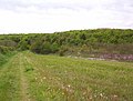
 The old railway line looking north east - geograph.org.uk - 420430.jpg 640 × 480; 143 KB
-

-
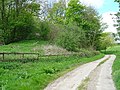
 Track down to Old Railway line - geograph.org.uk - 12079.jpg 640 × 483; 102 KB


.jpg)


_-_geograph.org.uk_-_12022.jpg)

,_Yorkshire_(geograph_3521487).jpg)
,_Yorkshire_(geograph_3519963).jpg)


.jpg)
.jpg)


