Category:Soil creep
Zur Navigation springen
Zur Suche springen
Deutsch: Solifluktion, Bodenfließen
English: en:Soil creep, solifluction
Français : Reptation
Italiano: Reptazione
slow, downward progression of rock and soil down a low grade slope | |||||
| Medium hochladen | |||||
| Unterklasse von |
| ||||
|---|---|---|---|---|---|
| |||||
Unterkategorien
Es werden 4 von insgesamt 4 Unterkategorien in dieser Kategorie angezeigt:
In Klammern die Anzahl der enthaltenen Kategorien (K), Seiten (S), Dateien (D)
Medien in der Kategorie „Soil creep“
Folgende 22 Dateien sind in dieser Kategorie, von 22 insgesamt.
-
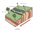 Soil Creep.tif 2.004 × 1.787; 10,27 MB
-
 Abandoned farmstead in Öxnadalsheiði.jpg 604 × 900; 162 KB
-
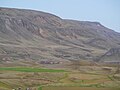
 Auðólfsstaðir beneath Langadalsfjall.jpg 1.543 × 900; 214 KB
-
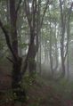 Bieszczady beech01.jpg 413 × 600; 86 KB
-
 Corp1000 - Flickr - NOAA Photo Library.jpg 1.716 × 1.140; 1,14 MB
-
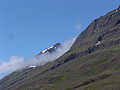
 Dickson Land Høgskulefjellet IMG 7100.JPG 3.456 × 1.344; 1,79 MB
-
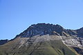
 Escarpment, Edburton Hill - geograph.org.uk - 495658.jpg 640 × 441; 142 KB
-
 Grand mesa creep.jpg 4.608 × 3.456; 6,68 MB
-
 Hillside moving over a sidewalk.jpg 576 × 432; 100 KB
-
 Hofsstaðakirkja.JPG 3.628 × 2.509; 2,49 MB
-
 Iceland 4810.JPG 3.264 × 2.448; 3,02 MB
-
 Island Am Rande des Hochlands 06.JPG 3.444 × 2.586; 1,46 MB
-
 Island Bolungarvik 7.JPG 3.444 × 2.586; 949 KB
-
 Kaiseregg 3309.jpg 3.888 × 2.592; 3,21 MB
-
 Küngsmaisäss 02.JPG 4.288 × 2.848; 2,96 MB
-
 Le Reculet East View.jpg 1.704 × 2.272; 1,58 MB
-
 Piz Traunter Ovas from Val Bever.jpg 2.592 × 1.944; 1,7 MB
-
 Ridge along the north slope of Öxnadalur.jpg 1.200 × 800; 272 KB
-
 Seydisfjördur.jpg 1.544 × 1.024; 240 KB
-
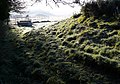 Soil Creep Tracks near Kingston Russell - geograph.org.uk - 1075569.jpg 640 × 450; 112 KB
-
 Solifluction - geograph.org.uk - 475616.jpg 640 × 414; 196 KB
-
 Trees showing the presence of creep.jpg 432 × 576; 109 KB


