Category:Spencer Gulf
Hopp til navigering
Hopp til søk
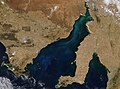
English: Spencer Gulf is between Eyre Peninsula and Yorke Peninsula in South Australia. Australian maps would call it part of Southern Ocean, but many foreign maps would include it into Indian Ocean.
large inlet in South Australia  | |||||
| Last opp mediefiler | |||||
| Forekomst av | |||||
|---|---|---|---|---|---|
| Oppkalt etter | |||||
| Plassering | Sør-Australia, Australia | ||||
| Innløpende elv(er) |
| ||||
 | |||||
Underkategorier
Denne kategorien har følgende 6 underkategorier, av totalt 6.
D
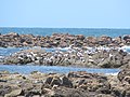
- Dangerous Reef, South Australia (6 filer)
P
- Point Lowly Lighthouse (13 filer)
T
- Taylor Island, South Australia (1 fil)
- Tiparra Reef (2 filer)
W
- Wallaroo Port (21 filer)
- Wardang Island (4 filer)
Filer i kategorien «Spencer Gulf»
Følgende 40 filer er i denne kategorien, av totalt 40.
-
 25 Boston Bay 17.JPG 1 600 × 1 200; 325 KB
-
 27 Mt Remarkable CP 45.JPG 1 600 × 1 200; 263 KB
-
 27 Mt Remarkable CP 47.JPG 1 600 × 1 200; 324 KB
-
 Admiralty Chart No 1762 Gulf of St Vincent and Approaches, Published 1956.jpg 16 236 × 11 103; 52,92 MB
-
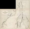
 Admiralty Chart No 2389a Gulfs of St. Vincent and Spencer, Southern sheet, Published 1874.jpg 11 664 × 7 948; 26,97 MB
-
-
 Australia.A2010283.0435.250m (cropped).jpg 1 149 × 1 386; 751 KB
-
 Australia.A2010283.0435.250m.jpg 2 800 × 3 600; 2,88 MB
-
 Boston Island (7052154701) (cropped).jpg 701 × 478; 106 KB
-
 Boston Island (7052154701).jpg 1 020 × 696; 135 KB
-
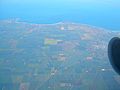
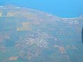
 Central-Yorke-Peninsula-aerial-view-1226.jpg 2 048 × 1 536; 1,67 MB
-
 Copper-Triangle-aerial-view-1217.jpg 2 048 × 1 536; 1,68 MB
-
 Copper-Triangle-aerial-view-1219.jpg 2 048 × 1 536; 1,57 MB
-
 Copper-Triangle-aerial-view-1221.jpg 2 048 × 1 536; 1,69 MB
-
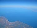
 Cowell-aerial-view-1214.jpg 2 048 × 1 536; 1,58 MB
-
 Cowell-aerial-view-1215.jpg 2 048 × 1 536; 1,58 MB
-
 Crested Terns Lipson Cove Conservation Park.jpg 3 264 × 2 448; 1,92 MB
-
 Hammerhead Shark Island (Stickney) (22502006521).jpg 1 501 × 914; 509 KB
-
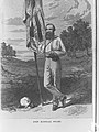 John McDouall Stuart(GN00157).jpg 2 448 × 3 264; 1,19 MB
-
 Kadina-Wallaroo-aerial-view-1220.jpg 2 048 × 1 536; 1,62 MB
-
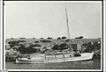 Lifeboat at Grindal Island, South Australia (ca. 1950).jpg 700 × 480; 25 KB
-
 Lipson Cove Dolphins.jpg 640 × 480; 162 KB
-
 Lipson Island Conservation Fairy Penguin.jpg 1 920 × 2 560; 1,08 MB
-

-
 Moonta, SA banner.jpg 3 872 × 553; 542 KB
-
 Moonta-aerial-view-1223.jpg 2 048 × 1 536; 1,69 MB
-
 MoontaBayJetty.JPG 3 872 × 2 592; 2,16 MB
-
 Port Augusta Government Wharf(GN00257).jpg 3 264 × 2 448; 1 021 KB
-
 Satellite image of Spencer Gulf and Gulf St Vincent, South Australia (NASA image).png 2 151 × 2 151; 5,53 MB
-
 Southern Right Whales Lipson Cove.jpg 2 560 × 1 134; 701 KB
-
 Spencer Gulf (MODIS 2019-08-22).jpg 2 513 × 2 080; 464 KB
-
 Spencer Gulf (MODIS 2021-12-28).jpg 1 726 × 1 287; 249 KB
-
 Spencer Gulf.jpg 998 × 499; 88 KB
-
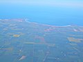
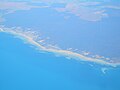 Spencer-Gulf-shoals-between-Whyalla-and-Cowell-aerial-view-1212.jpg 2 048 × 1 536; 1,51 MB
-
 SpencerGulf TaylorIsland2.jpg 562 × 568; 119 KB
-
 Wallaroo-aerial-view-1218.jpg 2 048 × 1 536; 1,64 MB
-
 Whyalla-to-Cowell-aerial-view-1212.jpg 2 048 × 1 536; 1,6 MB
-
 Yorke-Peninsula-aerial-view-1225.jpg 1 536 × 2 048; 1,7 MB
-
 Yorke-Peninsula-and-Wardang-Island-aerial-view-1222.jpg 2 048 × 1 536; 1,56 MB
-
 Yorke-Peninsula-and-Wardang-Island-aerial-view-1224.jpg 2 048 × 1 536; 1,66 MB


.jpg)
_(cropped).jpg)
.jpg)


_(22502006521).jpg)
.jpg)

.jpg)


.jpg)
.png)

.jpg)
.jpg)


