Category:St James', Longborough
Jump to navigation
Jump to search
| Object location | | View all coordinates using: OpenStreetMap |
|---|
church in Longborough, Gloucestershire, UK  | |||||
| Upload media | |||||
| Instance of | |||||
|---|---|---|---|---|---|
| Location | Longborough, Cotswold, Gloucestershire, South West England, England | ||||
| Diocese | |||||
| Heritage designation |
| ||||
| Inception |
| ||||
| Religion or worldview | |||||
| official website | |||||
 | |||||
Subcategories
This category has only the following subcategory.
S
Media in category "St James', Longborough"
The following 13 files are in this category, out of 13 total.
-
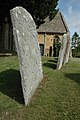 Gravestones, Longborough churchyard - geograph.org.uk - 1445797.jpg 426 × 640; 97 KB
-
 Cottages and church, Longborough - geograph.org.uk - 1448542.jpg 426 × 640; 88 KB
-
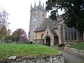
 St James Longborough.jpg 2,592 × 1,944; 1.08 MB
-
 St James' church, Longborough - geograph.org.uk - 1579759.jpg 640 × 480; 93 KB
-
 St James's Church, Longborough - geograph.org.uk - 246852.jpg 640 × 480; 68 KB
-
 St James, Longborough Gloucestershire - geograph.org.uk - 343104.jpg 423 × 640; 70 KB
-
 St James, Longborough Gloucestershire - geograph.org.uk - 343107.jpg 416 × 640; 68 KB
-
 Longborough Church - geograph.org.uk - 1445794.jpg 640 × 426; 78 KB
-
 Longborough Church - geograph.org.uk - 1445800.jpg 640 × 426; 76 KB
-
 Longborough Church - geograph.org.uk - 1445801.jpg 426 × 640; 88 KB
-
 St James's church, Longborough - geograph.org.uk - 2075818.jpg 2,000 × 3,008; 1.6 MB
-

-
 Village green, Longborough - geograph.org.uk - 246783.jpg 640 × 480; 66 KB


