Category:Standon Lordship
Jump to navigation
Jump to search
This is a category about listed building number 1347501. |
| Object location | | View all coordinates using: OpenStreetMap |
|---|
architectural structure in Standon, East Hertfordshire, England, UK  | |||||
| Upload media | |||||
| Instance of | |||||
|---|---|---|---|---|---|
| Location | Standon, East Hertfordshire, Hertfordshire, East of England, England | ||||
| Founded by |
| ||||
| Heritage designation |
| ||||
 | |||||
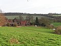
English: Standon Lordship, or "The Lordship" was a country house (now two houses) built in the 1540s for Sir Ralph Sadler (1507–1587). There is a stone plaque with "1546" next to the entrance. Elizabeth I spent three days at Standon Lordship in 1561. Fragmentary remains of the Tudor courtyard house were extended circa 1872 by John Thorpe for the 2nd Duke of Wellington. It was extensively renovated after a fire in 1927.
Media in category "Standon Lordship"
The following 12 files are in this category, out of 12 total.
-
 GOC Braughing 029 The Lordship, Standon (8432529826).jpg 4,288 × 3,216; 3.87 MB
-
 GOC Braughing 031 The Coach House, Standon Lordship (8432530334).jpg 4,288 × 3,216; 4.23 MB
-
 GOC Braughing 033 The Lordship, Standon (8432530710).jpg 3,086 × 2,314; 2.68 MB
-
 GOC Braughing 034 The Lordship, Standon (8431447403).jpg 4,288 × 3,216; 3.87 MB
-
 GOC Braughing 065 The Lordship, Standon (8440065577).jpg 4,288 × 3,216; 3.83 MB
-
 GOC Braughing 066 The Lordship, Standon (8441157142).jpg 3,759 × 2,819; 3.18 MB
-
 Standon Lordship 3.png 1,273 × 929; 1,015 KB
-
 Standon Lordship, Hertfordshire 1.png 1,110 × 776; 807 KB
-
 Standon Lordship, Hertfordshire 2.png 1,135 × 747; 1.09 MB
-
 Standon Lordship, Hertfordshire.jpg 456 × 282; 74 KB
-
 Standon Lordship, West Front.png 1,468 × 976; 1.59 MB
-
 The Lordship - geograph.org.uk - 322268.jpg 640 × 480; 132 KB
.jpg)
.jpg)
.jpg)
.jpg)
.jpg)
.jpg)


