Category:Swaledale
Przejdź do nawigacji
Przejdź do wyszukiwania
valley in North Yorkshire, England, UK  | |||||
| Prześlij plik multimedialny | |||||
| Jest to | |||||
|---|---|---|---|---|---|
| Położony na terenie chronionym | |||||
| Miejsce | North Yorkshire (dystrykt), North Yorkshire, Yorkshire and the Humber, Anglia | ||||
 | |||||
en: Swaledale is one of the northernmost dales in the Yorkshire Dales National Park in Northern England. It is the dale (valley) of the River Swale on the east side of the Pennines in North Yorkshire.
Podkategorie
Poniżej wyświetlono 17 spośród wszystkich 17 podkategorii tej kategorii.
A
C
- Crackpot, North Yorkshire (17 plików)
E
- East Gill Force (14 plików)
G
- Gunnerside Beck (16 plików)
L
- Long Close Bridge (3 pliki)
M
O
- Old Gang Lead Smelting Mill (11 plików)
R
- Robert Whillance's Leap (monument) (6 plików)
S
- Swaledale sheep (32 pliki)
Pliki w kategorii „Swaledale”
Poniżej wyświetlono 80 spośród wszystkich 80 plików w tej kategorii.
-
 2012 Swaledale Blades Low Row.jpg 2560 × 1707; 1,88 MB
-
 2013 Clapper bridge Blakethwaite.jpg 4076 × 3024; 6,52 MB
-
 2014 Fremington Edge 2.jpg 4608 × 2880; 4,96 MB
-
 2014 River Swale.jpg 4608 × 3456; 9,18 MB
-
 2014 Yorkshire Dales country road Swaledale Askrigg.jpg 7147 × 3234; 17,87 MB
-
 2014-09 Richmond Castle Walk.jpg 4608 × 3456; 10,32 MB
-
 2015 Keld Swaledale.jpg 4000 × 2500; 6,09 MB
-
 2015 Pennine Way Kisdon Swinner Gill ks01.jpg 4180 × 2786; 6,1 MB
-
 2015 Swaledale from Kisdon Hill.jpg 4608 × 3072; 7,21 MB
-
 2015-C2C-Swaledale.jpg 4608 × 3072; 7,39 MB
-
 Autumn Colours in Swaledale - geograph.org.uk - 1049653.jpg 640 × 471; 104 KB
-
 Bridleway to Groovebeck - geograph.org.uk - 791226.jpg 570 × 640; 157 KB
-
 Buttercup covered pasture, Swaledale - geograph.org.uk - 1334382.jpg 640 × 480; 122 KB
-
 Countryside, Swaledale - geograph.org.uk - 1391795.jpg 640 × 480; 81 KB
-
 CrackpotHallAndSwaledale(GordonHatton)Oct2003.jpg 640 × 452; 74 KB
-
 Duckingdub Bridge - geograph.org.uk - 815792.jpg 480 × 640; 162 KB
-
 East Stonesdale, Keld, North Yorkshire.jpg 4608 × 3456; 10,45 MB
-
 EastApplegarth.jpg 1280 × 960; 342 KB
-
 Feetham.jpg 640 × 480; 76 KB
-
 Fieldhouse in Swaledale - geograph.org.uk - 1358575.jpg 640 × 427; 121 KB
-
 GreatLangtonAndRiverSwale(Bruffy)May2005.jpg 640 × 480; 79 KB
-

-
 Keld looking westwards.jpg 3600 × 2400; 8,45 MB
-
 Kisdon Hill from Pennine Way 1.jpg 1958 × 1469; 107 KB
-
 Looking down Swaledale - geograph.org.uk - 815766.jpg 640 × 480; 62 KB
-
 Looking over Keld.jpg 3600 × 2400; 9,05 MB
-
 Looking west near Usha Gap - geograph.org.uk - 814773.jpg 640 × 480; 69 KB
-
 Marrick Priory Activity Centre.jpg 2048 × 1536; 756 KB
-
 Marrick Priory, Swaledale, from main road.jpg 5184 × 3888; 10,36 MB
-
 Muirburn at Whitaford Moor, Swaledale, Yorkshire.jpg 4896 × 2752; 4,73 MB
-
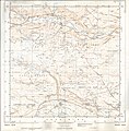
 Ordnance Survey One-Inch Sheet 20 Hawes, Published 1907.jpg 12 196 × 8442; 14,22 MB
-
 Ordnance Survey Sheet SD 99 Askrigg, Published 1960.jpg 7395 × 7536; 5,55 MB
-
 Ordnance Survey Sheet SE 09 Reeth, Published 1961.jpg 7407 × 7525; 5,26 MB
-
 Population of Swaledale.svg 3300 × 1500; 117 KB
-
 Red cow, Swaledale.jpg 360 × 542; 176 KB
-
 Reeth Bridge.jpg 4608 × 3456; 10,77 MB
-
 Reeth from west.jpg 4608 × 3456; 10,45 MB
-
 Reeth, the Swale meanders - geograph.org.uk - 798186.jpg 640 × 480; 60 KB
-
 River Swale in Great Langton.jpg 640 × 480; 87 KB
-
 St Andrew's Church, Grinton, Swaledale, Yorkshire, England.jpg 1920 × 1080; 813 KB
-
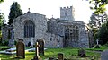 St Andrew's Church, Grinton, Swaledale, Yorkshire.jpg 1920 × 1080; 790 KB
-
 Stepping Stones Swale Healaugh.jpg 3456 × 4608; 9,71 MB
-
 Straw Beck - geograph.org.uk - 882046.jpg 640 × 457; 346 KB
-
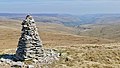
 Summit Cairn, Kisdon Hill.jpg 1395 × 1107; 90 KB
-
 Swale River at Richmond 01.JPG 1931 × 1650; 926 KB
-
 Swale River at Richmond 02.JPG 1653 × 1541; 831 KB
-
 Swale River at Richmond 03.JPG 2031 × 1757; 946 KB
-
 Swaledale 01.JPG 1943 × 1512; 440 KB
-
 Swaledale Cheese cowsmilk.jpg 2924 × 2480; 4,74 MB
-
 Swaledale From Great Shunner Fell - Flickr - ARG Flickr.jpg 5373 × 3024; 10 MB
-
 Swaledale Landscape (42417300134).jpg 3648 × 2497; 5,29 MB
-
 Swaledale Landscape (42417301004).jpg 3648 × 2157; 4,36 MB
-
 Swaledale Landscape (42417302594).jpg 3648 × 2238; 4,6 MB
-
 Swaledale Landscape (42417303454).jpg 3648 × 2736; 5,29 MB
-
 Swaledale Landscape (42417304534).jpg 3648 × 2736; 5,3 MB
-
 Swaledale Landscape (42417305334).jpg 3648 × 2736; 5,42 MB
-
 Swaledale North of Muker - geograph.org.uk - 97879.jpg 640 × 480; 107 KB
-
 Swaledale panorama from Whitaside Moor.jpg 25 332 × 2038; 34,95 MB
-
 Swaledale Road to Askrigg.jpg 3456 × 3456; 6,83 MB
-
 Swaledale-Gunnerside.jpg 2560 × 1920; 1,94 MB
-
 Swaledale-web.jpg 720 × 477; 99 KB
-
 The B6270 and Low Bridge, Swaledale - geograph.org.uk - 1336366.jpg 640 × 480; 108 KB
-
 The Old Temperance Bed And Breakfast And Bookshop.jpg 4032 × 3024; 3,36 MB
-
 Tractor at work at the bottom of West Stonesdale.jpg 3600 × 2400; 8,87 MB
-
 Upper Swaledale Kisdon.png 1114 × 844; 1,09 MB
-
 Wain Wath Force.jpg 3600 × 2400; 9,4 MB
-
 Walled Lane - geograph.org.uk - 817071.jpg 640 × 480; 94 KB
-
 Wesleyan Chapel, Reeth, Yorkshire.jpg 4032 × 3024; 3,95 MB
-
 Whiteaside Muirburn, Swaledale, Yorkshire.jpg 4896 × 2752; 4,94 MB
-
 Across the Swale at Satron - geograph.org.uk - 1023717.jpg 640 × 437; 65 KB
-
 Looking down on the river Swale - geograph.org.uk - 689234.jpg 640 × 480; 138 KB
-
 Swaledale - geograph.org.uk - 360912.jpg 640 × 480; 92 KB
-
 Swaledale from above Crow Trees - geograph.org.uk - 98482.jpg 640 × 427; 92 KB
-
 Swaledale from Jingle Pot Edge - geograph.org.uk - 459015.jpg 640 × 480; 80 KB
-
 Swaledale from Whitaside - geograph.org.uk - 339846.jpg 483 × 640; 72 KB
-
 Swaledale looking towards Gunnerside - geograph.org.uk - 459010.jpg 640 × 480; 86 KB
-
 Swaledale near Kearton - geograph.org.uk - 307893.jpg 640 × 415; 63 KB
-
 Swaledale near Marrick Priory - geograph.org.uk - 276592.jpg 640 × 480; 99 KB
-
 Swaledale, Yorkshire - geograph.org.uk - 32000.jpg 600 × 450; 110 KB
-
 Upper Swaledale - geograph.org.uk - 242888.jpg 640 × 384; 85 KB


Oct2003.jpg)


May2005.jpg)
.jpg)


.jpg)
.jpg)
.jpg)
.jpg)
.jpg)
.jpg)


