Category:Thasitische Peraia
Zur Navigation springen
Zur Suche springen
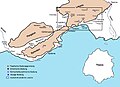
Deutsch: Die Thasitische Peraia umfasst die antiken Siedlungsgebiete des Inselstaates Thasos auf dem gegenüberliegenden Festland mit dem Symvolon-, Pangaion- und Lekani-Gebirge.
Festlandsbesitz von Thasos von etwa Mitte des 7. Jahrhunderts v. Chr. bis zur Beherrschung durch die Makedonier | |||||
| Medium hochladen | |||||
| Ist ein(e) | |||||
|---|---|---|---|---|---|
| Ort |
| ||||
| |||||
Medien in der Kategorie „Thasitische Peraia“
Folgende 20 Dateien sind in dieser Kategorie, von 20 insgesamt.
-
 06.09 Rachoni Pangaion 2.jpg 2.193 × 1.645; 304 KB
-
 1. Hochtal C.jpg 1.149 × 586; 157 KB
-
 2. Hochtal C.jpg 1.152 × 695; 191 KB
-
 Analepsis C.jpg 1.154 × 740; 176 KB
-
 Antiphilippi C.jpg 748 × 985; 89 KB
-
 Ausschnitt der südwestlichen Lekanis C.jpg 400 × 244; 38 KB
-
 Bergbau und Hoehensiedlungen C.jpg 1.340 × 908; 210 KB
-
 Derbenti C.jpg 788 × 1.052; 118 KB
-
 Grubenplan Goldbergwerk Mandra Kari mit Beprobungsstellen C.jpg 1.781 × 1.321; 215 KB
-
 Kortokopi I u. II C.jpg 930 × 750; 113 KB
-
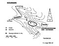 Kourneri C.jpg 861 × 677; 66 KB
-
 Mati C.jpg 893 × 1.103; 164 KB
-
 Mati und Koutra C.jpg 1.260 × 900; 360 KB
-
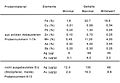 Metallgehalt C.jpg 1.852 × 1.288; 160 KB
-
 Moustheni Tsali C.jpg 5.279 × 1.376; 1,32 MB
-
 Palaiokastro C.jpg 1.102 × 897; 164 KB
-
 Samakovo C.jpg 818 × 693; 63 KB
-
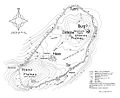
 Siedlungen in der Peraia C.jpg 1.104 × 800; 122 KB
-
 Tsali C.jpg 984 × 1.518; 238 KB
-
 Vortrieb in Mandra Kari C.jpg 1.044 × 1.491; 607 KB


