Category:U.S. Route 191 in Arizona
Jump to navigation
Jump to search
 | number: | (one hundred ninety-one) |
|---|---|---|
| U.S. Highways in Arizona: | 180 · 191 |
section of U.S. Numbered Highway in Arizona, United States  | |||||
| Upload media | |||||
| Instance of | |||||
|---|---|---|---|---|---|
| Part of | |||||
| Location |
| ||||
| Transport network | |||||
| Owned by | |||||
| Maintained by | |||||
| Inception |
| ||||
| Length |
| ||||
| Terminus | |||||
| |||||
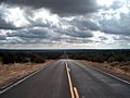
English: Media related to U.S. Route 191 in Arizona (US 191), a 509.18-mile (819.45 km) section of U.S. Numbered Highway in Arizona, United States, that connects Avenida Panamericana in Mexico with US 191 in Utah.
Subcategories
This category has the following 2 subcategories, out of 2 total.
C
- Coronado Trail Scenic Byway (22 F)
Media in category "U.S. Route 191 in Arizona"
The following 22 files are in this category, out of 22 total.
-
 2013-365-265 Available And Ready is ds106 (9891197964).jpg 5,184 × 3,456; 6.69 MB
-
 Apache County, AZ, USA - panoramio (14).jpg 3,264 × 2,448; 2.9 MB
-
 Apache County, AZ, USA - panoramio (15).jpg 2,448 × 3,264; 2.9 MB
-
 Arizona State Route 261 map.svg 1,001 × 586; 102 KB
-
 Arizona State Route 564 map.svg 1,001 × 586; 74 KB
-
 DbwFnN WkAETSrK.jpg 1,200 × 800; 280 KB
-
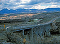 GILA RIVER BRIDGE.jpg 4,956 × 3,624; 2.11 MB
-
 Horseshoe 2 Fire, Arizona.JPG 4,256 × 2,832; 7.92 MB
-
 It's Raining on Someone Else (15016756706).jpg 2,628 × 1,971; 1.29 MB
-
 Junction 160 and 191 1.jpg 5,616 × 3,744; 7.03 MB
-
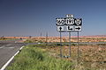 Junction 160 and 191 2.jpg 5,616 × 3,744; 8.77 MB
-
 Mount Graham, U.S. 191, south of Safford, Arizona (5).jpg 2,816 × 2,112; 2.1 MB
-
 NE AZ-NW NM NASA.jpg 990 × 830; 645 KB
-
 Pinaleno Mountains from West.40929.JPG 3,621 × 1,929; 3.54 MB
-
 State Route 78 (AZ-NM) map.svg 1,001 × 586; 68 KB
-
 U.S. 191, Chinle Valley, Navajo Nation, Arizona (14311669330).jpg 4,000 × 3,000; 8.44 MB
-
 U.S. 191, near Chiricahua National Monument (2).jpg 2,816 × 2,112; 2.1 MB
-
 U.S. 191, near Chiricahua National Monument (3).jpg 2,816 × 2,112; 2.04 MB
-
 U.S. Route 191 NM Beautiful Valley 2006 09 06.jpg 3,504 × 2,336; 2.36 MB
-
 U.S. Routes 60,180 &, 191.jpg 8,160 × 6,144; 15.06 MB
-
 US 191 1963 (AZ).svg 2,160 × 2,065; 9 KB
-
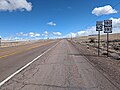
 US 191 near monument valley.jpg 2,272 × 1,712; 492 KB
.jpg)
.jpg)
.jpg)


.jpg)


.jpg)


_map.svg)
.jpg)
.jpg)
.jpg)


.svg)