File:Erdbebenzonen.png
Jump to navigation
Jump to search

Size of this preview: 507 × 599 pixels. Other resolutions: 203 × 240 pixels | 406 × 480 pixels | 650 × 768 pixels | 866 × 1,024 pixels | 1,902 × 2,248 pixels.
Original file (1,902 × 2,248 pixels, file size: 144 KB, MIME type: image/png)
Captions
Captions
Add a one-line explanation of what this file represents

|
This geology image could be re-created using vector graphics as an SVG file. This has several advantages; see Commons:Media for cleanup for more information. If an SVG form of this image is available, please upload it and afterwards replace this template with
{{vector version available|new image name}}.
It is recommended to name the SVG file “Erdbebenzonen.svg”—then the template Vector version available (or Vva) does not need the new image name parameter. |
Summary
[edit]
| Description |
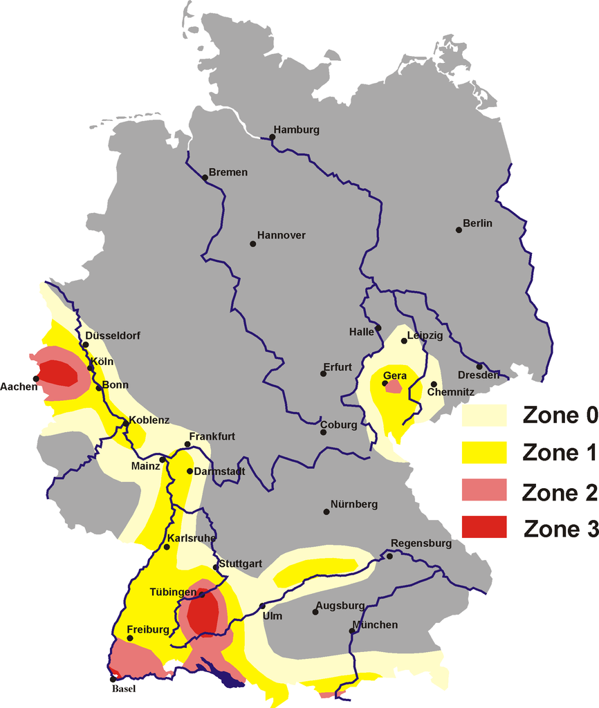
English: Map of German earthquake areas. Showing the areas with following design ground accelerations after DIN EN 1998-1 NA (Germany).
Deutsch: Erdbebenzonenkarte für Deutschland. Dargestellt sind die Zonen mit den folgenden Bemessungswerten der Bodenbeschleunigung nach DIN EN 1998-1 NA.
Zone 3: a = 0,8 m/s² |
| Date | |
| Source |
selbst gezeichnet based on [.. Template/Data-Source? ..] |
| Author | Störfix |
Licensing
[edit]
This file is licensed under the Creative Commons Attribution 2.0 Germany license.
- You are free:
- to share – to copy, distribute and transmit the work
- to remix – to adapt the work
- Under the following conditions:
- attribution – You must give appropriate credit, provide a link to the license, and indicate if changes were made. You may do so in any reasonable manner, but not in any way that suggests the licensor endorses you or your use.

File history
Click on a date/time to view the file as it appeared at that time.
| Date/Time | Thumbnail | Dimensions | User | Comment | |
|---|---|---|---|---|---|
| current | 21:33, 19 December 2005 | | 1,902 × 2,248 (144 KB) | Störfix (talk | contribs) | |
| 10:56, 17 December 2005 |  | 1,902 × 2,248 (141 KB) | Störfix (talk | contribs) | *'''Description:''' earthquake aeras of Germany <br/> *'''Source:''' selbst abgezeichnet von DIN 4149<br/> Erdbebenzonenkarte *'''Date:''' 17. Dec. 2005<br/> *'''Author:''' Störfix<br/> {{Bild-PD}} Category:Germany |
You cannot overwrite this file.
File usage on Commons
The following page uses this file:
File usage on other wikis
The following other wikis use this file:
- Usage on de.wikipedia.org
- Oberrheinische Tiefebene
- Schwäbische Alb
- Landkreis Waldshut
- Waldshut-Tiengen
- Bemessungskriterien (Erdbeben)
- Erdbebengebiet Kölner Bucht
- Großer Heuberg
- Kernkraftwerk Fessenheim
- Erdbebensicheres Bauen
- Liste von Erdbeben in Deutschland
- Benutzer:DF5GO/Spielwiese
- Hochrheingebiet
- Erdbebenzone
- Landeserdbebendienst Baden-Württemberg
- Erdbebenschwärme im Vogtland
- Usage on de.wikibooks.org
- Usage on en.wikipedia.org
- Usage on eo.wikipedia.org
- Usage on fr.wikipedia.org
- Usage on ksh.wikipedia.org
- Usage on www.wikidata.org