File:Etruscan civilization italian map.png
Jump to navigation
Jump to search
Size of this preview: 494 × 600 pixels. Other resolutions: 198 × 240 pixels | 395 × 480 pixels | 633 × 768 pixels | 843 × 1,024 pixels | 1,500 × 1,821 pixels.
Original file (1,500 × 1,821 pixels, file size: 413 KB, MIME type: image/png)
Captions
Captions
Add a one-line explanation of what this file represents
Summary
[edit]| Description |
[]
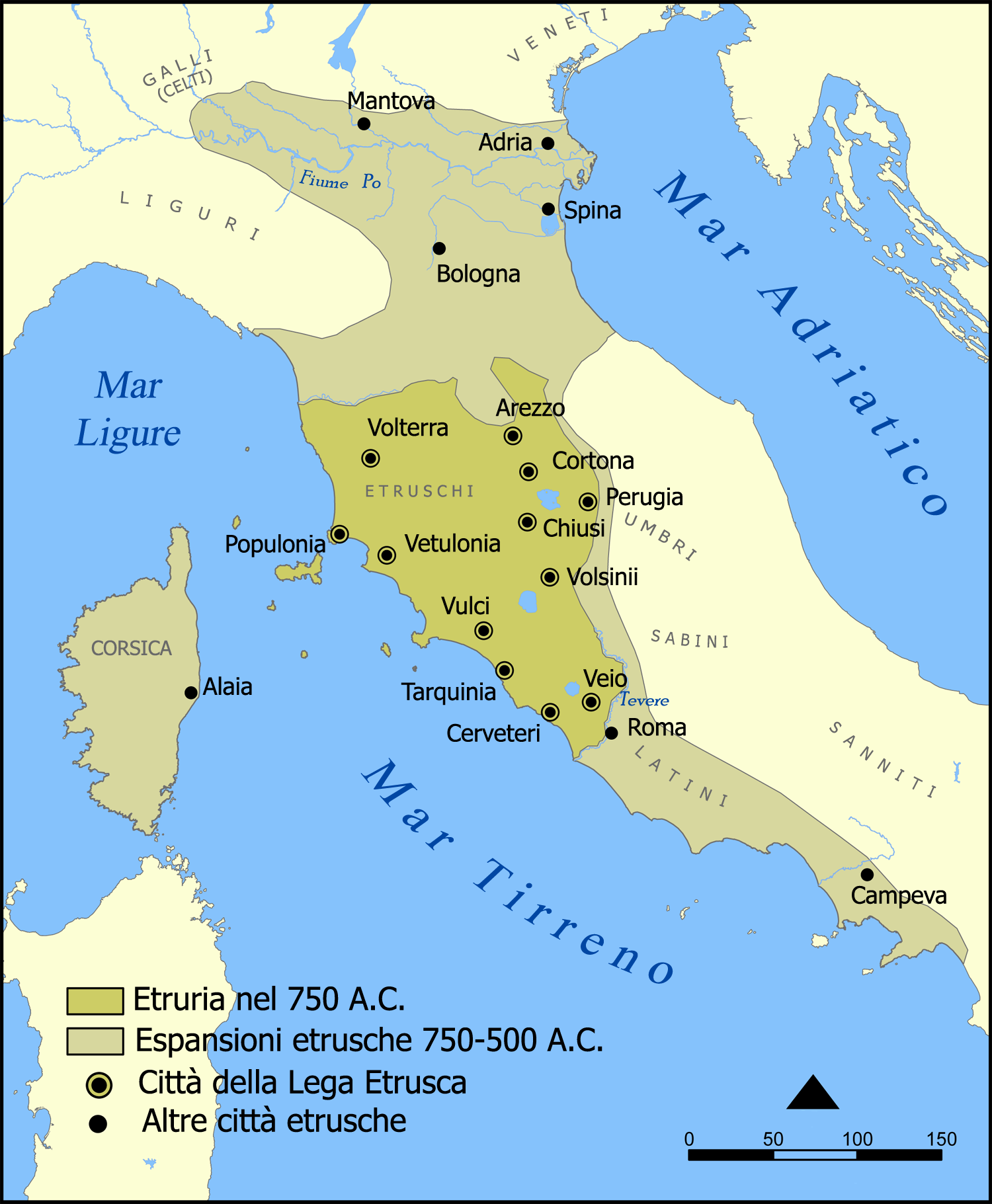
Català: Un mapa que mostra l'extensió d'Etruria i la civilització etrusca. El mapa inclou les 12 ciutats de la Lliga Etrusca i ciutats notables fundades pels etruscs. Les dates del mapa són una aproximació. English: A map showing the extent of Etruria and the Etruscan civilization. The map includes the 12 cities of the Etruscan League and notable cities founded by the Etruscans. The dates on the map are an approximation. Español: Expansión etrusca entre el 750 y el 500 a. de C., las ciudades de la Liga etrusca y otras notables fundadas por los etruscos. Português: Mapa da expansão etrusca entre 750-500 Suomi: Kartta Etruriasta ja etruskien sivilisaatiosta sen ollessa laajimmillaan. Karttaan on merkitty etruskien kaupunkiliiton 12 kaupunkia sekä muita etruskien perustamia merkittäviä kaupunkeja. Ελληνικά: Χάρτης της Ετρουρίας Беларуская: Карта паказвае абрысы Этрурыі і этрускай цывілізацыі. Яна ўключае 12 асноўных гарадоў этрускай лігі і іншыя горады, заснаваныя этрускамі. ქართული: ეტრუსკული ცივილიზაციის რუკა. עברית : מפה המציגה את היקף אטרוריה והציוויליזציה האטרוסקית. המפה כוללת את 12 ערי הליגה האטרוסקית וערים בולטות שנוסדו על ידי האטרוסקים. התאריכים במפה הם בקירוב. العربية : خريطة تُظهر نطاق الحضارتين الإترورياويَّة والإتروسكانيَّة. تتضمَّن هذه الخريطة 12 مدينة انتمت إلى الرابطة الإتروسكانيَّة ومُدن مُهمَّة وبارزة أُخرى كانت قائمة ضمن بلاد الإتروسكان. |
||
| Source | From thumb|left|blank version | ||
| Author | MM | ||
| Permission (Reusing this file) |
GFDL, cc-by-sa-2.5 | ||
| Other versions |
[]
|


Licensing
[edit]
I, the copyright holder of this work, hereby publish it under the following licenses:

|
Permission is granted to copy, distribute and/or modify this document under the terms of the GNU Free Documentation License, Version 1.2 or any later version published by the Free Software Foundation; with no Invariant Sections, no Front-Cover Texts, and no Back-Cover Texts. A copy of the license is included in the section entitled GNU Free Documentation License. |
| This file is licensed under the Creative Commons Attribution-Share Alike 3.0 Unported license. | ||
| ||
| This licensing tag was added to this file as part of the GFDL licensing update. |
You may select the license of your choice.
File history
Click on a date/time to view the file as it appeared at that time.
| Date/Time | Thumbnail | Dimensions | User | Comment | |
|---|---|---|---|---|---|
| current | 22:32, 3 January 2007 | | 1,500 × 1,821 (413 KB) | MM (talk | contribs) | == Description == {{Information| |Description={{en|Italian version of a map showing the extent of Etruria and the Etruscan civilization. The map includes the 12 cities of the Etruscan League and notable cities founded by the Etruscans.}} |Source=From [[:I |
You cannot overwrite this file.
File usage on Commons
The following 18 pages use this file:
- File:Civilizacion etrusca.png
- File:Etruscan civilization HE.png
- File:Etruscan civilization blank map.png
- File:Etruscan civilization georgian map.png
- File:Etruscan civilization italian map.png
- File:Etruscan civilization map-ar.png
- File:Etruscan civilization map-be.png
- File:Etruscan civilization map-de.png
- File:Etruscan civilization map-el.png
- File:Etruscan civilization map-fi.png
- File:Etruscan civilization map.png
- File:Etruscan civilization map ua.PNG
- File:Etruskische beschaving.png
- File:Etruskische beschaving.svg
- File:Expansão etrusca-es.svg
- File:Expansão etrusca-pt.svg
- File:Étrurie.png
- Template:Other versions/Etruscan civilization map
File usage on other wikis
The following other wikis use this file:
- Usage on bg.wikipedia.org
- Usage on br.wikipedia.org
- Usage on ca.wikipedia.org
- Usage on co.wikipedia.org
- Usage on eo.wikipedia.org
- Usage on hu.wikipedia.org
- Usage on io.wikipedia.org
- Usage on it.wikipedia.org
- Latini
- Mar Tirreno
- Perugia
- Corsica
- Regio VII Etruria
- Felsina
- Popoli dell'Italia antica
- Storia della Corsica
- Etruria
- Dodecapoli etrusca
- Guerre tra Roma e Veio
- Storia di Monteleone d'Orvieto
- Storia d'Italia
- Storia delle campagne dell'esercito romano in età repubblicana
- Etruschi
- Discussione:Storia d'Italia/Sandbox
- Etruria campana
- Etruria padana
- Carro etrusco di Monteleone
- Portale:Etruschi
- Portale:Etruschi/Storia
- Storia della Spezia
- Utente:Francesco Ippolito/Libri/Italia
- Utente:Barjimoa/Sandbox
- Usage on it.wikiquote.org
- Usage on la.wikipedia.org
- Usage on roa-tara.wikipedia.org
- Usage on scn.wikipedia.org
- Usage on sl.wikipedia.org
- Usage on sq.wikipedia.org
- Usage on vec.wikipedia.org
- Usage on www.wikidata.org