File:Extent of the Roman Republic and the Roman Empire between 218 BC and 117 AD.png
Jump to navigation
Jump to search
Size of this preview: 800 × 500 pixels. Other resolutions: 320 × 200 pixels | 640 × 400 pixels | 1,024 × 640 pixels | 1,280 × 800 pixels | 2,850 × 1,781 pixels.
Original file (2,850 × 1,781 pixels, file size: 3.9 MB, MIME type: image/png)
Captions
Captions
Add a one-line explanation of what this file represents
Summary
[edit]
| Description |
Asturianu: L'Kinans Empire
nel 133 BC (d'escuru y colloráu).
Català: Expansió de l'Imperi Romà el 218 a.C. (vermell), 133 a.C. (rosa), 44 a.C. (taronja), 14 d.C. (groc), i 117 d.C. (verd).
Cymraeg: Yr Ymerodraeth Rufeinig yn 14 (pob lliw heblaw gwyrdd a llwyd).
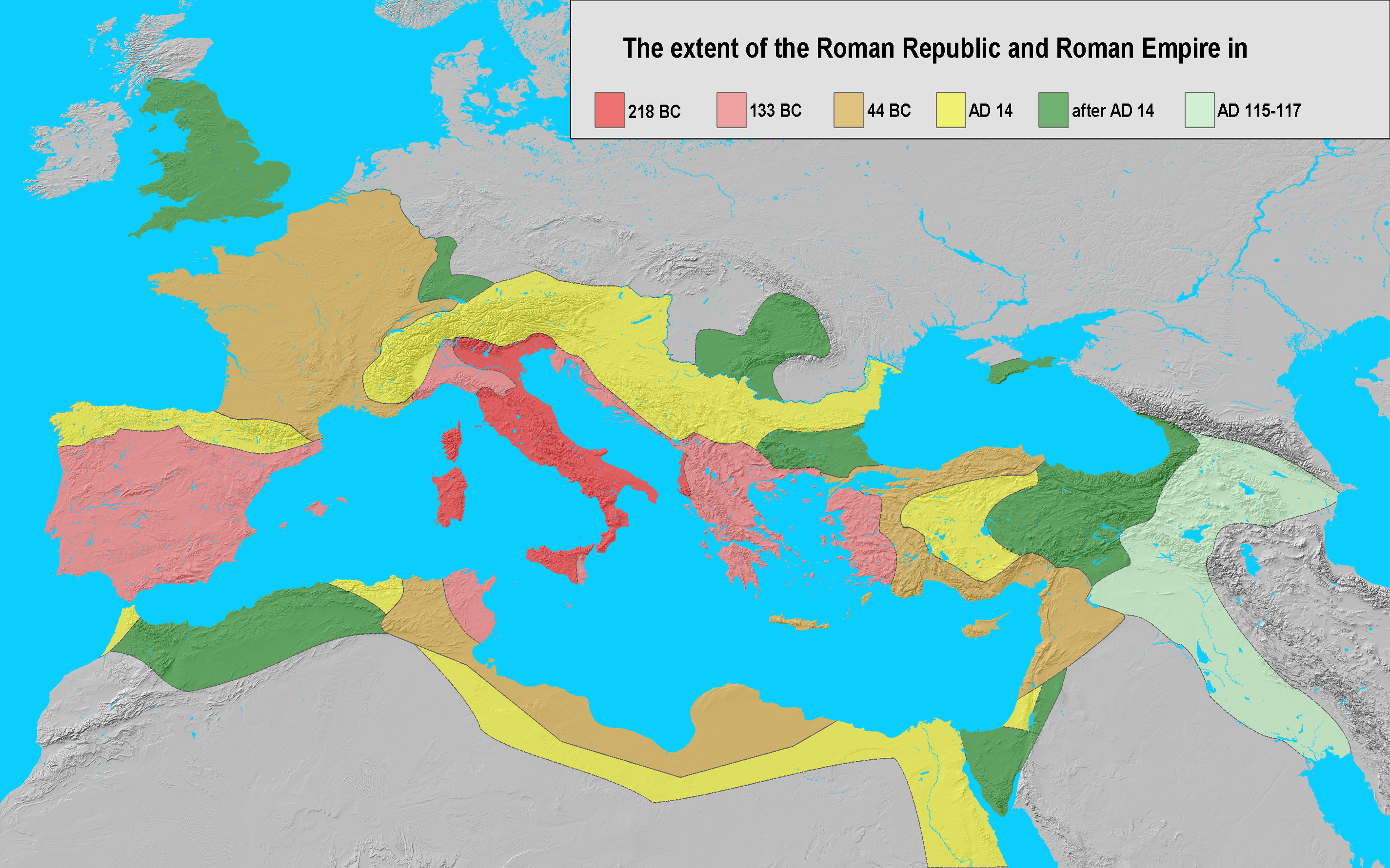
English: Extent of the Roman Republic (509 BC–27 BC) and Roman Empire (27 BC–476/1453 AD) in 218 BC (dark red), 133 BC (light red), 44 BC (orange), 14 AD (yellow), after 14 AD (green) and maximum extension under Trajan 117 (light green).
Español: Expansión del Imperio Romano en 218 (rojo), 133 (rosa), 44 a.C. (naranja), 14 (amarillo), y 117 (verde). Suomi: Rooman valtakunta 44 eaa.
Français : Évolution des territoires contrôlés par l'Empire romain jusqu'à sa chute en 476.
Galego: Expansión do Imperio Romano en 133 a.dC. (vermello), 44 a-dC. (laranxa), 14 (amarelo), e 117 (verde). A extensión da república romana en 218 a. C. (vermello oscuro), 133 a. C. (rosado), 44 a. C. (laranxa), 14 d. C. ( amarelo), despoís 14 d. C. (verde) e unha extensión máxima baixo o gobierno de Trajano, 117 d. C. (verde claro).
客家語 / Hak-kâ-ngî:Lò-mâ Ti-koet.
Italiano: Fasi dell'espansionismo romano dal 218 a.C. al 117 d.C..
日本語: 紀元前44年頃のローマ帝国の範囲.
한국어: 로마제국은 북쪽으로는 브리타니아, 남쪽으로는 팔레스타인 지역까지 영토를 확장하였다.
Nederlands: De groei van het Romeinse Rijk tijdens de late republiek en het vroege principaat; ██ 218 v.Chr. (voor de Tweede Punische Oorlog) ██ 133 v.Chr. (begin van onrust in de republiek) ██ 44 v.Chr. (dood van Julius Caesar) ██ 14 v.Chr. (tijdens het principaat van Augustus) ██ uitbreidingen in de eerste eeuw n.Chr. ██ 114-117 n.Chr. (tijdelijke uitbreiding onder Trajanus).
Piemontèis: Surfasse dla Repùblica e dl'Imperi dël 218 aGC (ross ëscur), 133 aGC (reusa), 44 aGC (groson), 14 dGC (giàun), dapress al 14 dGC (vèrd), e surfassa màssima sot a Trajan, 117 dGC (vërzolin).
Русский: Земли Римской Республики (509–27 до н.э.) и Римской Империи (27 до н.э. –476/1453 н.э.) в 218 г. до н.э. (темно красный), 133 г. до н.э. (светло красный), 44 г. до н.э. (оранжевый), 14 г. н.э. (желтый), после 14 г н.э. (зеленый) и достигшие максимума при Траяне в 117 г. н.э. (светло зеленый).
Srpskohrvatski / српскохрватски: Rimska država godine 44. pne. (označeno svjetlocrvenom, tamnocrvenom i narančastom bojom). Rimske teritorije godine 218. pne. (tamnocrveno). Rimska Republika godine 133. pne. (područja označena crveno i svjetlocrveno). Rimsko Carstvo godine 14. n.e. (sve boje osim zelene i sive).
Simple English: The extent of the Roman Republic and Roman Empire in 218 BC (dark red), 133 BC (light red), 44 BC (orange), AD 14 (yellow), after AD 14 (green), and maximum extension under Trajan 117 (light green).
Српски / srpski: Римска република и Римско царство: 215. п. н. е. (тамно црвено),133. п. н. е. (свијетло црвено), 44. п. н. е. (оранж), 14 н. ере (жуто), даља освајања (зелено) и Трајанова освајања на истоку (свијетло зелено).
Svenska: Romerska riket 14 e.Kr. (alla färger utom mörk- och ljusgrönt samt grått). Romerska riket 44 f.Kr. (i mörk- och ljusrött samt oranget). Romerska republiken 218 f.Kr. (i mörkrött). Romerska riket 133 f.Kr. (i mörk- och ljusrött).
தமிழ்: கிமு 44 இல் ரோமன் பேரரசு (கடும், இளம் சிவப்பு மற்றும் செம்மஞ்சள் நிறத்தில் காட்டப்பட்டுள்ளது.). |
| Date | |
| Source | own work; base map from Natural Earth |
| Author | Varana |
| Permission (Reusing this file) |
GDFL, CC-BY-SA |

|
This historical map image could be re-created using vector graphics as an SVG file. This has several advantages; see Commons:Media for cleanup for more information. If an SVG form of this image is available, please upload it and afterwards replace this template with
{{vector version available|new image name}}.
It is recommended to name the SVG file “Extent of the Roman Republic and the Roman Empire between 218 BC and 117 AD.svg”—then the template Vector version available (or Vva) does not need the new image name parameter. |
Licensing
[edit]
I, the copyright holder of this work, hereby publish it under the following licenses:

|
Permission is granted to copy, distribute and/or modify this document under the terms of the GNU Free Documentation License, Version 1.2 or any later version published by the Free Software Foundation; with no Invariant Sections, no Front-Cover Texts, and no Back-Cover Texts. A copy of the license is included in the section entitled GNU Free Documentation License. |
| This file is licensed under the Creative Commons Attribution-Share Alike 3.0 Unported license. | ||
| ||
| This licensing tag was added to this file as part of the GFDL licensing update. |
This file is licensed under the Creative Commons Attribution-Share Alike 2.5 Generic, 2.0 Generic and 1.0 Generic license.
- You are free:
- to share – to copy, distribute and transmit the work
- to remix – to adapt the work
- Under the following conditions:
- attribution – You must give appropriate credit, provide a link to the license, and indicate if changes were made. You may do so in any reasonable manner, but not in any way that suggests the licensor endorses you or your use.
- share alike – If you remix, transform, or build upon the material, you must distribute your contributions under the same or compatible license as the original.
You may select the license of your choice.
File history
Click on a date/time to view the file as it appeared at that time.
| Date/Time | Thumbnail | Dimensions | User | Comment | |
|---|---|---|---|---|---|
| current | 12:01, 26 October 2011 | | 2,850 × 1,781 (3.9 MB) | Alexander Vigo (talk | contribs) | Correction in the northwestern Iberian peninsula. The Decimus Junius Brutus Callaicus´ expedition (137 B.C) arrived only to river Miño. |
| 18:35, 4 January 2008 |  | 2,850 × 1,781 (3.99 MB) | EliasAlucard~commonswiki (talk | contribs) | corrected aspect ratio | |
| 09:21, 25 November 2006 |  | 2,850 × 1,500 (3.01 MB) | Varana (talk | contribs) | == Beschreibung == {{Information |Description=Extent of the Roman Empire in 218 BC (dark red), 133 BC (light red), 44 BC (orange), AD 14 (yellow), later acquisitions (green) and Trajan's Eastern conquests (light green). |Source=own work; base map from [ht | |
| 19:41, 24 November 2006 |  | 2,850 × 1,500 (3.01 MB) | Varana (talk | contribs) | {{Information |Description=Extent of the Roman Empire in 218 BC (dark red), 133 BC (light red), 44 BC (orange), AD 14 (yellow), later acquisitions (green) and Trajan's Eastern conquests (light green). |Source=own work; base map from [http://www.shadedreli |
You cannot overwrite this file.
File usage on Commons
The following 3 pages use this file:
- Atlas of the Levant
- Atlas of the antiquity
- File:RomanEmpire Phases.png (file redirect)
File usage on other wikis
The following other wikis use this file:
- Usage on ar.wikipedia.org
- Usage on ast.wikipedia.org
- Usage on bn.wikipedia.org
- Usage on ca.wikipedia.org
- Usage on cs.wikipedia.org
- Usage on cy.wikipedia.org
- Usage on de.wikipedia.org
- Usage on en.wikipedia.org
- AD 14
- 44 BC
- 133 BC
- Classical antiquity
- Talk:Roman Empire/Archive 4
- History of Roman-era Tunisia
- Wikipedia:Wikipedia Signpost/2013-05-20/WikiProject report
- Wikipedia:Wikipedia Signpost/Single/2013-05-20
- User:Fuzzycatty/sandbox
- User:Fuzzycatty/HellenizationInFirstCenturyJudea
- User:Falcaorib/Ancient Empires (01 AD-150 AD)
- Usage on es.wikipedia.org
- Usage on et.wikipedia.org
- Usage on eu.wikipedia.org
- Usage on fi.wikipedia.org
- Usage on fr.wikipedia.org
- Usage on gl.wikipedia.org
- Usage on hak.wikipedia.org
- Usage on he.wikipedia.org
- Usage on hy.wikipedia.org
- Usage on id.wikipedia.org
- Usage on it.wikipedia.org
- Usage on ja.wikipedia.org
- Usage on ko.wikipedia.org
- Usage on lv.wikipedia.org
- Usage on ms.wikipedia.org
- Usage on nl.wikipedia.org
- Usage on nl.wikibooks.org
- Usage on no.wikipedia.org
- Usage on pms.wikipedia.org
- Usage on pnb.wikipedia.org
- Usage on ru.wikipedia.org
View more global usage of this file.